Baisha elevation
Baisha (Hunan), China elevation is 107 meters and Baisha elevation in feet is 351 ft above sea level [src 1]. Baisha is a seat of a third-order administrative division (feature code) with elevation that is 451 meters (1480 ft) smaller than average city elevation in China.
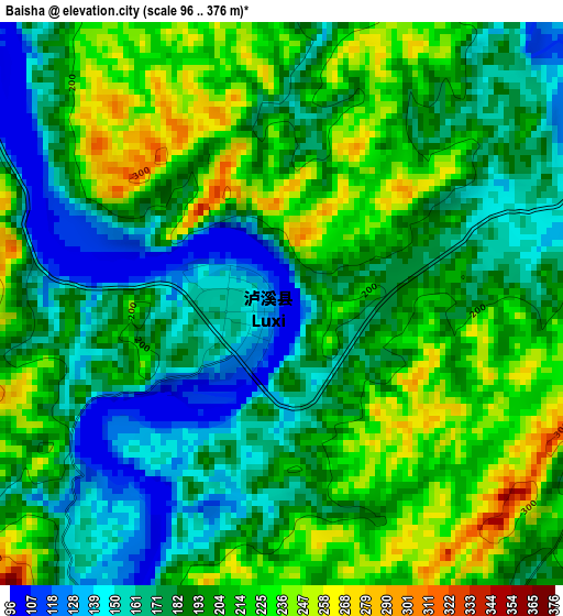
Below is the Elevation map of Baisha, which displays elevation range with different colors. Scale of the first map is from 96 to 376 m (315 to 1234 ft) with average elevation of 194.5 meters (=638 ft) [note 1]
These maps also provides idea of topography and contour of this city, they are displayed at different zoom levels. More info about maps, scale and edge coordinates you can find below images.
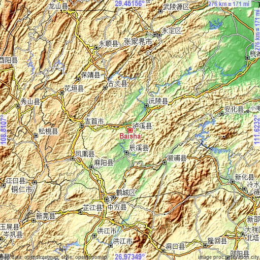
| \ | Map #1 | Topo.Map |
| Scale [m] | 96..376 m | × |
| Scale [ft] | 315..1234 ft | × |
| Average | 194.5 m = 638 ft | × |
| Width | 8.61 km = 5.3 mi | 275.5 km = 171.2 mi |
| Height | 8.61 km = 5.3 mi | 275.5 km = 171.2 mi |
| ↑Max Latitude | 28.258425° | 29.45156° |
| Latitude at center | 28.21971° | 28.21971° |
| ↓Min Latitude | 28.180981° | 26.97349° |
| ← Min Longitude | 110.173005° | 108.8107° |
| Longitude center | 110.21695° | 110.21695° |
| →Max Longitude | 110.260895° | 111.6232° |
Nearby cities:
Cities around Baisha sort by population:
• Qianzhou elevation 201 m
48.6 km,  283°
283°
• Anping 138 m
40.5 km,  194°
194°
• Dehang 245 m
42.3 km, 283°
• Huomachong 178 m
37.4 km,  178°
178°
• Lanli 149 m
47.2 km,  218°
218°
• Tanwan 137 m
28.9 km, 193°
• Xiaolongmen 187 m
46.8 km, 186°
• Xianrenwan 151 m
52.9 km,  167°
167°
• Guyang 364 m
51.9 km,  327°
327°
• Lufeng 162 m
50 km,  133°
133°
• Yuanling 120 m
31.2 km,  35°
35°
• Chenyang 206 m
23.1 km, 190°
Multilingual:
 En español:
Baisha elevación 107 m.
 En France:
Baisha élévation 107 m.


Sources and notes:
- [note 1] Map square and city borders are not equal. Map elevation data is calculated only from area inside that square.
- [src 1] Elevation data from geonames database provided with same terms of usage.
- [src 2] The elevation map of Baisha is generated using elevation data from NASA's 3 arcsec (90m) resolution SRTM data.
- [src 3] Base (background) map © OpenStreetMap contributors tiles are generated by Geofabrik and OpenTopoMap.
Copyright & License:
This Baisha Elevation Map is licensed under CC BY-SA. You may reuse any part from this page, if you give a proper credit by linking to this URL:
 More info on terms of use page.