Dehang elevation
Dehang (Hunan), China elevation is 245 meters and Dehang elevation in feet is 804 ft above sea level [src 1]. Dehang is a populated place (feature code) with elevation that is 313 meters (1027 ft) smaller than average city elevation in China.
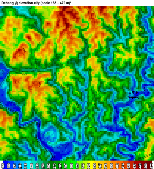
Below is the Elevation map of Dehang, which displays elevation range with different colors. Scale of the first map is from 168 to 472 m (551 to 1549 ft) with average elevation of 287.8 meters (=944 ft) [note 1]
These maps also provides idea of topography and contour of this city, they are displayed at different zoom levels. More info about maps, scale and edge coordinates you can find below images.
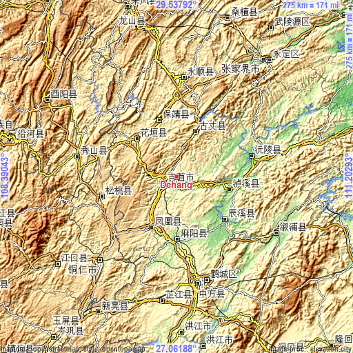
| \ | Map #1 | Topo.Map |
| Scale [m] | 168..472 m | × |
| Scale [ft] | 551..1549 ft | × |
| Average | 287.8 m = 944 ft | × |
| Width | 8.6 km = 5.3 mi | 275.3 km = 171.1 mi |
| Height | 8.6 km = 5.3 mi | 275.3 km = 171.1 mi |
| ↑Max Latitude | 28.345783° | 29.53792° |
| Latitude at center | 28.3071° | 28.3071° |
| ↓Min Latitude | 28.268403° | 27.06188° |
| ← Min Longitude | 109.752735° | 108.39043° |
| Longitude center | 109.79668° | 109.79668° |
| →Max Longitude | 109.840625° | 111.20293° |
Nearby cities:
Cities around Dehang sort by population:
• Fenghuang elevation 449 m
45.6 km,  205°
205°
• Qianzhou 201 m
6.3 km,  282°
282°
• Lanli 149 m
48.2 km,  165°
165°
• Tanwan 137 m
51.4 km,  137°
137°
• Yanmen 161 m
50.6 km,  186°
186°
• Chenyang 206 m
49.1 km,  131°
131°
• Gaocun 177 m
47.8 km,  181°
181°
• Qianling 236 m
47.4 km,  341°
341°
• Tuojiang 378 m
45.1 km, 209°
• Huayuan 302 m
44.3 km,  314°
314°
• Baisha 107 m
42.3 km,  103°
103°
• Guyang 364 m
36.6 km,  21°
21°
Multilingual:
 En español:
Dehang elevación 245 m.
 En France:
Dehang élévation 245 m.


Sources and notes:
- [note 1] Map square and city borders are not equal. Map elevation data is calculated only from area inside that square.
- [src 1] Elevation data from geonames database provided with same terms of usage.
- [src 2] The elevation map of Dehang is generated using elevation data from NASA's 3 arcsec (90m) resolution SRTM data.
- [src 3] Base (background) map © OpenStreetMap contributors tiles are generated by Geofabrik and OpenTopoMap.
Copyright & License:
This Dehang Elevation Map is licensed under CC BY-SA. You may reuse any part from this page, if you give a proper credit by linking to this URL:
 More info on terms of use page.