Fenghuang elevation
Fenghuang (Hunan), China elevation is 449 meters and Fenghuang elevation in feet is 1473 ft above sea level [src 1]. Fenghuang is a populated place (feature code) with elevation that is 109 meters (358 ft) smaller than average city elevation in China.
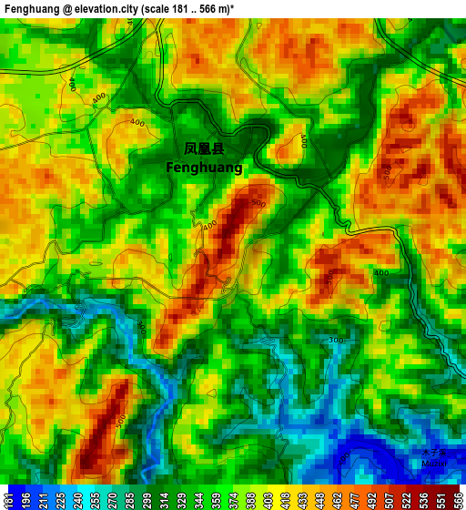
Below is the Elevation map of Fenghuang, which displays elevation range with different colors. Scale of the first map is from 181 to 566 m (594 to 1857 ft) with average elevation of 371.8 meters (=1220 ft) [note 1]
These maps also provides idea of topography and contour of this city, they are displayed at different zoom levels. More info about maps, scale and edge coordinates you can find below images.
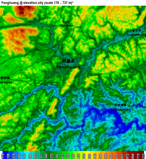
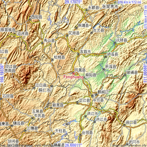
| \ | Map #1 | Map #2 | Topo.Map |
| Scale [m] | 181..566 m | 176..737 m | × |
| Scale [ft] | 594..1857 ft | 577..2418 ft | × |
| Average | 371.8 m = 1220 ft | 389.3 m = 1277 ft | × |
| Width | 8.63 km = 5.4 mi | 17.27 km = 10.7 mi | 276.3 km = 171.7 mi |
| Height | 8.63 km = 5.4 mi | 17.27 km = 10.7 mi | 276.3 km = 171.7 mi |
| ↑Max Latitude | 27.974388° | 28.013191° | 29.17075° |
| Latitude at center | 27.93557° | 27.93557° | 27.93557° |
| ↓Min Latitude | 27.896738° | 27.857893° | 26.68611° |
| ← Min Longitude | 109.555665° | 109.511719° | 108.19336° |
| Longitude center | 109.59961° | 109.59961° | 109.59961° |
| →Max Longitude | 109.643555° | 109.687501° | 111.00586° |
Nearby cities:
Cities around Fenghuang sort by population:
• Qianzhou elevation 201 m
44.6 km,  17°
17°
• Jinhe 202 m
24.3 km,  178°
178°
• Dehang 245 m
45.6 km,  25°
25°
• Lanli 149 m
31.8 km,  99°
99°
• Yanmen 161 m
16.5 km,  122°
122°
• Jiangkouxu 174 m
30 km,  153°
153°
• Yaoshi 256 m
33.6 km,  191°
191°
• Yangtou 302 m
32.9 km,  213°
213°
• Chatian 549 m
26.7 km,  236°
236°
• Shuidatian 256 m
9.3 km, 176°
• Gaocun 177 m
19.3 km,  109°
109°
• Tuojiang 378 m
3.8 km,  304°
304°
Multilingual:
 En español:
Fenghuang elevación 449 m.
 En France:
Fenghuang élévation 449 m.
 Auf Deutsch:
Fenghuang höhe über dem Meeresspiegel ist 449 m.

Sources and notes:
- [note 1] Map square and city borders are not equal. Map elevation data is calculated only from area inside that square.
- [src 1] Elevation data from geonames database provided with same terms of usage.
- [src 2] The elevation map of Fenghuang is generated using elevation data from NASA's 3 arcsec (90m) resolution SRTM data.
- [src 3] Base (background) map © OpenStreetMap contributors tiles are generated by Geofabrik and OpenTopoMap.
Copyright & License:
This Fenghuang Elevation Map is licensed under CC BY-SA. You may reuse any part from this page, if you give a proper credit by linking to this URL:
 More info on terms of use page.