Jinhe elevation
Jinhe (Hunan), China elevation is 202 meters and Jinhe elevation in feet is 663 ft above sea level [src 1]. Jinhe is a populated place (feature code) with elevation that is 356 meters (1168 ft) smaller than average city elevation in China.
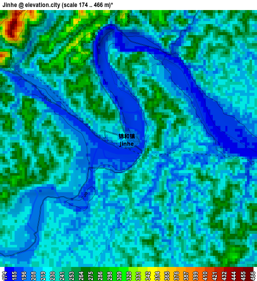
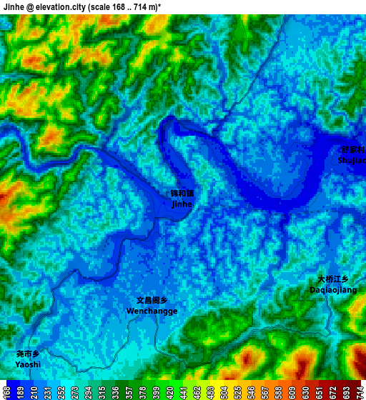
Below is the Elevation map of Jinhe, which displays elevation range with different colors. Scale of the first map is from 174 to 466 m (571 to 1529 ft) with average elevation of 231.4 meters (=759 ft) [note 1]
These maps also provides idea of topography and contour of this city, they are displayed at different zoom levels. More info about maps, scale and edge coordinates you can find below images.
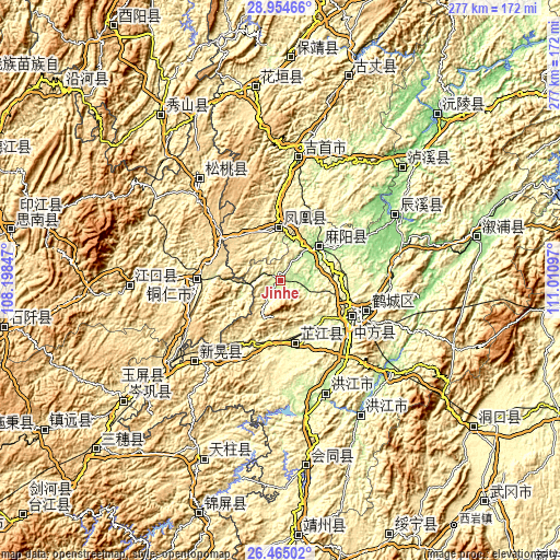
| \ | Map #1 | Map #2 | Topo.Map |
| Scale [m] | 174..466 m | 168..714 m | × |
| Scale [ft] | 571..1529 ft | 551..2343 ft | × |
| Average | 231.4 m = 759 ft | 293.4 m = 963 ft | × |
| Width | 8.65 km = 5.4 mi | 17.3 km = 10.7 mi | 276.8 km = 172 mi |
| Height | 8.65 km = 5.4 mi | 17.3 km = 10.7 mi | 276.8 km = 172 mi |
| ↑Max Latitude | 27.755836° | 27.794718° | 28.95466° |
| Latitude at center | 27.71694° | 27.71694° | 27.71694° |
| ↓Min Latitude | 27.67803° | 27.639107° | 26.46502° |
| ← Min Longitude | 109.560775° | 109.516829° | 108.19847° |
| Longitude center | 109.60472° | 109.60472° | 109.60472° |
| →Max Longitude | 109.648665° | 109.692611° | 111.01097° |
Nearby cities:
Cities around Jinhe sort by population:
• Fenghuang elevation 449 m
24.3 km,  358°
358°
• Luojiu 259 m
30.1 km,  138°
138°
• Lanli 149 m
36.2 km,  58°
58°
• Yanmen 161 m
20.3 km,  40°
40°
• Jiangkouxu 174 m
13.2 km,  101°
101°
• Yaoshi 256 m
11.3 km,  220°
220°
• Yangtou 302 m
19 km,  260°
260°
• Chatian 549 m
24.6 km,  292°
292°
• Shuidatian 256 m
15 km,  0°
0°
• Zhijiang 267 m
29.3 km,  169°
169°
• Tuojiang 378 m
26.7 km,  352°
352°
• Gaocun 177 m
25.1 km, 44°
Multilingual:
 En español:
Jinhe elevación 202 m.
 En France:
Jinhe élévation 202 m.


Sources and notes:
- [note 1] Map square and city borders are not equal. Map elevation data is calculated only from area inside that square.
- [src 1] Elevation data from geonames database provided with same terms of usage.
- [src 2] The elevation map of Jinhe is generated using elevation data from NASA's 3 arcsec (90m) resolution SRTM data.
- [src 3] Base (background) map © OpenStreetMap contributors tiles are generated by Geofabrik and OpenTopoMap.
Copyright & License:
This Jinhe Elevation Map is licensed under CC BY-SA. You may reuse any part from this page, if you give a proper credit by linking to this URL:
 More info on terms of use page.