Wanxian elevation
Wanxian (Chongqing), China elevation is 257 meters and Wanxian elevation in feet is 843 ft above sea level [src 1]. Wanxian is a populated place (feature code) with elevation that is 301 meters (988 ft) smaller than average city elevation in China.
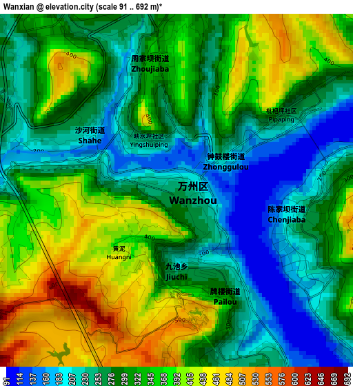
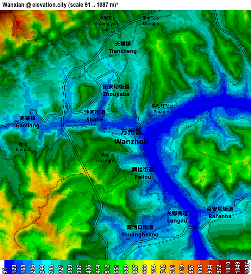
Below is the Elevation map of Wanxian, which displays elevation range with different colors. Scale of the first map is from 91 to 692 m (299 to 2270 ft) with average elevation of 312.3 meters (=1025 ft) [note 1]
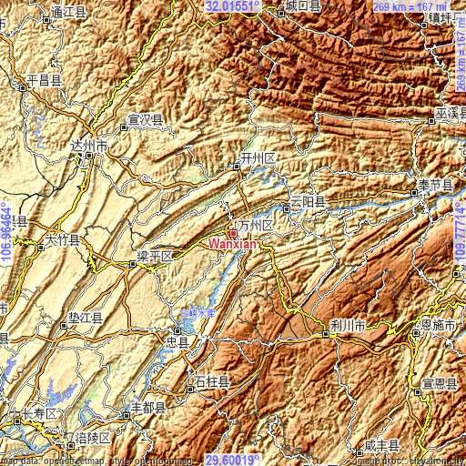
These maps also provides idea of topography and contour of this city, they are displayed at different zoom levels. More info about maps, scale and edge coordinates you can find below images.
| \ | Map #1 | Map #2 | Topo.Map |
| Scale [m] | 91..692 m | 91..1087 m | × |
| Scale [ft] | 299..2270 ft | 299..3566 ft | × |
| Average | 312.3 m = 1025 ft | 378.9 m = 1243 ft | × |
| Width | 8.39 km = 5.2 mi | 16.79 km = 10.4 mi | 268.6 km = 166.9 mi |
| Height | 8.39 km = 5.2 mi | 16.79 km = 10.4 mi | 268.6 km = 166.9 mi |
| ↑Max Latitude | 30.853174° | 30.890893° | 32.01551° |
| Latitude at center | 30.81544° | 30.81544° | 30.81544° |
| ↓Min Latitude | 30.777691° | 30.739928° | 29.60019° |
| ← Min Longitude | 108.326945° | 108.282999° | 106.96464° |
| Longitude center | 108.37089° | 108.37089° | 108.37089° |
| →Max Longitude | 108.414835° | 108.458781° | 109.77714° |
Nearby cities:
Cities around Wanxian sort by population:
• Dazhou elevation 309 m
94.1 km,  298°
298°
• Lichuan 1255 m
73.4 km,  141°
141°
• Guixi 412 m
111.8 km,  241°
241°
• Yong’an 345 m
106.2 km,  77°
77°
• Xiwai 314 m
96.3 km, 297°
• Nanbin 549 m
94.1 km,  195°
195°
• Nanwai 313 m
93.3 km, 297°
• Zhongzhou 230 m
66.4 km,  209°
209°
• Xinning 462 m
56.8 km, 301°
• Hanfeng 182 m
39.5 km,  4°
4°
• Shuangjiang 224 m
32.8 km,  64°
64°
• Chenjiaba 252 m
0.3 km,  127°
127°
Multilingual:
 En español:
Wanxian elevación 257 m.
 En France:
Wanxian élévation 257 m.


Sources and notes:
- [note 1] Map square and city borders are not equal. Map elevation data is calculated only from area inside that square.
- [src 1] Elevation data from geonames database provided with same terms of usage.
- [src 2] The elevation map of Wanxian is generated using elevation data from NASA's 3 arcsec (90m) resolution SRTM data.
- [src 3] Base (background) map © OpenStreetMap contributors tiles are generated by Geofabrik and OpenTopoMap.
Copyright & License:
This Wanxian Elevation Map is licensed under CC BY-SA. You may reuse any part from this page, if you give a proper credit by linking to this URL:
 More info on terms of use page.