Birigui elevation
Birigui (São Paulo), Brazil elevation is 409 meters and Birigui elevation in feet is 1342 ft above sea level [src 1]. Birigui is a populated place (feature code) with elevation that is 27 meters (89 ft) bigger than average city elevation in Brazil.
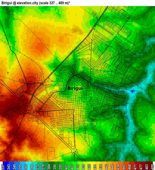
Below is the Elevation map of Birigui, which displays elevation range with different colors. Scale of the first map is from 337 to 489 m (1106 to 1604 ft) with average elevation of 418.9 meters (=1374 ft) [note 1]
These maps also provides idea of topography and contour of this city, they are displayed at different zoom levels. More info about maps, scale and edge coordinates you can find below images.

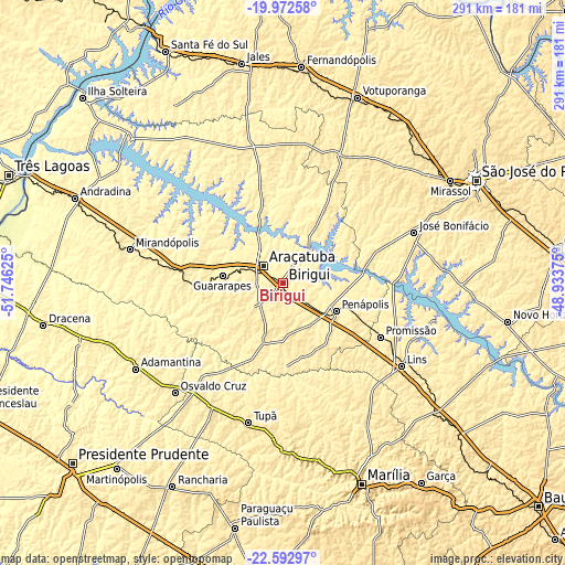
| \ | Map #1 | Map #2 | Topo.Map |
| Scale [m] | 337..489 m | 337..495 m | × |
| Scale [ft] | 1106..1604 ft | 1106..1624 ft | × |
| Average | 418.9 m = 1374 ft | 411.5 m = 1350 ft | × |
| Width | 9.11 km = 5.7 mi | 18.21 km = 11.3 mi | 291.4 km = 181.1 mi |
| Height | 9.11 km = 5.7 mi | 18.21 km = 11.3 mi | 291.4 km = 181.1 mi |
| ↑Max Latitude | -21.247658° | -21.206694° | -19.97258° |
| Latitude at center | -21.28861° | -21.28861° | -21.28861° |
| ↓Min Latitude | -21.329551° | -21.37048° | -22.59297° |
| ← Min Longitude | -50.383945° | -50.427891° | -51.74625° |
| Longitude center | -50.34° | -50.34° | -50.34° |
| →Max Longitude | -50.296055° | -50.252109° | -48.93375° |
Nearby cities:
Cities around Birigui sort by population:
• Araçatuba elevation 392 m
13.1 km,  312°
312°
• Lins 411 m
75.5 km,  125°
125°
• Tupã 528 m
74 km,  194°
194°
• Penápolis 414 m
30.8 km,  118°
118°
• José Bonifácio 437 m
72.5 km,  68°
68°
• Guararapes 413 m
31.5 km,  275°
275°
• Promissão 428 m
57 km, 118°
• Valparaíso 443 m
55.2 km, 277°
• Buritama 400 m
31.8 km,  38°
38°
• Auriflama 473 m
70.7 km,  341°
341°
• Nhandeara 514 m
73.5 km,  25°
25°
• General Salgado 512 m
71.2 km,  358°
358°
Multilingual:
 En español:
Birigui elevación 409 m.
 En France:
Birigüi élévation 409 m.


Sources and notes:
- [note 1] Map square and city borders are not equal. Map elevation data is calculated only from area inside that square.
- [src 1] Elevation data from geonames database provided with same terms of usage.
- [src 2] The elevation map of Birigui is generated using elevation data from NASA's 3 arcsec (90m) resolution SRTM data.
- [src 3] Base (background) map © OpenStreetMap contributors tiles are generated by Geofabrik and OpenTopoMap.
Copyright & License:
This Birigui Elevation Map is licensed under CC BY-SA. You may reuse any part from this page, if you give a proper credit by linking to this URL:
 More info on terms of use page.