Nhandeara elevation
Nhandeara (São Paulo), Brazil elevation is 514 meters and Nhandeara elevation in feet is 1686 ft above sea level [src 1]. Nhandeara is a populated place (feature code) with elevation that is 132 meters (433 ft) bigger than average city elevation in Brazil.
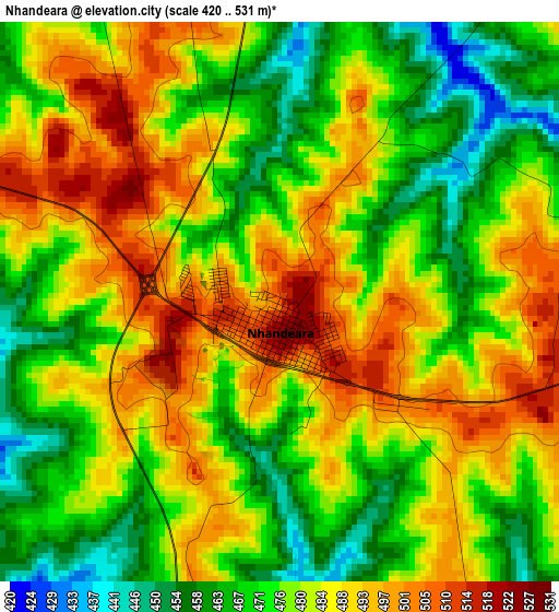
Below is the Elevation map of Nhandeara, which displays elevation range with different colors. Scale of the first map is from 420 to 531 m (1378 to 1742 ft) with average elevation of 480.3 meters (=1576 ft) [note 1]
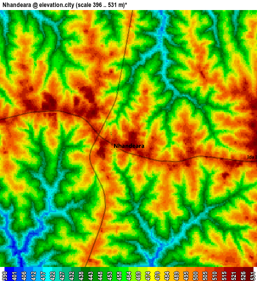
These maps also provides idea of topography and contour of this city, they are displayed at different zoom levels. More info about maps, scale and edge coordinates you can find below images.
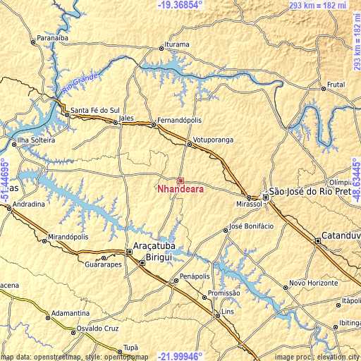
| \ | Map #1 | Map #2 | Topo.Map |
| Scale [m] | 420..531 m | 396..531 m | × |
| Scale [ft] | 1378..1742 ft | 1299..1742 ft | × |
| Average | 480.3 m = 1576 ft | 469.4 m = 1540 ft | × |
| Width | 9.14 km = 5.7 mi | 18.28 km = 11.4 mi | 292.5 km = 181.8 mi |
| Height | 9.14 km = 5.7 mi | 18.28 km = 11.4 mi | 292.5 km = 181.8 mi |
| ↑Max Latitude | -20.648583° | -20.607455° | -19.36854° |
| Latitude at center | -20.6897° | -20.6897° | -20.6897° |
| ↓Min Latitude | -20.730806° | -20.7719° | -21.99946° |
| ← Min Longitude | -50.084645° | -50.128591° | -51.44695° |
| Longitude center | -50.0407° | -50.0407° | -50.0407° |
| →Max Longitude | -49.996755° | -49.952809° | -48.63445° |
Nearby cities:
Cities around Nhandeara sort by population:
• São José do Rio Preto elevation 505 m
70.3 km,  101°
101°
• Votuporanga 528 m
30.5 km,  13°
13°
• Fernandópolis 533 m
49.9 km,  334°
334°
• Jales 507 m
70.4 km,  311°
311°
• José Bonifácio 437 m
54.5 km,  137°
137°
• Tanabi 519 m
41.3 km,  80°
80°
• Monte Aprazível 480 m
35.2 km,  105°
105°
• Bady Bassitt 511 m
66.9 km, 112°
• Buritama 400 m
43.3 km,  194°
194°
• Auriflama 473 m
53.5 km,  270°
270°
• Cardoso 429 m
68.9 km, 11°
• General Salgado 512 m
33.6 km,  277°
277°
Multilingual:
 En español:
Nhandeara elevación 514 m.
 En France:
Nhandeara élévation 514 m.
 Auf Deutsch:
Nhandeara höhe über dem Meeresspiegel ist 514 m.

Sources and notes:
- [note 1] Map square and city borders are not equal. Map elevation data is calculated only from area inside that square.
- [src 1] Elevation data from geonames database provided with same terms of usage.
- [src 2] The elevation map of Nhandeara is generated using elevation data from NASA's 3 arcsec (90m) resolution SRTM data.
- [src 3] Base (background) map © OpenStreetMap contributors tiles are generated by Geofabrik and OpenTopoMap.
Copyright & License:
This Nhandeara Elevation Map is licensed under CC BY-SA. You may reuse any part from this page, if you give a proper credit by linking to this URL:
 More info on terms of use page.