Auriflama elevation
Auriflama (São Paulo), Brazil elevation is 473 meters and Auriflama elevation in feet is 1552 ft above sea level [src 1]. Auriflama is a populated place (feature code) with elevation that is 91 meters (299 ft) bigger than average city elevation in Brazil.
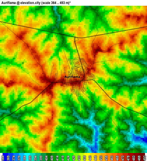
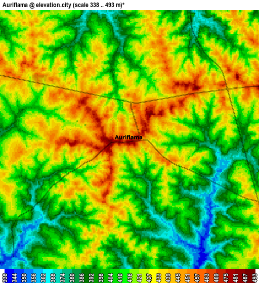
Below is the Elevation map of Auriflama, which displays elevation range with different colors. Scale of the first map is from 364 to 493 m (1194 to 1617 ft) with average elevation of 434 meters (=1424 ft) [note 1]
These maps also provides idea of topography and contour of this city, they are displayed at different zoom levels. More info about maps, scale and edge coordinates you can find below images.
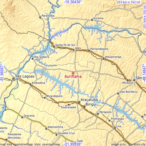
| \ | Map #1 | Map #2 | Topo.Map |
| Scale [m] | 364..493 m | 338..493 m | × |
| Scale [ft] | 1194..1617 ft | 1109..1617 ft | × |
| Average | 434 m = 1424 ft | 415.9 m = 1365 ft | × |
| Width | 9.14 km = 5.7 mi | 18.29 km = 11.4 mi | 292.5 km = 181.8 mi |
| Height | 9.14 km = 5.7 mi | 18.29 km = 11.4 mi | 292.6 km = 181.8 mi |
| ↑Max Latitude | -20.644442° | -20.603313° | -19.36436° |
| Latitude at center | -20.68556° | -20.68556° | -20.68556° |
| ↓Min Latitude | -20.726667° | -20.767762° | -21.99535° |
| ← Min Longitude | -50.598665° | -50.642611° | -51.96097° |
| Longitude center | -50.55472° | -50.55472° | -50.55472° |
| →Max Longitude | -50.510775° | -50.466829° | -49.14847° |
Nearby cities:
Cities around Auriflama sort by population:
• Araçatuba elevation 392 m
59.6 km,  167°
167°
• Birigui 409 m
70.7 km,  161°
161°
• Votuporanga 528 m
67.3 km,  64°
64°
• Fernandópolis 533 m
55 km,  35°
35°
• Jales 507 m
46.3 km,  1°
1°
• Guararapes 413 m
64.6 km,  188°
188°
• Santa Fé do Sul 402 m
65.4 km,  323°
323°
• Pereira Barreto 361 m
57.9 km,  275°
275°
• Valparaíso 443 m
68.5 km,  208°
208°
• Buritama 400 m
59.9 km,  134°
134°
• Nhandeara 514 m
53.5 km,  90°
90°
• General Salgado 512 m
20.6 km,  78°
78°
Multilingual:
 En español:
Auriflama elevación 473 m.
 En France:
Auriflama élévation 473 m.
 Auf Deutsch:
Auriflama höhe über dem Meeresspiegel ist 473 m.

Sources and notes:
- [note 1] Map square and city borders are not equal. Map elevation data is calculated only from area inside that square.
- [src 1] Elevation data from geonames database provided with same terms of usage.
- [src 2] The elevation map of Auriflama is generated using elevation data from NASA's 3 arcsec (90m) resolution SRTM data.
- [src 3] Base (background) map © OpenStreetMap contributors tiles are generated by Geofabrik and OpenTopoMap.
Copyright & License:
This Auriflama Elevation Map is licensed under CC BY-SA. You may reuse any part from this page, if you give a proper credit by linking to this URL:
 More info on terms of use page.