Santa Fé do Sul elevation
Santa Fé do Sul (São Paulo), Brazil elevation is 402 meters and Santa Fé do Sul elevation in feet is 1319 ft above sea level [src 1]. Santa Fé do Sul is a populated place (feature code) with elevation that is 20 meters (66 ft) bigger than average city elevation in Brazil.
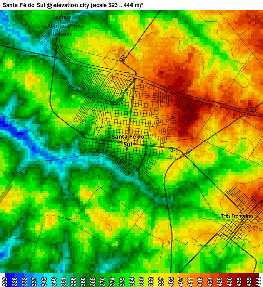
Below is the Elevation map of Santa Fé do Sul, which displays elevation range with different colors. Scale of the first map is from 323 to 444 m (1060 to 1457 ft) with average elevation of 385.3 meters (=1264 ft) [note 1]
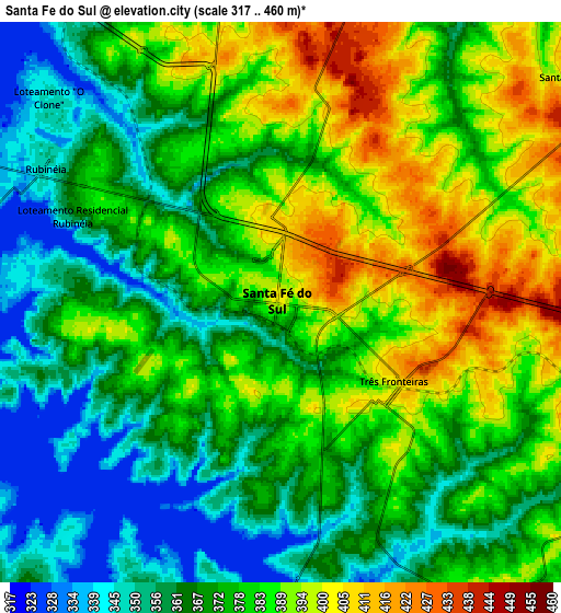
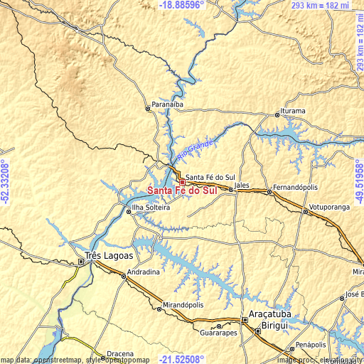
These maps also provides idea of topography and contour of this city, they are displayed at different zoom levels. More info about maps, scale and edge coordinates you can find below images.
| \ | Map #1 | Map #2 | Topo.Map |
| Scale [m] | 323..444 m | 317..460 m | × |
| Scale [ft] | 1060..1457 ft | 1040..1509 ft | × |
| Average | 385.3 m = 1264 ft | 375.3 m = 1231 ft | × |
| Width | 9.17 km = 5.7 mi | 18.34 km = 11.4 mi | 293.4 km = 182.3 mi |
| Height | 9.17 km = 5.7 mi | 18.34 km = 11.4 mi | 293.5 km = 182.4 mi |
| ↑Max Latitude | -20.169865° | -20.128609° | -18.88596° |
| Latitude at center | -20.21111° | -20.21111° | -20.21111° |
| ↓Min Latitude | -20.252344° | -20.293567° | -21.52508° |
| ← Min Longitude | -50.969775° | -51.013721° | -52.33208° |
| Longitude center | -50.92583° | -50.92583° | -50.92583° |
| →Max Longitude | -50.881885° | -50.837939° | -49.51958° |
Nearby cities:
Cities around Santa Fé do Sul sort by population:
• Votuporanga elevation 528 m
102.1 km,  103°
103°
• Fernandópolis 533 m
71.3 km, 96°
• Andradina 417 m
89.6 km,  211°
211°
• Jales 507 m
40.2 km, 99°
• Paranaíba 383 m
65.5 km,  334°
334°
• Iturama 469 m
93.3 km,  54°
54°
• Ilha Solteira 372 m
50 km,  240°
240°
• Pereira Barreto 361 m
51.2 km,  201°
201°
• Aparecida do Taboado 379 m
22.3 km,  308°
308°
• Auriflama 473 m
65.4 km,  143°
143°
• Castilho 382 m
93.9 km,  218°
218°
• General Salgado 512 m
76.4 km,  129°
129°
Multilingual:
 En español:
Santa Fé do Sul elevación 402 m.
 En France:
Santa Fé do Sul élévation 402 m.
 Auf Deutsch:
Santa Fé do Sul höhe über dem Meeresspiegel ist 402 m.

Sources and notes:
- [note 1] Map square and city borders are not equal. Map elevation data is calculated only from area inside that square.
- [src 1] Elevation data from geonames database provided with same terms of usage.
- [src 2] The elevation map of Santa Fé do Sul is generated using elevation data from NASA's 3 arcsec (90m) resolution SRTM data.
- [src 3] Base (background) map © OpenStreetMap contributors tiles are generated by Geofabrik and OpenTopoMap.
Copyright & License:
This Santa Fé do Sul Elevation Map is licensed under CC BY-SA. You may reuse any part from this page, if you give a proper credit by linking to this URL:
 More info on terms of use page.