Iturama elevation
Iturama (Minas Gerais), Brazil elevation is 469 meters and Iturama elevation in feet is 1539 ft above sea level [src 1]. Iturama is a populated place (feature code) with elevation that is 87 meters (285 ft) bigger than average city elevation in Brazil.
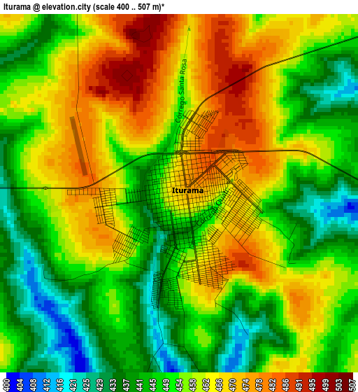
Below is the Elevation map of Iturama, which displays elevation range with different colors. Scale of the first map is from 400 to 507 m (1312 to 1663 ft) with average elevation of 455.4 meters (=1494 ft) [note 1]
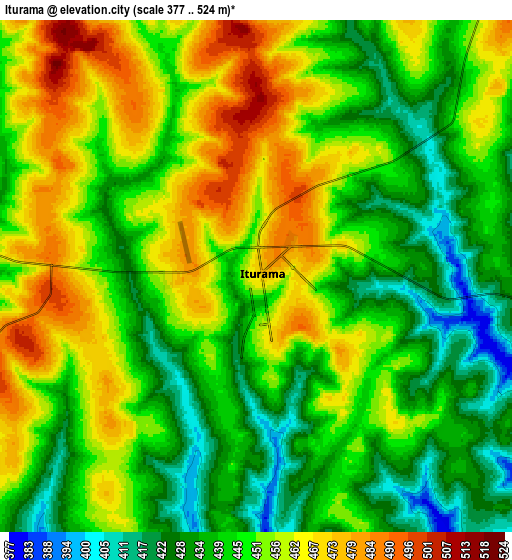
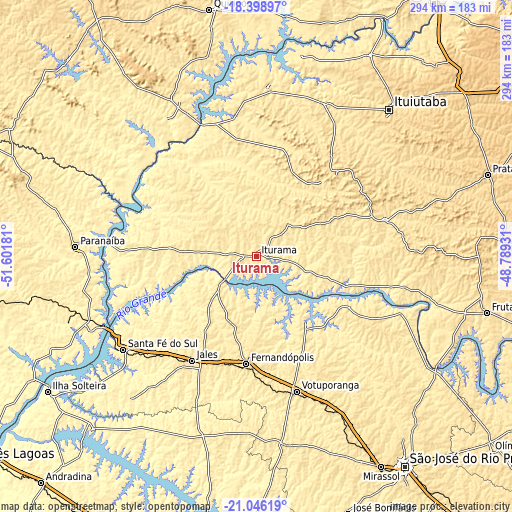
These maps also provides idea of topography and contour of this city, they are displayed at different zoom levels. More info about maps, scale and edge coordinates you can find below images.
| \ | Map #1 | Map #2 | Topo.Map |
| Scale [m] | 400..507 m | 377..524 m | × |
| Scale [ft] | 1312..1663 ft | 1237..1719 ft | × |
| Average | 455.4 m = 1494 ft | 448.2 m = 1470 ft | × |
| Width | 9.2 km = 5.7 mi | 18.4 km = 11.4 mi | 294.3 km = 182.9 mi |
| Height | 9.2 km = 5.7 mi | 18.4 km = 11.4 mi | 294.4 km = 182.9 mi |
| ↑Max Latitude | -19.686689° | -19.645307° | -18.39897° |
| Latitude at center | -19.72806° | -19.72806° | -19.72806° |
| ↓Min Latitude | -19.769421° | -19.81077° | -21.04619° |
| ← Min Longitude | -50.239505° | -50.283451° | -51.60181° |
| Longitude center | -50.19556° | -50.19556° | -50.19556° |
| →Max Longitude | -50.151615° | -50.107669° | -48.78931° |
Nearby cities:
Cities around Iturama sort by population:
• Votuporanga elevation 528 m
80.7 km,  163°
163°
• Fernandópolis 533 m
62 km,  184°
184°
• Jales 507 m
70.4 km,  211°
211°
• Paranaíba 383 m
104.3 km,  273°
273°
• Santa Fé do Sul 402 m
93.3 km,  234°
234°
• Aparecida do Taboado 379 m
102 km,  246°
246°
• Campina Verde 549 m
77 km,  74°
74°
• Santa Vitória 474 m
99.2 km,  4°
4°
• Riolândia 443 m
60.6 km,  117°
117°
• Cardoso 429 m
49.1 km,  143°
143°
• Nhandeara 514 m
108.1 km,  171°
171°
• General Salgado 512 m
103.8 km,  189°
189°
Multilingual:
 En español:
Iturama elevación 469 m.
 En France:
Iturama élévation 469 m.


Sources and notes:
- [note 1] Map square and city borders are not equal. Map elevation data is calculated only from area inside that square.
- [src 1] Elevation data from geonames database provided with same terms of usage.
- [src 2] The elevation map of Iturama is generated using elevation data from NASA's 3 arcsec (90m) resolution SRTM data.
- [src 3] Base (background) map © OpenStreetMap contributors tiles are generated by Geofabrik and OpenTopoMap.
Copyright & License:
This Iturama Elevation Map is licensed under CC BY-SA. You may reuse any part from this page, if you give a proper credit by linking to this URL:
 More info on terms of use page.