Tupã elevation
Tupã (São Paulo), Brazil elevation is 528 meters and Tupã elevation in feet is 1732 ft above sea level [src 1]. Tupã is a populated place (feature code) with elevation that is 146 meters (479 ft) bigger than average city elevation in Brazil.
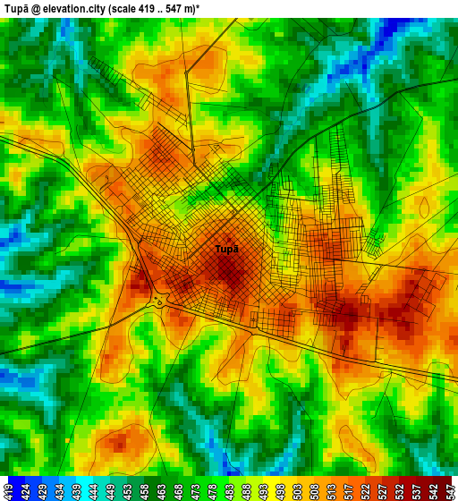
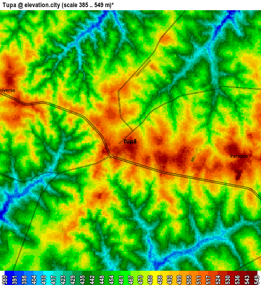
Below is the Elevation map of Tupã, which displays elevation range with different colors. Scale of the first map is from 419 to 547 m (1375 to 1795 ft) with average elevation of 484.7 meters (=1590 ft) [note 1]
These maps also provides idea of topography and contour of this city, they are displayed at different zoom levels. More info about maps, scale and edge coordinates you can find below images.
| \ | Map #1 | Map #2 | Topo.Map |
| Scale [m] | 419..547 m | 385..549 m | × |
| Scale [ft] | 1375..1795 ft | 1263..1801 ft | × |
| Average | 484.7 m = 1590 ft | 465.4 m = 1527 ft | × |
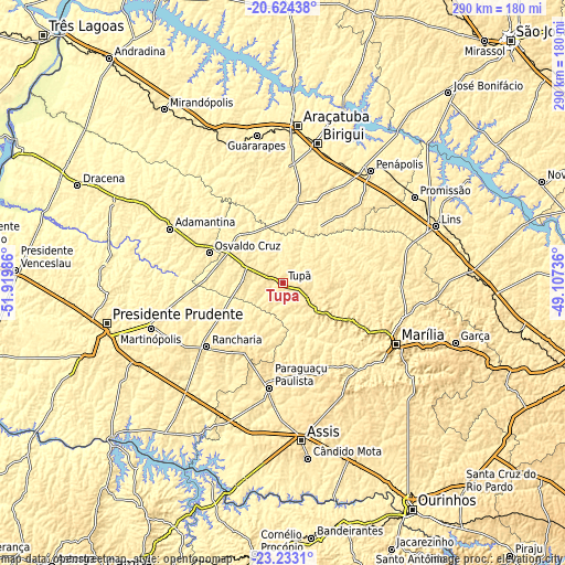
| Width | 9.07 km = 5.6 mi | 18.13 km = 11.3 mi | 290.1 km = 180.3 mi |
| Height | 9.07 km = 5.6 mi | 18.13 km = 11.3 mi | 290.1 km = 180.3 mi |
| ↑Max Latitude | -21.89395° | -21.853168° | -20.62438° |
| Latitude at center | -21.93472° | -21.93472° | -21.93472° |
| ↓Min Latitude | -21.975478° | -22.016225° | -23.2331° |
| ← Min Longitude | -50.557555° | -50.601501° | -51.91986° |
| Longitude center | -50.51361° | -50.51361° | -50.51361° |
| →Max Longitude | -50.469665° | -50.425719° | -49.10736° |
Nearby cities:
Cities around Tupã sort by population:
• Marília elevation 655 m
66.2 km,  117°
117°
• Birigui 409 m
74 km,  14°
14°
• Penápolis 414 m
72.9 km,  38°
38°
• Paraguaçu Paulista 510 m
53.5 km,  186°
186°
• Adamantina 468 m
64 km,  295°
295°
• Osvaldo Cruz 465 m
40.7 km,  292°
292°
• Rancharia 521 m
51 km,  230°
230°
• Martinópolis 501 m
71.7 km,  250°
250°
• Pompéia 601 m
40.2 km, 118°
• Bastos 460 m
22.8 km,  273°
273°
• Lucélia 453 m
57.3 km, 294°
• Quatá 553 m
39.6 km,  208°
208°
Multilingual:
 En español:
Tupã elevación 528 m.
 En France:
Tupã élévation 528 m.


Sources and notes:
- [note 1] Map square and city borders are not equal. Map elevation data is calculated only from area inside that square.
- [src 1] Elevation data from geonames database provided with same terms of usage.
- [src 2] The elevation map of Tupã is generated using elevation data from NASA's 3 arcsec (90m) resolution SRTM data.
- [src 3] Base (background) map © OpenStreetMap contributors tiles are generated by Geofabrik and OpenTopoMap.
Copyright & License:
This Tupã Elevation Map is licensed under CC BY-SA. You may reuse any part from this page, if you give a proper credit by linking to this URL:
 More info on terms of use page.