Lins elevation
Lins (São Paulo), Brazil elevation is 411 meters and Lins elevation in feet is 1348 ft above sea level [src 1]. Lins is a seat of a second-order administrative division (feature code) with elevation that is 29 meters (95 ft) bigger than average city elevation in Brazil.
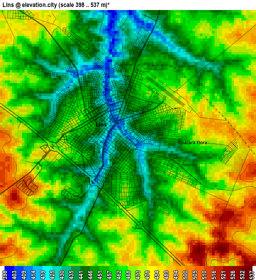
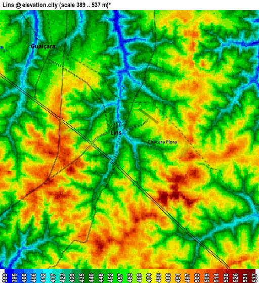
Below is the Elevation map of Lins, which displays elevation range with different colors. Scale of the first map is from 398 to 537 m (1306 to 1762 ft) with average elevation of 462.4 meters (=1517 ft) [note 1]
These maps also provides idea of topography and contour of this city, they are displayed at different zoom levels. More info about maps, scale and edge coordinates you can find below images.
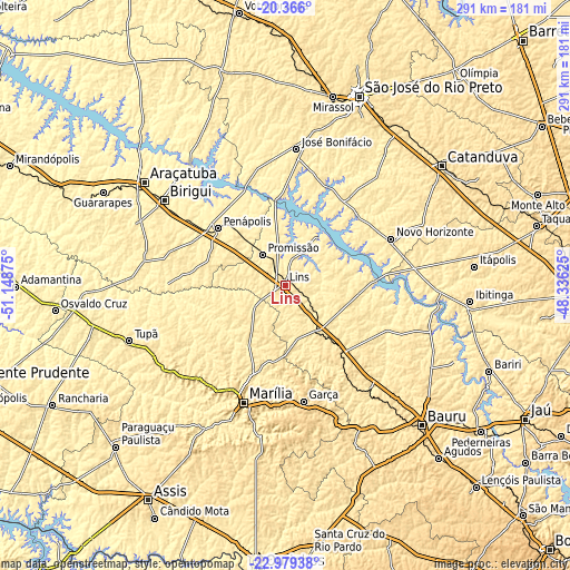
| \ | Map #1 | Map #2 | Topo.Map |
| Scale [m] | 398..537 m | 389..537 m | × |
| Scale [ft] | 1306..1762 ft | 1276..1762 ft | × |
| Average | 462.4 m = 1517 ft | 460.8 m = 1512 ft | × |
| Width | 9.08 km = 5.6 mi | 18.16 km = 11.3 mi | 290.6 km = 180.6 mi |
| Height | 9.08 km = 5.6 mi | 18.16 km = 11.3 mi | 290.6 km = 180.6 mi |
| ↑Max Latitude | -21.637767° | -21.596913° | -20.366° |
| Latitude at center | -21.67861° | -21.67861° | -21.67861° |
| ↓Min Latitude | -21.719441° | -21.760261° | -22.97938° |
| ← Min Longitude | -49.786445° | -49.830391° | -51.14875° |
| Longitude center | -49.7425° | -49.7425° | -49.7425° |
| →Max Longitude | -49.698555° | -49.654609° | -48.33625° |
Nearby cities:
Cities around Lins sort by population:
• Marília elevation 655 m
63.1 km,  199°
199°
• Birigui 409 m
75.5 km,  305°
305°
• Penápolis 414 m
45 km, 309°
• Garça 678 m
59.8 km,  171°
171°
• Novo Horizonte 453 m
58.8 km,  66°
66°
• José Bonifácio 437 m
69.8 km,  4°
4°
• Promissão 428 m
19.8 km,  322°
322°
• Pompéia 601 m
65.2 km,  222°
222°
• Pirajuí 499 m
46.2 km,  140°
140°
• Cafelândia 450 m
19.4 km, 135°
• Borborema 424 m
69.4 km,  84°
84°
• Urupês 441 m
70.7 km,  41°
41°
Multilingual:
 En español:
Lins elevación 411 m.
 En France:
Lins élévation 411 m.


Sources and notes:
- [note 1] Map square and city borders are not equal. Map elevation data is calculated only from area inside that square.
- [src 1] Elevation data from geonames database provided with same terms of usage.
- [src 2] The elevation map of Lins is generated using elevation data from NASA's 3 arcsec (90m) resolution SRTM data.
- [src 3] Base (background) map © OpenStreetMap contributors tiles are generated by Geofabrik and OpenTopoMap.
Copyright & License:
This Lins Elevation Map is licensed under CC BY-SA. You may reuse any part from this page, if you give a proper credit by linking to this URL:
 More info on terms of use page.