Urupês elevation
Urupês (São Paulo), Brazil elevation is 441 meters and Urupês elevation in feet is 1447 ft above sea level [src 1]. Urupês is a populated place (feature code) with elevation that is 59 meters (194 ft) bigger than average city elevation in Brazil.
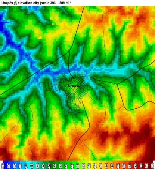
Below is the Elevation map of Urupês, which displays elevation range with different colors. Scale of the first map is from 393 to 509 m (1289 to 1670 ft) with average elevation of 450.4 meters (=1478 ft) [note 1]
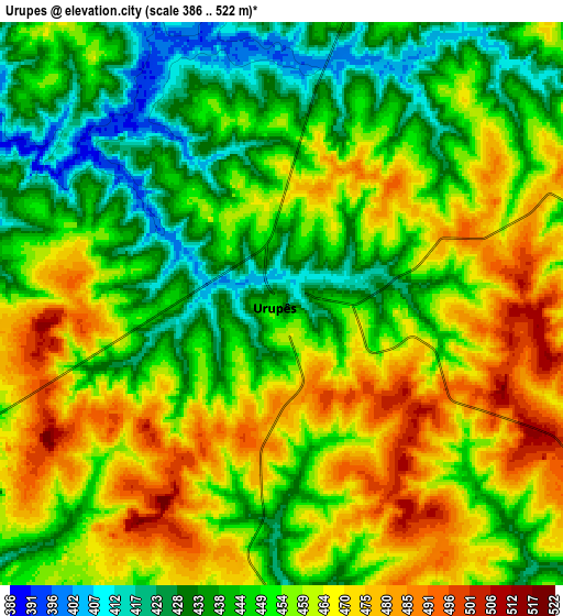
These maps also provides idea of topography and contour of this city, they are displayed at different zoom levels. More info about maps, scale and edge coordinates you can find below images.
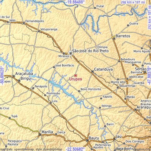
| \ | Map #1 | Map #2 | Topo.Map |
| Scale [m] | 393..509 m | 386..522 m | × |
| Scale [ft] | 1289..1670 ft | 1266..1713 ft | × |
| Average | 450.4 m = 1478 ft | 453.8 m = 1489 ft | × |
| Width | 9.11 km = 5.7 mi | 18.22 km = 11.3 mi | 291.5 km = 181.1 mi |
| Height | 9.11 km = 5.7 mi | 18.22 km = 11.3 mi | 291.5 km = 181.1 mi |
| ↑Max Latitude | -21.160694° | -21.119706° | -19.88488° |
| Latitude at center | -21.20167° | -21.20167° | -21.20167° |
| ↓Min Latitude | -21.242635° | -21.283589° | -22.50682° |
| ← Min Longitude | -49.333945° | -49.377891° | -50.69625° |
| Longitude center | -49.29° | -49.29° | -49.29° |
| →Max Longitude | -49.246055° | -49.202109° | -47.88375° |
Nearby cities:
Cities around Urupês sort by population:
• São José do Rio Preto elevation 505 m
43.5 km,  347°
347°
• Catanduva 517 m
33.6 km,  77°
77°
• Olímpia 520 m
64.7 km,  37°
37°
• Novo Horizonte 453 m
30.5 km,  166°
166°
• José Bonifácio 437 m
44.5 km,  291°
291°
• Bady Bassitt 511 m
35.4 km,  332°
332°
• Guapiaçu 508 m
45.8 km,  9°
9°
• Santa Adélia 617 m
50.6 km,  95°
95°
• Pindorama 530 m
39.7 km,  87°
87°
• Itajobi 467 m
27.6 km,  117°
117°
• Borborema 424 m
51.6 km,  154°
154°
• Paraíso 581 m
57.4 km,  68°
68°
Multilingual:
 En español:
Urupês elevación 441 m.
 En France:
Urupês élévation 441 m.


Sources and notes:
- [note 1] Map square and city borders are not equal. Map elevation data is calculated only from area inside that square.
- [src 1] Elevation data from geonames database provided with same terms of usage.
- [src 2] The elevation map of Urupês is generated using elevation data from NASA's 3 arcsec (90m) resolution SRTM data.
- [src 3] Base (background) map © OpenStreetMap contributors tiles are generated by Geofabrik and OpenTopoMap.
Copyright & License:
This Urupês Elevation Map is licensed under CC BY-SA. You may reuse any part from this page, if you give a proper credit by linking to this URL:
 More info on terms of use page.