Cambuci elevation
Cambuci (Rio de Janeiro), Brazil elevation is 53 meters and Cambuci elevation in feet is 174 ft above sea level [src 1]. Cambuci is a populated place (feature code) with elevation that is 329 meters (1079 ft) smaller than average city elevation in Brazil.
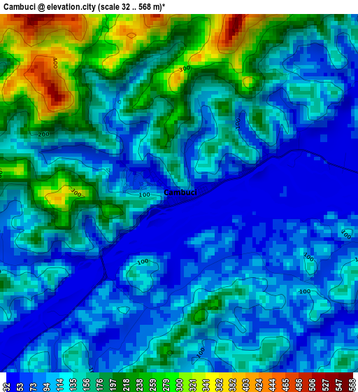
Below is the Elevation map of Cambuci, which displays elevation range with different colors. Scale of the first map is from 32 to 568 m (105 to 1864 ft) with average elevation of 139.3 meters (=457 ft) [note 1]
These maps also provides idea of topography and contour of this city, they are displayed at different zoom levels. More info about maps, scale and edge coordinates you can find below images.
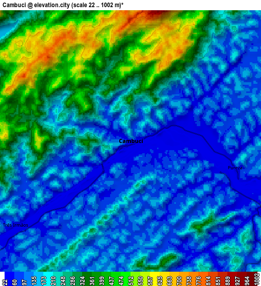
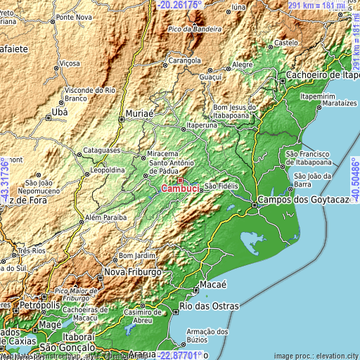
| \ | Map #1 | Map #2 | Topo.Map |
| Scale [m] | 32..568 m | 22..1002 m | × |
| Scale [ft] | 105..1864 ft | 72..3287 ft | × |
| Average | 139.3 m = 457 ft | 220 m = 722 ft | × |
| Width | 9.09 km = 5.6 mi | 18.18 km = 11.3 mi | 290.8 km = 180.7 mi |
| Height | 9.09 km = 5.6 mi | 18.18 km = 11.3 mi | 290.8 km = 180.7 mi |
| ↑Max Latitude | -21.534408° | -21.493524° | -20.26175° |
| Latitude at center | -21.57528° | -21.57528° | -21.57528° |
| ↓Min Latitude | -21.616141° | -21.65699° | -22.87701° |
| ← Min Longitude | -41.955055° | -41.999001° | -43.31736° |
| Longitude center | -41.91111° | -41.91111° | -41.91111° |
| →Max Longitude | -41.867165° | -41.823219° | -40.50486° |
Nearby cities:
Cities around Cambuci sort by population:
• Campos dos Goytacazes elevation 13 m
63.1 km,  108°
108°
• Muriaé 212 m
68.3 km,  316°
316°
• Itaperuna 123 m
41.2 km,  3°
3°
• Santo Antônio de Pádua 91 m
28.1 km,  278°
278°
• Bom Jesus do Itabapoana 90 m
54.6 km,  26°
26°
• São Fidélis 22 m
18.7 km, 114°
• Miracema 142 m
34.7 km,  301°
301°
• Itaocara 99 m
20 km,  238°
238°
• Cantagalo 431 m
65.3 km,  226°
226°
• Natividade 216 m
59.6 km,  353°
353°
• Recreio 180 m
58 km, 275°
• São José do Calçado 327 m
66.7 km,  23°
23°
Multilingual:
 En español:
Cambuci elevación 53 m.
 En France:
Cambuci élévation 53 m.


Sources and notes:
- [note 1] Map square and city borders are not equal. Map elevation data is calculated only from area inside that square.
- [src 1] Elevation data from geonames database provided with same terms of usage.
- [src 2] The elevation map of Cambuci is generated using elevation data from NASA's 3 arcsec (90m) resolution SRTM data.
- [src 3] Base (background) map © OpenStreetMap contributors tiles are generated by Geofabrik and OpenTopoMap.
Copyright & License:
This Cambuci Elevation Map is licensed under CC BY-SA. You may reuse any part from this page, if you give a proper credit by linking to this URL:
 More info on terms of use page.