Campos dos Goytacazes elevation
Campos dos Goytacazes (Rio de Janeiro), Brazil elevation is 13 meters and Campos dos Goytacazes elevation in feet is 43 ft above sea level [src 1]. Campos dos Goytacazes is a seat of a second-order administrative division (feature code) with elevation that is 369 meters (1211 ft) smaller than average city elevation in Brazil.
Below is the Elevation map of Campos dos Goytacazes, which displays elevation range with different colors. Scale of the first map is from -11 to 38 m (-36 to 125 ft) with average elevation of 10.3 meters (=34 ft) [note 1]
These maps also provides idea of topography and contour of this city, they are displayed at different zoom levels. More info about maps, scale and edge coordinates you can find below images.
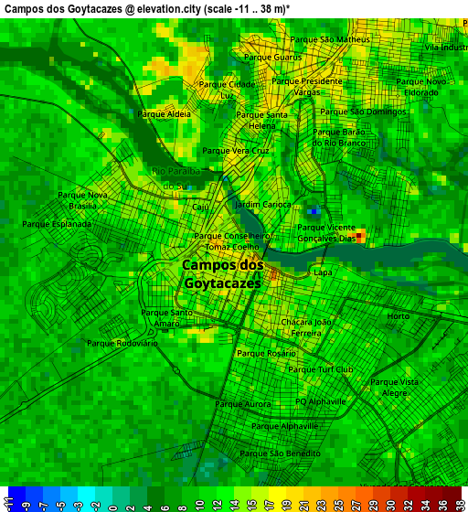
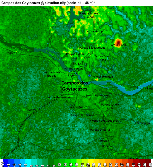
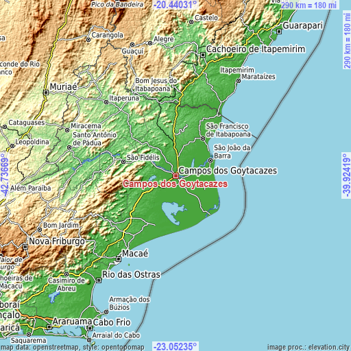
| \ | Map #1 | Map #2 | Topo.Map |
| Scale [m] | -11..38 m | -11..48 m | × |
| Scale [ft] | -36..125 ft | -36..157 ft | × |
| Average | 10.3 m = 34 ft | 9.1 m = 30 ft | × |
| Width | 9.08 km = 5.6 mi | 18.15 km = 11.3 mi | 290.4 km = 180.4 mi |
| Height | 9.08 km = 5.6 mi | 18.15 km = 11.3 mi | 290.4 km = 180.4 mi |
| ↑Max Latitude | -21.711448° | -21.670614° | -20.44031° |
| Latitude at center | -21.75227° | -21.75227° | -21.75227° |
| ↓Min Latitude | -21.79308° | -21.833879° | -23.05235° |
| ← Min Longitude | -41.374385° | -41.418331° | -42.73669° |
| Longitude center | -41.33044° | -41.33044° | -41.33044° |
| →Max Longitude | -41.286495° | -41.242549° | -39.92419° |
Nearby cities:
Cities around Campos dos Goytacazes sort by population:
• Macaé elevation 8 m
84.4 km,  213°
213°
• Itaperuna 123 m
83.8 km,  316°
316°
• Santo Antônio de Pádua 91 m
91 km,  285°
285°
• Bom Jesus do Itabapoana 90 m
77.7 km,  332°
332°
• São Fidélis 22 m
44.6 km, 285°
• Marataizes 7 m
94.6 km,  33°
33°
• São João da Barra 7 m
31.4 km,  66°
66°
• Itapemirim 9 m
97.1 km, 31°
• Itaocara 99 m
77.6 km,  276°
276°
• Mimoso do Sul 74 m
76.6 km,  357°
357°
• Cambuci 53 m
63.1 km, 288°
• São José do Calçado 327 m
87.5 km,  337°
337°
Multilingual:
 En español:
Campos dos Goytacazes elevación 13 m.
 En France:
Campos dos Goytacazes élévation 13 m.
 Auf Deutsch:
Campos dos Goytacazes höhe über dem Meeresspiegel ist 13 m.
 На русском:
Кампос, Кампус-дус-Гойтаказис высота над уровнем моря 13 м
Sources and notes:
- [note 1] Map square and city borders are not equal. Map elevation data is calculated only from area inside that square.
- [src 1] Elevation data from geonames database provided with same terms of usage.
- [src 2] The elevation map of Campos dos Goytacazes is generated using elevation data from NASA's 3 arcsec (90m) resolution SRTM data.
- [src 3] Base (background) map © OpenStreetMap contributors tiles are generated by Geofabrik and OpenTopoMap.
Copyright & License:
This Campos dos Goytacazes Elevation Map is licensed under CC BY-SA. You may reuse any part from this page, if you give a proper credit by linking to this URL:
 More info on terms of use page.