Bom Jesus do Itabapoana elevation
Bom Jesus do Itabapoana (Rio de Janeiro), Brazil elevation is 90 meters and Bom Jesus do Itabapoana elevation in feet is 295 ft above sea level [src 1]. Bom Jesus do Itabapoana is a populated place (feature code) with elevation that is 292 meters (958 ft) smaller than average city elevation in Brazil.
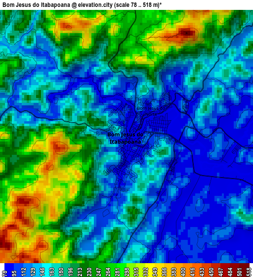
Below is the Elevation map of Bom Jesus do Itabapoana, which displays elevation range with different colors. Scale of the first map is from 78 to 518 m (256 to 1699 ft) with average elevation of 184.5 meters (=605 ft) [note 1]
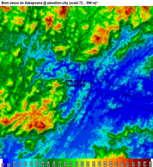
These maps also provides idea of topography and contour of this city, they are displayed at different zoom levels. More info about maps, scale and edge coordinates you can find below images.
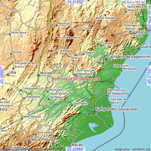
| \ | Map #1 | Map #2 | Topo.Map |
| Scale [m] | 78..518 m | 72..598 m | × |
| Scale [ft] | 256..1699 ft | 236..1962 ft | × |
| Average | 184.5 m = 605 ft | 222.3 m = 729 ft | × |
| Width | 9.12 km = 5.7 mi | 18.23 km = 11.3 mi | 291.7 km = 181.3 mi |
| Height | 9.12 km = 5.7 mi | 18.23 km = 11.3 mi | 291.7 km = 181.3 mi |
| ↑Max Latitude | -21.092895° | -21.051888° | -19.81652° |
| Latitude at center | -21.13389° | -21.13389° | -21.13389° |
| ↓Min Latitude | -21.174874° | -21.215846° | -22.43966° |
| ← Min Longitude | -41.723665° | -41.767611° | -43.08597° |
| Longitude center | -41.67972° | -41.67972° | -41.67972° |
| →Max Longitude | -41.635775° | -41.591829° | -40.27347° |
Nearby cities:
Cities around Bom Jesus do Itabapoana sort by population:
• Itaperuna elevation 123 m
23 km,  249°
249°
• São Fidélis 22 m
57.4 km,  186°
186°
• Carangola 416 m
57.5 km,  320°
320°
• Guaçuí 597 m
39.8 km,  0°
0°
• Alegre 248 m
43.9 km,  20°
20°
• Mimoso do Sul 74 m
33.4 km,  76°
76°
• Espera Feliz 767 m
58.7 km,  336°
336°
• Porciúncula 196 m
42 km,  296°
296°
• Natividade 216 m
32.1 km,  288°
288°
• Cambuci 53 m
54.6 km,  206°
206°
• São José do Calçado 327 m
12.4 km,  12°
12°
• Jerônimo Monteiro 118 m
48.4 km,  37°
37°
Multilingual:
 En español:
Bom Jesus do Itabapoana elevación 90 m.
 En France:
Bom Jesus do Itabapoana élévation 90 m.
 Auf Deutsch:
Bom Jesus do Itabapoana höhe über dem Meeresspiegel ist 90 m.
 На русском:
Бон-Жезус-ду-Итабапоана высота над уровнем моря 90 м
Sources and notes:
- [note 1] Map square and city borders are not equal. Map elevation data is calculated only from area inside that square.
- [src 1] Elevation data from geonames database provided with same terms of usage.
- [src 2] The elevation map of Bom Jesus do Itabapoana is generated using elevation data from NASA's 3 arcsec (90m) resolution SRTM data.
- [src 3] Base (background) map © OpenStreetMap contributors tiles are generated by Geofabrik and OpenTopoMap.
Copyright & License:
This Bom Jesus do Itabapoana Elevation Map is licensed under CC BY-SA. You may reuse any part from this page, if you give a proper credit by linking to this URL:
 More info on terms of use page.