Jerônimo Monteiro elevation
Jerônimo Monteiro (Espírito Santo), Brazil elevation is 118 meters and Jerônimo Monteiro elevation in feet is 387 ft above sea level [src 1]. Jerônimo Monteiro is a populated place (feature code) with elevation that is 264 meters (866 ft) smaller than average city elevation in Brazil.
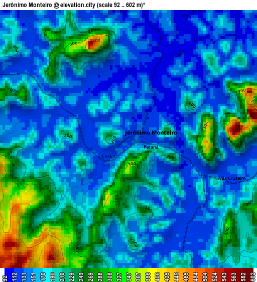
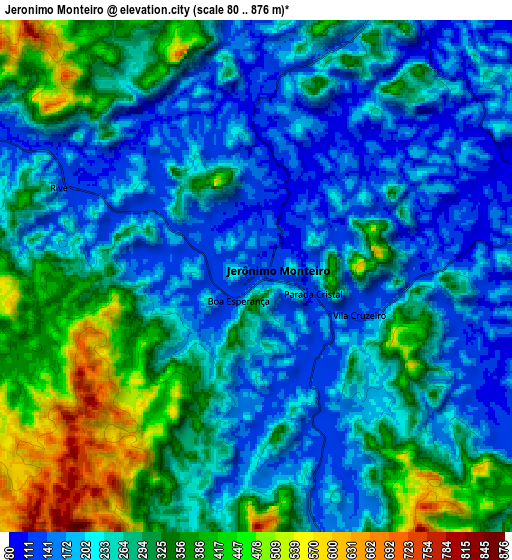
Below is the Elevation map of Jerônimo Monteiro, which displays elevation range with different colors. Scale of the first map is from 92 to 602 m (302 to 1975 ft) with average elevation of 189.1 meters (=620 ft) [note 1]
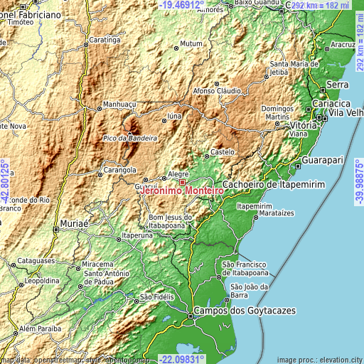
These maps also provides idea of topography and contour of this city, they are displayed at different zoom levels. More info about maps, scale and edge coordinates you can find below images.
| \ | Map #1 | Map #2 | Topo.Map |
| Scale [m] | 92..602 m | 80..876 m | × |
| Scale [ft] | 302..1975 ft | 262..2874 ft | × |
| Average | 189.1 m = 620 ft | 264.4 m = 867 ft | × |
| Width | 9.14 km = 5.7 mi | 18.27 km = 11.4 mi | 292.3 km = 181.6 mi |
| Height | 9.14 km = 5.7 mi | 18.27 km = 11.4 mi | 292.4 km = 181.7 mi |
| ↑Max Latitude | -20.74835° | -20.707249° | -19.46912° |
| Latitude at center | -20.78944° | -20.78944° | -20.78944° |
| ↓Min Latitude | -20.830518° | -20.871586° | -22.09831° |
| ← Min Longitude | -41.438945° | -41.482891° | -42.80125° |
| Longitude center | -41.395° | -41.395° | -41.395° |
| →Max Longitude | -41.351055° | -41.307109° | -39.98875° |
Nearby cities:
Cities around Jerônimo Monteiro sort by population:
• Cachoeiro de Itapemirim elevation 39 m
30.1 km,  102°
102°
• Bom Jesus do Itabapoana 90 m
48.4 km,  217°
217°
• Castelo 129 m
30.1 km,  46°
46°
• Guaçuí 597 m
29.6 km,  272°
272°
• Alegre 248 m
14.6 km,  281°
281°
• Iúna 670 m
51.5 km,  343°
343°
• Mimoso do Sul 74 m
30.7 km,  174°
174°
• Muniz Freire 555 m
36.2 km,  357°
357°
• São José do Calçado 327 m
37.6 km,  225°
225°
• Rio Novo do Sul 68 m
48.3 km, 99°
• Vargem Alta 604 m
42.4 km,  71°
71°
• Conceição do Castelo 722 m
49.4 km,  18°
18°
Multilingual:
 En español:
Jerônimo Monteiro elevación 118 m.
 En France:
Jerônimo Monteiro élévation 118 m.
 Auf Deutsch:
Jerônimo Monteiro höhe über dem Meeresspiegel ist 118 m.

Sources and notes:
- [note 1] Map square and city borders are not equal. Map elevation data is calculated only from area inside that square.
- [src 1] Elevation data from geonames database provided with same terms of usage.
- [src 2] The elevation map of Jerônimo Monteiro is generated using elevation data from NASA's 3 arcsec (90m) resolution SRTM data.
- [src 3] Base (background) map © OpenStreetMap contributors tiles are generated by Geofabrik and OpenTopoMap.
Copyright & License:
This Jerônimo Monteiro Elevation Map is licensed under CC BY-SA. You may reuse any part from this page, if you give a proper credit by linking to this URL:
 More info on terms of use page.