Espera Feliz elevation
Espera Feliz (Minas Gerais), Brazil elevation is 767 meters and Espera Feliz elevation in feet is 2516 ft above sea level [src 1]. Espera Feliz is a populated place (feature code) with elevation that is 385 meters (1263 ft) bigger than average city elevation in Brazil.
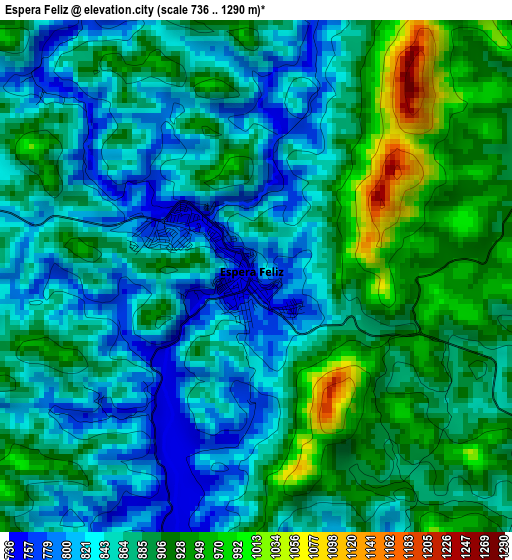
Below is the Elevation map of Espera Feliz, which displays elevation range with different colors. Scale of the first map is from 736 to 1290 m (2415 to 4232 ft) with average elevation of 876.4 meters (=2875 ft) [note 1]
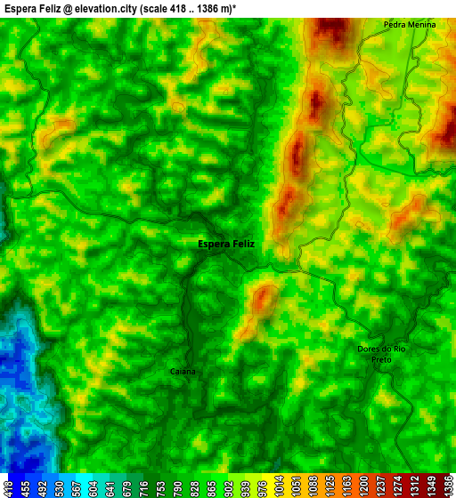
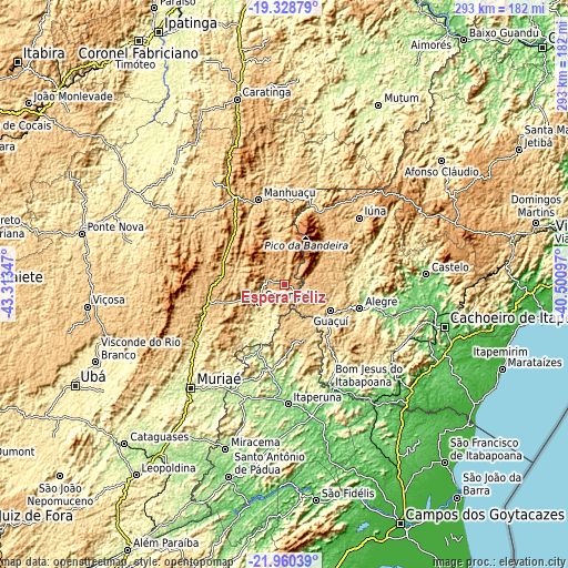
These maps also provides idea of topography and contour of this city, they are displayed at different zoom levels. More info about maps, scale and edge coordinates you can find below images.
| \ | Map #1 | Map #2 | Topo.Map |
| Scale [m] | 736..1290 m | 418..1386 m | × |
| Scale [ft] | 2415..4232 ft | 1371..4547 ft | × |
| Average | 876.4 m = 2875 ft | 865.3 m = 2839 ft | × |
| Width | 9.14 km = 5.7 mi | 18.29 km = 11.4 mi | 292.6 km = 181.8 mi |
| Height | 9.14 km = 5.7 mi | 18.29 km = 11.4 mi | 292.6 km = 181.8 mi |
| ↑Max Latitude | -20.609153° | -20.568014° | -19.32879° |
| Latitude at center | -20.65028° | -20.65028° | -20.65028° |
| ↓Min Latitude | -20.691396° | -20.732501° | -21.96039° |
| ← Min Longitude | -41.951165° | -41.995111° | -43.31347° |
| Longitude center | -41.90722° | -41.90722° | -41.90722° |
| →Max Longitude | -41.863275° | -41.819329° | -40.50097° |
Nearby cities:
Cities around Espera Feliz sort by population:
• Manhuaçu elevation 641 m
45.6 km,  343°
343°
• Carangola 416 m
15.7 km,  234°
234°
• Guaçuí 597 m
27.5 km,  120°
120°
• Alegre 248 m
40.9 km,  107°
107°
• Manhumirim 603 m
33 km,  350°
350°
• Iúna 670 m
51.4 km,  48°
48°
• Porciúncula 196 m
37.4 km,  201°
201°
• Natividade 216 m
44.1 km,  188°
188°
• Muniz Freire 555 m
55.5 km,  68°
68°
• São José do Calçado 327 m
49.3 km,  147°
147°
• Jerônimo Monteiro 118 m
55.5 km, 106°
• Irupi 747 m
43.8 km,  39°
39°
Multilingual:
 En español:
Espera Feliz elevación 767 m.
 En France:
Espera Feliz élévation 767 m.
 Auf Deutsch:
Espera Feliz höhe über dem Meeresspiegel ist 767 m.

Sources and notes:
- [note 1] Map square and city borders are not equal. Map elevation data is calculated only from area inside that square.
- [src 1] Elevation data from geonames database provided with same terms of usage.
- [src 2] The elevation map of Espera Feliz is generated using elevation data from NASA's 3 arcsec (90m) resolution SRTM data.
- [src 3] Base (background) map © OpenStreetMap contributors tiles are generated by Geofabrik and OpenTopoMap.
Copyright & License:
This Espera Feliz Elevation Map is licensed under CC BY-SA. You may reuse any part from this page, if you give a proper credit by linking to this URL:
 More info on terms of use page.