São João da Barra elevation
São João da Barra (Rio de Janeiro), Brazil elevation is 7 meters and São João da Barra elevation in feet is 23 ft above sea level [src 1]. São João da Barra is a populated place (feature code) with elevation that is 375 meters (1230 ft) smaller than average city elevation in Brazil.
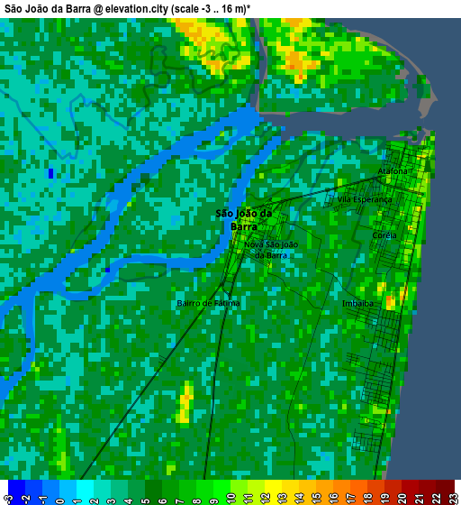
Below is the Elevation map of São João da Barra, which displays elevation range with different colors. Scale of the first map is from -3 to 16 m (-10 to 52 ft) with average elevation of 4.4 meters (=14 ft) [note 1]
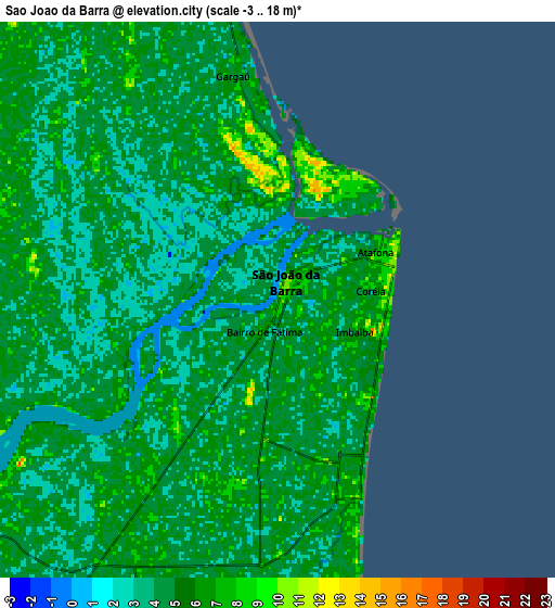
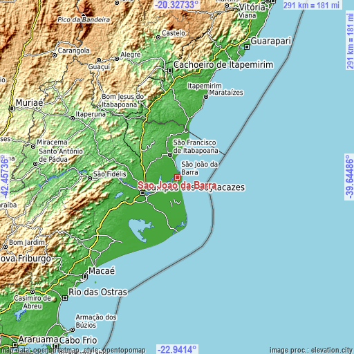
These maps also provides idea of topography and contour of this city, they are displayed at different zoom levels. More info about maps, scale and edge coordinates you can find below images.
| \ | Map #1 | Map #2 | Topo.Map |
| Scale [m] | -3..16 m | -3..18 m | × |
| Scale [ft] | -10..52 ft | -10..59 ft | × |
| Average | 4.4 m = 14 ft | 4.5 m = 15 ft | × |
| Width | 9.08 km = 5.6 mi | 18.17 km = 11.3 mi | 290.7 km = 180.6 mi |
| Height | 9.08 km = 5.6 mi | 18.17 km = 11.3 mi | 290.7 km = 180.6 mi |
| ↑Max Latitude | -21.599426° | -21.558561° | -20.32733° |
| Latitude at center | -21.64028° | -21.64028° | -21.64028° |
| ↓Min Latitude | -21.681122° | -21.721953° | -22.9414° |
| ← Min Longitude | -41.095055° | -41.139001° | -42.45736° |
| Longitude center | -41.05111° | -41.05111° | -41.05111° |
| →Max Longitude | -41.007165° | -40.963219° | -39.64486° |
Nearby cities:
Cities around São João da Barra sort by population:
• Campos dos Goytacazes elevation 13 m
31.4 km,  246°
246°
• Cachoeiro de Itapemirim 39 m
88.2 km,  355°
355°
• Bom Jesus do Itabapoana 90 m
86.1 km,  310°
310°
• São Fidélis 22 m
71.9 km,  269°
269°
• Marataizes 7 m
70.4 km,  19°
19°
• Piúma 2 m
95.5 km, 20°
• Itapemirim 9 m
73.5 km, 17°
• Mimoso do Sul 74 m
71.9 km,  332°
332°
• Cambuci 53 m
89.2 km, 274°
• São José do Calçado 327 m
92.6 km,  317°
317°
• Rio Novo do Sul 68 m
87.3 km,  7°
7°
• Iconha 29 m
97.4 km, 14°
Multilingual:
 En español:
São João da Barra elevación 7 m.
 En France:
São João da Barra élévation 7 m.
 Auf Deutsch:
São João da Barra höhe über dem Meeresspiegel ist 7 m.

Sources and notes:
- [note 1] Map square and city borders are not equal. Map elevation data is calculated only from area inside that square.
- [src 1] Elevation data from geonames database provided with same terms of usage.
- [src 2] The elevation map of São João da Barra is generated using elevation data from NASA's 3 arcsec (90m) resolution SRTM data.
- [src 3] Base (background) map © OpenStreetMap contributors tiles are generated by Geofabrik and OpenTopoMap.
Copyright & License:
This São João da Barra Elevation Map is licensed under CC BY-SA. You may reuse any part from this page, if you give a proper credit by linking to this URL:
 More info on terms of use page.