Miracema elevation
Miracema (Rio de Janeiro), Brazil elevation is 142 meters and Miracema elevation in feet is 466 ft above sea level [src 1]. Miracema is a populated place (feature code) with elevation that is 240 meters (787 ft) smaller than average city elevation in Brazil.
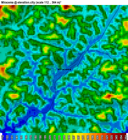
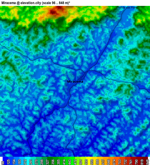
Below is the Elevation map of Miracema, which displays elevation range with different colors. Scale of the first map is from 112 to 364 m (367 to 1194 ft) with average elevation of 180.6 meters (=593 ft) [note 1]
These maps also provides idea of topography and contour of this city, they are displayed at different zoom levels. More info about maps, scale and edge coordinates you can find below images.
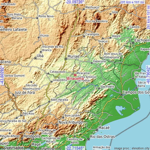
| \ | Map #1 | Map #2 | Topo.Map |
| Scale [m] | 112..364 m | 96..848 m | × |
| Scale [ft] | 367..1194 ft | 315..2782 ft | × |
| Average | 180.6 m = 593 ft | 224.1 m = 735 ft | × |
| Width | 9.1 km = 5.7 mi | 18.2 km = 11.3 mi | 291.1 km = 180.9 mi |
| Height | 9.1 km = 5.7 mi | 18.2 km = 11.3 mi | 291.1 km = 180.9 mi |
| ↑Max Latitude | -21.371302° | -21.330373° | -20.09726° |
| Latitude at center | -21.41222° | -21.41222° | -21.41222° |
| ↓Min Latitude | -21.453126° | -21.494021° | -22.71545° |
| ← Min Longitude | -42.240615° | -42.284561° | -43.60292° |
| Longitude center | -42.19667° | -42.19667° | -42.19667° |
| →Max Longitude | -42.152725° | -42.108779° | -40.79042° |
Nearby cities:
Cities around Miracema sort by population:
• Muriaé elevation 212 m
35.9 km,  330°
330°
• Itaperuna 123 m
39.4 km,  54°
54°
• Cataguases 180 m
51.8 km,  272°
272°
• Leopoldina 250 m
48.1 km,  253°
253°
• Santo Antônio de Pádua 91 m
14.2 km,  173°
173°
• São Fidélis 22 m
53.3 km,  119°
119°
• Itaocara 99 m
31.2 km,  156°
156°
• Porciúncula 196 m
52.5 km,  17°
17°
• Natividade 216 m
47.2 km,  29°
29°
• Cambuci 53 m
34.7 km, 121°
• Recreio 180 m
30.9 km, 246°
• Miraí 343 m
49.5 km,  299°
299°
Multilingual:
 En español:
Miracema elevación 142 m.
 En France:
Miracema élévation 142 m.
 Auf Deutsch:
Miracema höhe über dem Meeresspiegel ist 142 m.

Sources and notes:
- [note 1] Map square and city borders are not equal. Map elevation data is calculated only from area inside that square.
- [src 1] Elevation data from geonames database provided with same terms of usage.
- [src 2] The elevation map of Miracema is generated using elevation data from NASA's 3 arcsec (90m) resolution SRTM data.
- [src 3] Base (background) map © OpenStreetMap contributors tiles are generated by Geofabrik and OpenTopoMap.
Copyright & License:
This Miracema Elevation Map is licensed under CC BY-SA. You may reuse any part from this page, if you give a proper credit by linking to this URL:
 More info on terms of use page.