Muriaé elevation
Muriaé (Minas Gerais), Brazil elevation is 212 meters and Muriaé elevation in feet is 696 ft above sea level [src 1]. Muriaé is a populated place (feature code) with elevation that is 170 meters (558 ft) smaller than average city elevation in Brazil.
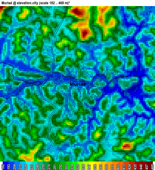
Below is the Elevation map of Muriaé, which displays elevation range with different colors. Scale of the first map is from 182 to 468 m (597 to 1535 ft) with average elevation of 249.6 meters (=819 ft) [note 1]
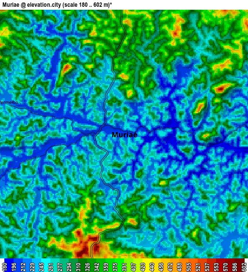
These maps also provides idea of topography and contour of this city, they are displayed at different zoom levels. More info about maps, scale and edge coordinates you can find below images.
| \ | Map #1 | Map #2 | Topo.Map |
| Scale [m] | 182..468 m | 180..602 m | × |
| Scale [ft] | 597..1535 ft | 591..1975 ft | × |
| Average | 249.6 m = 819 ft | 280.8 m = 921 ft | × |
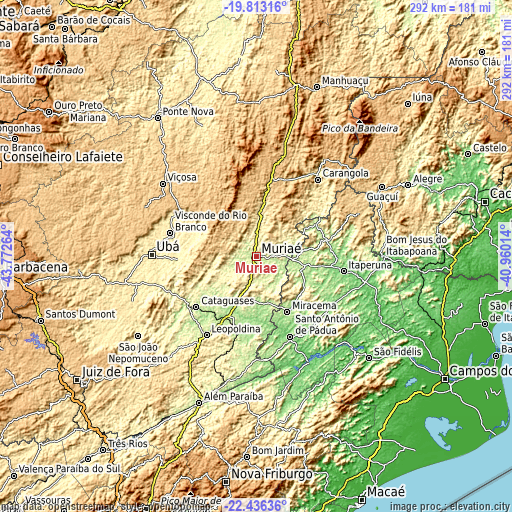
| Width | 9.12 km = 5.7 mi | 18.23 km = 11.3 mi | 291.7 km = 181.3 mi |
| Height | 9.12 km = 5.7 mi | 18.23 km = 11.3 mi | 291.7 km = 181.3 mi |
| ↑Max Latitude | -21.089564° | -21.048556° | -19.81316° |
| Latitude at center | -21.13056° | -21.13056° | -21.13056° |
| ↓Min Latitude | -21.171545° | -21.212518° | -22.43636° |
| ← Min Longitude | -42.410335° | -42.454281° | -43.77264° |
| Longitude center | -42.36639° | -42.36639° | -42.36639° |
| →Max Longitude | -42.322445° | -42.278499° | -40.96014° |
Nearby cities:
Cities around Muriaé sort by population:
• Itaperuna elevation 123 m
50.3 km,  99°
99°
• Cataguases 180 m
44.7 km,  229°
229°
• Leopoldina 250 m
53 km,  212°
212°
• Santo Antônio de Pádua 91 m
49.4 km,  157°
157°
• Visconde do Rio Branco 343 m
51 km,  285°
285°
• Miracema 142 m
35.9 km,  150°
150°
• Carangola 416 m
56.4 km,  38°
38°
• Porciúncula 196 m
38.6 km,  61°
61°
• Natividade 216 m
41.9 km,  76°
76°
• Astolfo Dutra 256 m
55.3 km,  248°
248°
• Recreio 180 m
45.1 km,  193°
193°
• Miraí 343 m
26.7 km, 254°
Multilingual:
 En español:
Muriaé elevación 212 m.
 En France:
Muriaé élévation 212 m.


Sources and notes:
- [note 1] Map square and city borders are not equal. Map elevation data is calculated only from area inside that square.
- [src 1] Elevation data from geonames database provided with same terms of usage.
- [src 2] The elevation map of Muriaé is generated using elevation data from NASA's 3 arcsec (90m) resolution SRTM data.
- [src 3] Base (background) map © OpenStreetMap contributors tiles are generated by Geofabrik and OpenTopoMap.
Copyright & License:
This Muriaé Elevation Map is licensed under CC BY-SA. You may reuse any part from this page, if you give a proper credit by linking to this URL:
 More info on terms of use page.