Paty do Alferes elevation
Paty do Alferes (Rio de Janeiro), Brazil elevation is 599 meters and Paty do Alferes elevation in feet is 1965 ft above sea level [src 1]. Paty do Alferes is a populated place (feature code) with elevation that is 217 meters (712 ft) bigger than average city elevation in Brazil.
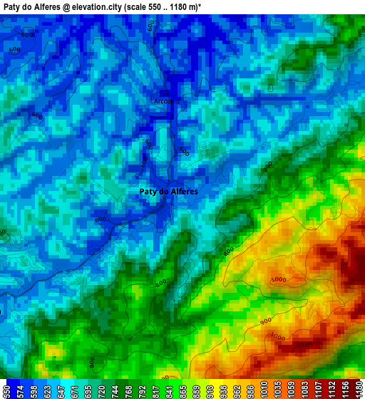
Below is the Elevation map of Paty do Alferes, which displays elevation range with different colors. Scale of the first map is from 550 to 1180 m (1804 to 3871 ft) with average elevation of 729.8 meters (=2394 ft) [note 1]
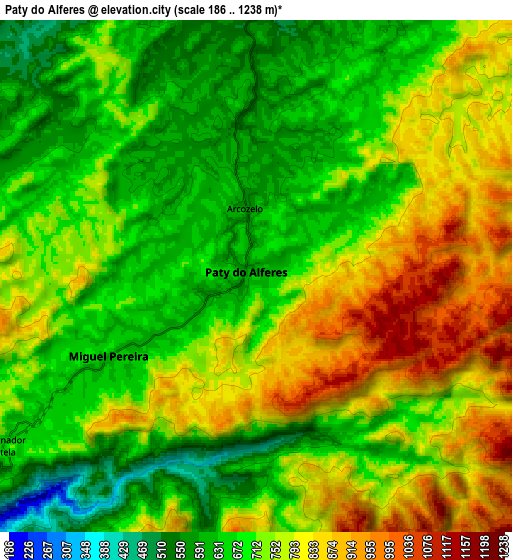
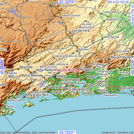
These maps also provides idea of topography and contour of this city, they are displayed at different zoom levels. More info about maps, scale and edge coordinates you can find below images.
| \ | Map #1 | Map #2 | Topo.Map |
| Scale [m] | 550..1180 m | 186..1238 m | × |
| Scale [ft] | 1804..3871 ft | 610..4062 ft | × |
| Average | 729.8 m = 2394 ft | 729.1 m = 2392 ft | × |
| Width | 9.03 km = 5.6 mi | 18.07 km = 11.2 mi | 289 km = 179.6 mi |
| Height | 9.03 km = 5.6 mi | 18.07 km = 11.2 mi | 289.1 km = 179.6 mi |
| ↑Max Latitude | -22.387983° | -22.347344° | -21.12274° |
| Latitude at center | -22.42861° | -22.42861° | -22.42861° |
| ↓Min Latitude | -22.469225° | -22.509828° | -23.72231° |
| ← Min Longitude | -43.462555° | -43.506501° | -44.82486° |
| Longitude center | -43.41861° | -43.41861° | -43.41861° |
| →Max Longitude | -43.374665° | -43.330719° | -42.01236° |
Nearby cities:
Cities around Paty do Alferes sort by population:
• Nova Iguaçu elevation 36 m
36.9 km,  185°
185°
• Belford Roxo 22 m
37.4 km,  176°
176°
• Petrópolis 819 m
26.1 km,  109°
109°
• Queimados 37 m
34.9 km,  203°
203°
• Japeri 32 m
33.9 km,  225°
225°
• Valença 560 m
35.4 km,  305°
305°
• Paracambi 51 m
35.8 km,  236°
236°
• Paraíba do Sul 323 m
32.7 km,  23°
23°
• Miguel Pereira 615 m
5.9 km, 241°
• Vassouras 424 m
25.2 km,  276°
276°
• Mendes 419 m
34.1 km,  251°
251°
• Areal 496 m
39 km,  55°
55°
Multilingual:
 En español:
Paty do Alferes elevación 599 m.
 En France:
Paty do Alferes élévation 599 m.
 Auf Deutsch:
Paty do Alferes höhe über dem Meeresspiegel ist 599 m.

Sources and notes:
- [note 1] Map square and city borders are not equal. Map elevation data is calculated only from area inside that square.
- [src 1] Elevation data from geonames database provided with same terms of usage.
- [src 2] The elevation map of Paty do Alferes is generated using elevation data from NASA's 3 arcsec (90m) resolution SRTM data.
- [src 3] Base (background) map © OpenStreetMap contributors tiles are generated by Geofabrik and OpenTopoMap.
Copyright & License:
This Paty do Alferes Elevation Map is licensed under CC BY-SA. You may reuse any part from this page, if you give a proper credit by linking to this URL:
 More info on terms of use page.