Petrópolis elevation
Petrópolis (Rio de Janeiro), Brazil elevation is 819 meters and Petrópolis elevation in feet is 2687 ft above sea level [src 1]. Petrópolis is a populated place (feature code) with elevation that is 437 meters (1434 ft) bigger than average city elevation in Brazil.
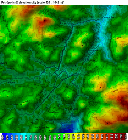
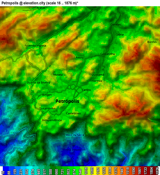
Below is the Elevation map of Petrópolis, which displays elevation range with different colors. Scale of the first map is from 526 to 1642 m (1726 to 5387 ft) with average elevation of 973.8 meters (=3195 ft) [note 1]
These maps also provides idea of topography and contour of this city, they are displayed at different zoom levels. More info about maps, scale and edge coordinates you can find below images.
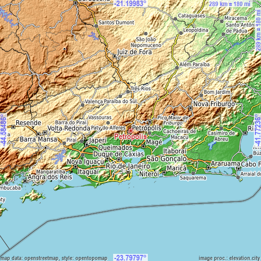
| \ | Map #1 | Map #2 | Topo.Map |
| Scale [m] | 526..1642 m | 16..1876 m | × |
| Scale [ft] | 1726..5387 ft | 52..6155 ft | × |
| Average | 973.8 m = 3195 ft | 869.9 m = 2854 ft | × |
| Width | 9.03 km = 5.6 mi | 18.06 km = 11.2 mi | 288.9 km = 179.5 mi |
| Height | 9.03 km = 5.6 mi | 18.06 km = 11.2 mi | 288.9 km = 179.5 mi |
| ↑Max Latitude | -22.464395° | -22.423779° | -21.19983° |
| Latitude at center | -22.505° | -22.505° | -22.505° |
| ↓Min Latitude | -22.545593° | -22.586174° | -23.79797° |
| ← Min Longitude | -43.222555° | -43.266501° | -44.58486° |
| Longitude center | -43.17861° | -43.17861° | -43.17861° |
| →Max Longitude | -43.134665° | -43.090719° | -41.77236° |
Nearby cities:
Cities around Petrópolis sort by population:
• Nova Iguaçu elevation 36 m
39.8 km,  224°
224°
• Duque de Caxias 15 m
34.1 km,  203°
203°
• Belford Roxo 22 m
36.7 km, 218°
• São João de Meriti 14 m
38.7 km,  210°
210°
• Teresópolis 936 m
22.8 km,  64°
64°
• Paraíba do Sul 323 m
40.3 km,  342°
342°
• Guapimirim 33 m
20.5 km,  100°
100°
• Miguel Pereira 615 m
30.4 km,  280°
280°
• Paty do Alferes 599 m
26.1 km,  289°
289°
• São Pedro 920 m
23.7 km,  67°
67°
• Areal 496 m
31.4 km,  13°
13°
• São Gonçalo 21 m
38 km,  160°
160°
Multilingual:
 En español:
Petrópolis elevación 819 m.
 En France:
Petrópolis élévation 819 m.
 Auf Deutsch:
Petrópolis höhe über dem Meeresspiegel ist 819 m.

Sources and notes:
- [note 1] Map square and city borders are not equal. Map elevation data is calculated only from area inside that square.
- [src 1] Elevation data from geonames database provided with same terms of usage.
- [src 2] The elevation map of Petrópolis is generated using elevation data from NASA's 3 arcsec (90m) resolution SRTM data.
- [src 3] Base (background) map © OpenStreetMap contributors tiles are generated by Geofabrik and OpenTopoMap.
Copyright & License:
This Petrópolis Elevation Map is licensed under CC BY-SA. You may reuse any part from this page, if you give a proper credit by linking to this URL:
 More info on terms of use page.