São Gonçalo elevation
São Gonçalo (Rio de Janeiro), Brazil elevation is 21 meters and São Gonçalo elevation in feet is 69 ft above sea level [src 1]. São Gonçalo is a seat of a second-order administrative division (feature code) with elevation that is 361 meters (1184 ft) smaller than average city elevation in Brazil.
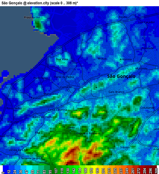
Below is the Elevation map of São Gonçalo, which displays elevation range with different colors. Scale of the first map is from 0 to 308 m (0 to 1010 ft) with average elevation of 47.5 meters (=156 ft) [note 1]
These maps also provides idea of topography and contour of this city, they are displayed at different zoom levels. More info about maps, scale and edge coordinates you can find below images.
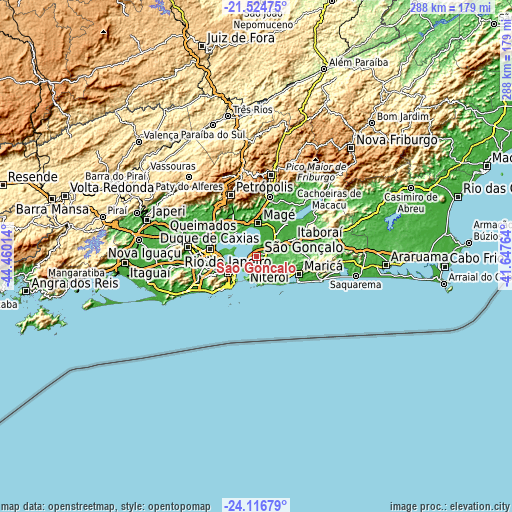
| \ | Map #1 | Topo.Map |
| Scale [m] | 0..308 m | × |
| Scale [ft] | 0..1010 ft | × |
| Average | 47.5 m = 156 ft | × |
| Width | 9.01 km = 5.6 mi | 288.2 km = 179.1 mi |
| Height | 9.01 km = 5.6 mi | 288.2 km = 179.1 mi |
| ↑Max Latitude | -22.78643° | -21.52475° |
| Latitude at center | -22.82694° | -22.82694° |
| ↓Min Latitude | -22.867438° | -24.11679° |
| ← Min Longitude | -43.097835° | -44.46014° |
| Longitude center | -43.05389° | -43.05389° |
| →Max Longitude | -43.009945° | -41.64764° |
Nearby cities:
Cities around São Gonçalo sort by population:
• Rio de Janeiro elevation 6 m
15.8 km,  236°
236°
• Nova Iguaçu 36 m
41.4 km,  280°
280°
• Duque de Caxias 15 m
26.8 km, 279°
• Belford Roxo 22 m
36.1 km, 281°
• Niterói 44 m
8.1 km,  219°
219°
• São João de Meriti 14 m
32.7 km,  274°
274°
• Petrópolis 819 m
38 km,  340°
340°
• Itaboraí 47 m
21.9 km,  65°
65°
• Nilópolis 27 m
37 km, 273°
• Maricá 10 m
26.2 km,  113°
113°
• Guapimirim 33 m
33 km,  12°
12°
• Tanguá 30 m
36.4 km, 72°
Multilingual:
 En español:
São Gonçalo elevación 21 m.
 En France:
São Gonçalo élévation 21 m.
 Auf Deutsch:
São Gonçalo höhe über dem Meeresspiegel ist 21 m.

Sources and notes:
- [note 1] Map square and city borders are not equal. Map elevation data is calculated only from area inside that square.
- [src 1] Elevation data from geonames database provided with same terms of usage.
- [src 2] The elevation map of São Gonçalo is generated using elevation data from NASA's 3 arcsec (90m) resolution SRTM data.
- [src 3] Base (background) map © OpenStreetMap contributors tiles are generated by Geofabrik and OpenTopoMap.
Copyright & License:
This São Gonçalo Elevation Map is licensed under CC BY-SA. You may reuse any part from this page, if you give a proper credit by linking to this URL:
 More info on terms of use page.