Tanguá elevation
Tanguá (Rio de Janeiro), Brazil elevation is 30 meters and Tanguá elevation in feet is 98 ft above sea level [src 1]. Tanguá is a populated place (feature code) with elevation that is 352 meters (1155 ft) smaller than average city elevation in Brazil.
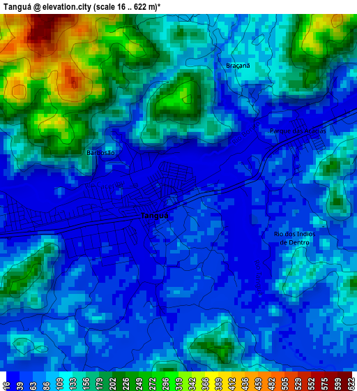
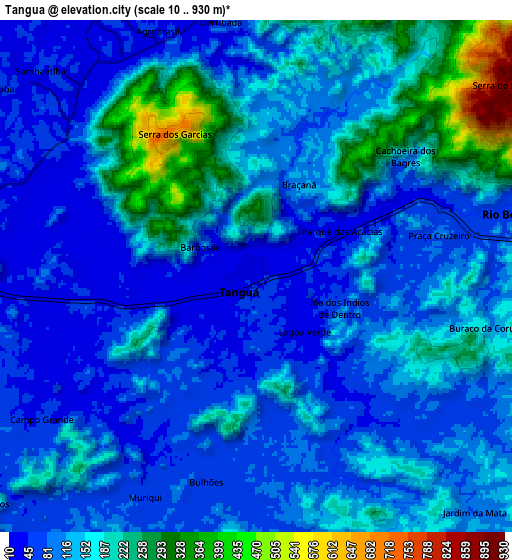
Below is the Elevation map of Tanguá, which displays elevation range with different colors. Scale of the first map is from 16 to 622 m (52 to 2041 ft) with average elevation of 114.4 meters (=375 ft) [note 1]
These maps also provides idea of topography and contour of this city, they are displayed at different zoom levels. More info about maps, scale and edge coordinates you can find below images.
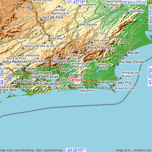
| \ | Map #1 | Map #2 | Topo.Map |
| Scale [m] | 16..622 m | 10..930 m | × |
| Scale [ft] | 52..2041 ft | 33..3051 ft | × |
| Average | 114.4 m = 375 ft | 130.9 m = 429 ft | × |
| Width | 9.01 km = 5.6 mi | 18.03 km = 11.2 mi | 288.4 km = 179.2 mi |
| Height | 9.01 km = 5.6 mi | 18.03 km = 11.2 mi | 288.4 km = 179.2 mi |
| ↑Max Latitude | -22.689742° | -22.649191° | -21.42719° |
| Latitude at center | -22.73028° | -22.73028° | -22.73028° |
| ↓Min Latitude | -22.770806° | -22.81132° | -24.02107° |
| ← Min Longitude | -42.758115° | -42.802061° | -44.12042° |
| Longitude center | -42.71417° | -42.71417° | -42.71417° |
| →Max Longitude | -42.670225° | -42.626279° | -41.30792° |
Nearby cities:
Cities around Tanguá sort by population:
• Niterói elevation 44 m
43.4 km,  246°
246°
• Itaboraí 47 m
15 km,  263°
263°
• Teresópolis 936 m
44.2 km,  322°
322°
• Araruama 20 m
41.2 km,  112°
112°
• Maricá 10 m
23.6 km,  206°
206°
• Saquarema 2 m
29.7 km,  135°
135°
• Cachoeiras de Macacu 63 m
30.4 km,  11°
11°
• Rio Bonito 67 m
11 km,  77°
77°
• Guapimirim 33 m
34.9 km,  307°
307°
• São Pedro 920 m
42.8 km, 322°
• Silva Jardim 19 m
34.2 km, 75°
• São Gonçalo 21 m
36.4 km, 252°
Multilingual:
 En español:
Tanguá elevación 30 m.
 En France:
Tanguá élévation 30 m.


Sources and notes:
- [note 1] Map square and city borders are not equal. Map elevation data is calculated only from area inside that square.
- [src 1] Elevation data from geonames database provided with same terms of usage.
- [src 2] The elevation map of Tanguá is generated using elevation data from NASA's 3 arcsec (90m) resolution SRTM data.
- [src 3] Base (background) map © OpenStreetMap contributors tiles are generated by Geofabrik and OpenTopoMap.
Copyright & License:
This Tanguá Elevation Map is licensed under CC BY-SA. You may reuse any part from this page, if you give a proper credit by linking to this URL:
 More info on terms of use page.