Queimados elevation
Queimados (Rio de Janeiro), Brazil elevation is 37 meters and Queimados elevation in feet is 121 ft above sea level [src 1]. Queimados is a populated place (feature code) with elevation that is 345 meters (1132 ft) smaller than average city elevation in Brazil.
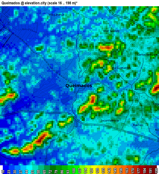
Below is the Elevation map of Queimados, which displays elevation range with different colors. Scale of the first map is from 16 to 198 m (52 to 650 ft) with average elevation of 49.4 meters (=162 ft) [note 1]
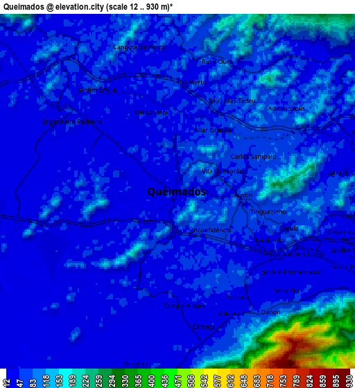
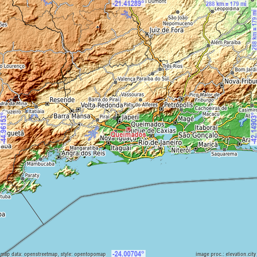
These maps also provides idea of topography and contour of this city, they are displayed at different zoom levels. More info about maps, scale and edge coordinates you can find below images.
| \ | Map #1 | Map #2 | Topo.Map |
| Scale [m] | 16..198 m | 12..930 m | × |
| Scale [ft] | 52..650 ft | 39..3051 ft | × |
| Average | 49.4 m = 162 ft | 72.1 m = 237 ft | × |
| Width | 9.01 km = 5.6 mi | 18.03 km = 11.2 mi | 288.4 km = 179.2 mi |
| Height | 9.01 km = 5.6 mi | 18.03 km = 11.2 mi | 288.5 km = 179.3 mi |
| ↑Max Latitude | -22.675568° | -22.635013° | -21.41289° |
| Latitude at center | -22.71611° | -22.71611° | -22.71611° |
| ↓Min Latitude | -22.75664° | -22.797159° | -24.00704° |
| ← Min Longitude | -43.599225° | -43.643171° | -44.96153° |
| Longitude center | -43.55528° | -43.55528° | -43.55528° |
| →Max Longitude | -43.511335° | -43.467389° | -42.14903° |
Nearby cities:
Cities around Queimados sort by population:
• Nova Iguaçu elevation 36 m
11.7 km,  114°
114°
• Duque de Caxias 15 m
26.1 km, 107°
• Belford Roxo 22 m
16.9 km, 108°
• São João de Meriti 14 m
21.2 km,  117°
117°
• Nilópolis 27 m
17.7 km,  125°
125°
• Itaguaí 31 m
27.2 km,  236°
236°
• Japeri 32 m
12.9 km,  308°
308°
• Seropédica 40 m
15.9 km,  258°
258°
• Paracambi 51 m
19.8 km, 307°
• Miguel Pereira 615 m
30.5 km,  16°
16°
• Paty do Alferes 599 m
34.9 km, 23°
• Mendes 419 m
27.8 km,  319°
319°
Multilingual:
 En español:
Queimados elevación 37 m.
 En France:
Queimados élévation 37 m.
 Auf Deutsch:
Queimados höhe über dem Meeresspiegel ist 37 m.

Sources and notes:
- [note 1] Map square and city borders are not equal. Map elevation data is calculated only from area inside that square.
- [src 1] Elevation data from geonames database provided with same terms of usage.
- [src 2] The elevation map of Queimados is generated using elevation data from NASA's 3 arcsec (90m) resolution SRTM data.
- [src 3] Base (background) map © OpenStreetMap contributors tiles are generated by Geofabrik and OpenTopoMap.
Copyright & License:
This Queimados Elevation Map is licensed under CC BY-SA. You may reuse any part from this page, if you give a proper credit by linking to this URL:
 More info on terms of use page.