Valença elevation
Valença (Rio de Janeiro), Brazil elevation is 560 meters and Valença elevation in feet is 1837 ft above sea level [src 1]. Valença is a populated place (feature code) with elevation that is 178 meters (584 ft) bigger than average city elevation in Brazil.
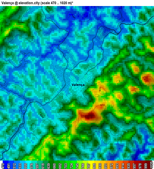
Below is the Elevation map of Valença, which displays elevation range with different colors. Scale of the first map is from 470 to 1020 m (1542 to 3346 ft) with average elevation of 609.7 meters (=2000 ft) [note 1]
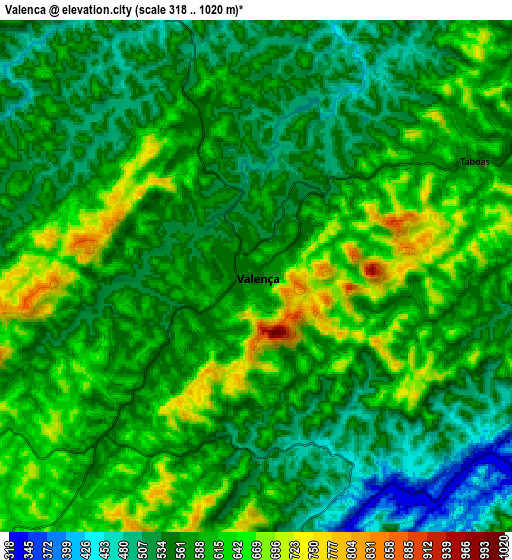
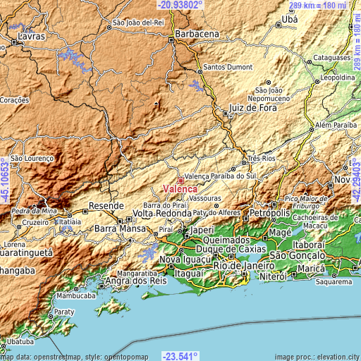
These maps also provides idea of topography and contour of this city, they are displayed at different zoom levels. More info about maps, scale and edge coordinates you can find below images.
| \ | Map #1 | Map #2 | Topo.Map |
| Scale [m] | 470..1020 m | 318..1020 m | × |
| Scale [ft] | 1542..3346 ft | 1043..3346 ft | × |
| Average | 609.7 m = 2000 ft | 580.9 m = 1906 ft | × |
| Width | 9.05 km = 5.6 mi | 18.09 km = 11.2 mi | 289.4 km = 179.8 mi |
| Height | 9.05 km = 5.6 mi | 18.09 km = 11.2 mi | 289.4 km = 179.8 mi |
| ↑Max Latitude | -22.20488° | -22.164187° | -20.93802° |
| Latitude at center | -22.24556° | -22.24556° | -22.24556° |
| ↓Min Latitude | -22.286229° | -22.326885° | -23.541° |
| ← Min Longitude | -43.744225° | -43.788171° | -45.10653° |
| Longitude center | -43.70028° | -43.70028° | -43.70028° |
| →Max Longitude | -43.656335° | -43.612389° | -42.29403° |
Nearby cities:
Cities around Valença sort by population:
• Volta Redonda elevation 400 m
51.7 km,  233°
233°
• Japeri 32 m
44.5 km,  173°
173°
• Barra do Piraí 366 m
28.1 km,  207°
207°
• Paracambi 51 m
40.3 km,  181°
181°
• Paraíba do Sul 323 m
43 km,  76°
76°
• Miguel Pereira 615 m
33.2 km,  134°
134°
• Vassouras 424 m
18 km, 167°
• Paty do Alferes 599 m
35.4 km, 125°
• Pinheiral 375 m
42.8 km, 226°
• Piraí 381 m
47.2 km, 205°
• Mendes 419 m
31.4 km,  186°
186°
• Lima Duarte 758 m
45.8 km,  347°
347°
Multilingual:
 En español:
Valença elevación 560 m.
 En France:
Valença élévation 560 m.


Sources and notes:
- [note 1] Map square and city borders are not equal. Map elevation data is calculated only from area inside that square.
- [src 1] Elevation data from geonames database provided with same terms of usage.
- [src 2] The elevation map of Valença is generated using elevation data from NASA's 3 arcsec (90m) resolution SRTM data.
- [src 3] Base (background) map © OpenStreetMap contributors tiles are generated by Geofabrik and OpenTopoMap.
Copyright & License:
This Valença Elevation Map is licensed under CC BY-SA. You may reuse any part from this page, if you give a proper credit by linking to this URL:
 More info on terms of use page.