Lima Duarte elevation
Lima Duarte (Minas Gerais), Brazil elevation is 758 meters and Lima Duarte elevation in feet is 2487 ft above sea level [src 1]. Lima Duarte is a populated place (feature code) with elevation that is 376 meters (1234 ft) bigger than average city elevation in Brazil.
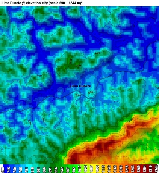
Below is the Elevation map of Lima Duarte, which displays elevation range with different colors. Scale of the first map is from 690 to 1344 m (2264 to 4409 ft) with average elevation of 834.3 meters (=2737 ft) [note 1]
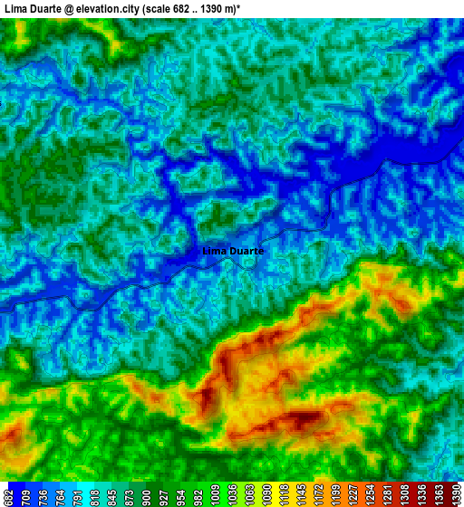
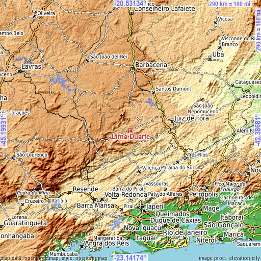
These maps also provides idea of topography and contour of this city, they are displayed at different zoom levels. More info about maps, scale and edge coordinates you can find below images.
| \ | Map #1 | Map #2 | Topo.Map |
| Scale [m] | 690..1344 m | 682..1390 m | × |
| Scale [ft] | 2264..4409 ft | 2238..4560 ft | × |
| Average | 834.3 m = 2737 ft | 880.4 m = 2888 ft | × |
| Width | 9.07 km = 5.6 mi | 18.14 km = 11.3 mi | 290.2 km = 180.3 mi |
| Height | 9.07 km = 5.6 mi | 18.14 km = 11.3 mi | 290.3 km = 180.4 mi |
| ↑Max Latitude | -21.801704° | -21.760896° | -20.53134° |
| Latitude at center | -21.8425° | -21.8425° | -21.8425° |
| ↓Min Latitude | -21.883285° | -21.924058° | -23.14174° |
| ← Min Longitude | -43.837005° | -43.880951° | -45.19931° |
| Longitude center | -43.79306° | -43.79306° | -43.79306° |
| →Max Longitude | -43.749115° | -43.705169° | -42.38681° |
Nearby cities:
Cities around Lima Duarte sort by population:
• Juiz de Fora elevation 707 m
46.5 km,  79°
79°
• Barbacena 1171 m
68.6 km,  1°
1°
• Barra do Piraí 366 m
69.9 km,  182°
182°
• Três Rios 276 m
67.5 km,  116°
116°
• Valença 560 m
45.8 km,  167°
167°
• Santos Dumont 844 m
49.6 km,  30°
30°
• Paraíba do Sul 323 m
62.4 km, 124°
• Vassouras 424 m
63.9 km, 167°
• Paty do Alferes 599 m
75.7 km,  149°
149°
• Barroso 927 m
75.3 km,  345°
345°
• Matias Barbosa 481 m
49 km,  93°
93°
• Andrelândia 964 m
54.5 km,  282°
282°
Multilingual:
 En español:
Lima Duarte elevación 758 m.
 En France:
Lima Duarte élévation 758 m.
 Auf Deutsch:
Lima Duarte höhe über dem Meeresspiegel ist 758 m.

Sources and notes:
- [note 1] Map square and city borders are not equal. Map elevation data is calculated only from area inside that square.
- [src 1] Elevation data from geonames database provided with same terms of usage.
- [src 2] The elevation map of Lima Duarte is generated using elevation data from NASA's 3 arcsec (90m) resolution SRTM data.
- [src 3] Base (background) map © OpenStreetMap contributors tiles are generated by Geofabrik and OpenTopoMap.
Copyright & License:
This Lima Duarte Elevation Map is licensed under CC BY-SA. You may reuse any part from this page, if you give a proper credit by linking to this URL:
 More info on terms of use page.