Andrelândia elevation
Andrelândia (Minas Gerais), Brazil elevation is 964 meters and Andrelândia elevation in feet is 3163 ft above sea level [src 1]. Andrelândia is a populated place (feature code) with elevation that is 582 meters (1909 ft) bigger than average city elevation in Brazil.
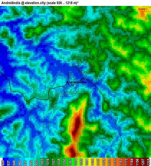
Below is the Elevation map of Andrelândia, which displays elevation range with different colors. Scale of the first map is from 926 to 1218 m (3038 to 3996 ft) with average elevation of 1000.8 meters (=3283 ft) [note 1]
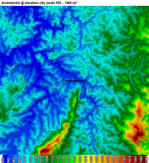
These maps also provides idea of topography and contour of this city, they are displayed at different zoom levels. More info about maps, scale and edge coordinates you can find below images.
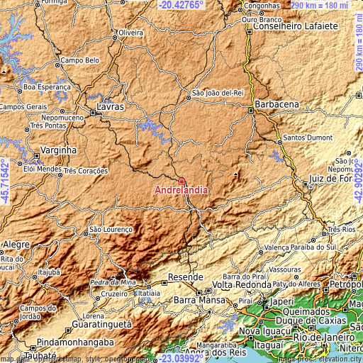
| \ | Map #1 | Map #2 | Topo.Map |
| Scale [m] | 926..1218 m | 920..1484 m | × |
| Scale [ft] | 3038..3996 ft | 3018..4869 ft | × |
| Average | 1000.8 m = 3283 ft | 1039.1 m = 3409 ft | × |
| Width | 9.08 km = 5.6 mi | 18.15 km = 11.3 mi | 290.5 km = 180.5 mi |
| Height | 9.08 km = 5.6 mi | 18.15 km = 11.3 mi | 290.5 km = 180.5 mi |
| ↑Max Latitude | -21.698894° | -21.658057° | -20.42765° |
| Latitude at center | -21.73972° | -21.73972° | -21.73972° |
| ↓Min Latitude | -21.780534° | -21.821336° | -23.03992° |
| ← Min Longitude | -44.353115° | -44.397061° | -45.71542° |
| Longitude center | -44.30917° | -44.30917° | -44.30917° |
| →Max Longitude | -44.265225° | -44.221279° | -42.90292° |
Nearby cities:
Cities around Andrelândia sort by population:
• Barbacena elevation 1171 m
79.6 km,  44°
44°
• Resende 408 m
82.3 km,  189°
189°
• São João del Rei 911 m
67.4 km,  4°
4°
• Caxambu 908 m
69.5 km,  247°
247°
• Barroso 927 m
70.5 km,  29°
29°
• Lima Duarte 758 m
54.5 km,  102°
102°
• Baependi 903 m
64.7 km, 247°
• Cruzília 1086 m
52.7 km,  257°
257°
• Conceição do Rio Verde 884 m
81.6 km, 258°
• Porto Real 392 m
75.6 km,  178°
178°
• Quatis 403 m
74.4 km, 175°
• Tiradentes 930 m
71.3 km,  10°
10°
Multilingual:
 En español:
Andrelândia elevación 964 m.
 En France:
Andrelândia élévation 964 m.
 Auf Deutsch:
Andrelândia höhe über dem Meeresspiegel ist 964 m.

Sources and notes:
- [note 1] Map square and city borders are not equal. Map elevation data is calculated only from area inside that square.
- [src 1] Elevation data from geonames database provided with same terms of usage.
- [src 2] The elevation map of Andrelândia is generated using elevation data from NASA's 3 arcsec (90m) resolution SRTM data.
- [src 3] Base (background) map © OpenStreetMap contributors tiles are generated by Geofabrik and OpenTopoMap.
Copyright & License:
This Andrelândia Elevation Map is licensed under CC BY-SA. You may reuse any part from this page, if you give a proper credit by linking to this URL:
 More info on terms of use page.