Porangatu elevation
Porangatu (Goiás), Brazil elevation is 407 meters and Porangatu elevation in feet is 1335 ft above sea level [src 1]. Porangatu is a populated place (feature code) with elevation that is 25 meters (82 ft) bigger than average city elevation in Brazil.
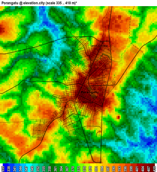
Below is the Elevation map of Porangatu, which displays elevation range with different colors. Scale of the first map is from 335 to 410 m (1099 to 1345 ft) with average elevation of 373.1 meters (=1224 ft) [note 1]
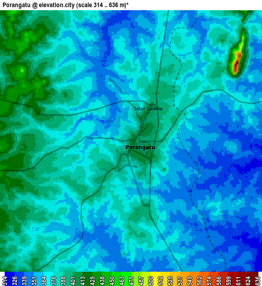
These maps also provides idea of topography and contour of this city, they are displayed at different zoom levels. More info about maps, scale and edge coordinates you can find below images.
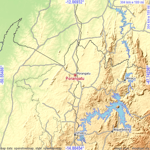
| \ | Map #1 | Map #2 | Topo.Map |
| Scale [m] | 335..410 m | 314..636 m | × |
| Scale [ft] | 1099..1345 ft | 1030..2087 ft | × |
| Average | 373.1 m = 1224 ft | 372.1 m = 1221 ft | × |
| Width | 9.5 km = 5.9 mi | 19.01 km = 11.8 mi | 304.1 km = 189 mi |
| Height | 9.5 km = 5.9 mi | 19.01 km = 11.8 mi | 304.2 km = 189 mi |
| ↑Max Latitude | -13.398085° | -13.355331° | -12.06932° |
| Latitude at center | -13.44083° | -13.44083° | -13.44083° |
| ↓Min Latitude | -13.483568° | -13.526298° | -14.80454° |
| ← Min Longitude | -49.192555° | -49.236501° | -50.55486° |
| Longitude center | -49.14861° | -49.14861° | -49.14861° |
| →Max Longitude | -49.104665° | -49.060719° | -47.74236° |
Nearby cities:
Cities around Porangatu sort by population:
• Gurupi elevation 299 m
190.5 km,  2°
2°
• Goianésia 649 m
208.7 km,  179°
179°
• Minaçu 363 m
100.9 km,  95°
95°
• Uruaçu 524 m
120.5 km, 179°
• Niquelândia 580 m
136.8 km,  147°
147°
• São Miguel do Araguaia 336 m
111.3 km,  279°
279°
• Rubiataba 638 m
204.2 km,  200°
200°
• Itapaci 555 m
173.4 km,  194°
194°
• Crixás 382 m
151.7 km,  215°
215°
• Alvorada 298 m
106.9 km, 1°
• Barro Alto 605 m
172 km,  171°
171°
• Cavalcante 810 m
186.9 km, 102°
Multilingual:
 En español:
Porangatu elevación 407 m.
 En France:
Porangatu élévation 407 m.
 Auf Deutsch:
Porangatu höhe über dem Meeresspiegel ist 407 m.

Sources and notes:
- [note 1] Map square and city borders are not equal. Map elevation data is calculated only from area inside that square.
- [src 1] Elevation data from geonames database provided with same terms of usage.
- [src 2] The elevation map of Porangatu is generated using elevation data from NASA's 3 arcsec (90m) resolution SRTM data.
- [src 3] Base (background) map © OpenStreetMap contributors tiles are generated by Geofabrik and OpenTopoMap.
Copyright & License:
This Porangatu Elevation Map is licensed under CC BY-SA. You may reuse any part from this page, if you give a proper credit by linking to this URL:
 More info on terms of use page.