Rubiataba elevation
Rubiataba (Goiás), Brazil elevation is 638 meters and Rubiataba elevation in feet is 2093 ft above sea level [src 1]. Rubiataba is a populated place (feature code) with elevation that is 256 meters (840 ft) bigger than average city elevation in Brazil.
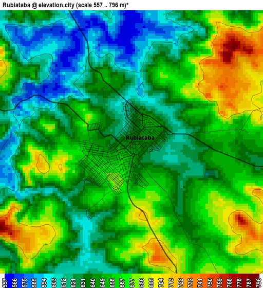
Below is the Elevation map of Rubiataba, which displays elevation range with different colors. Scale of the first map is from 557 to 796 m (1827 to 2612 ft) with average elevation of 647.4 meters (=2124 ft) [note 1]
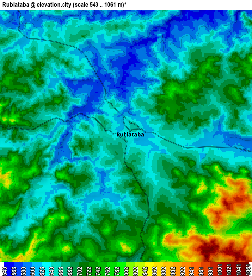
These maps also provides idea of topography and contour of this city, they are displayed at different zoom levels. More info about maps, scale and edge coordinates you can find below images.
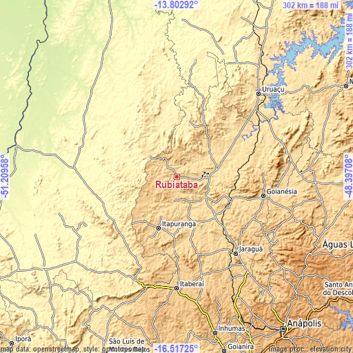
| \ | Map #1 | Map #2 | Topo.Map |
| Scale [m] | 557..796 m | 543..1061 m | × |
| Scale [ft] | 1827..2612 ft | 1781..3481 ft | × |
| Average | 647.4 m = 2124 ft | 682.7 m = 2240 ft | × |
| Width | 9.43 km = 5.9 mi | 18.86 km = 11.7 mi | 301.8 km = 187.5 mi |
| Height | 9.43 km = 5.9 mi | 18.86 km = 11.7 mi | 301.8 km = 187.5 mi |
| ↑Max Latitude | -15.122021° | -15.079593° | -13.80292° |
| Latitude at center | -15.16444° | -15.16444° | -15.16444° |
| ↓Min Latitude | -15.206851° | -15.249253° | -16.51725° |
| ← Min Longitude | -49.847275° | -49.891221° | -51.20958° |
| Longitude center | -49.80333° | -49.80333° | -49.80333° |
| →Max Longitude | -49.759385° | -49.715439° | -48.39708° |
Nearby cities:
Cities around Rubiataba sort by population:
• Goianésia elevation 649 m
75.5 km,  103°
103°
• Jaraguá 655 m
82.9 km,  142°
142°
• Itaberaí 705 m
95.2 km,  180°
180°
• Itapuranga 652 m
46.9 km,  199°
199°
• Goiás 496 m
92.9 km, 202°
• Ceres 586 m
27.2 km,  126°
126°
• Itapaci 555 m
36.2 km,  48°
48°
• Crixás 382 m
70.7 km,  345°
345°
• Mozarlândia 300 m
94.7 km,  299°
299°
• Uruana 595 m
39.9 km,  161°
161°
• Rialma 574 m
28.8 km, 125°
• Carmo do Rio Verde 611 m
23.4 km,  153°
153°
Multilingual:
 En español:
Rubiataba elevación 638 m.
 En France:
Rubiataba élévation 638 m.
 Auf Deutsch:
Rubiataba höhe über dem Meeresspiegel ist 638 m.

Sources and notes:
- [note 1] Map square and city borders are not equal. Map elevation data is calculated only from area inside that square.
- [src 1] Elevation data from geonames database provided with same terms of usage.
- [src 2] The elevation map of Rubiataba is generated using elevation data from NASA's 3 arcsec (90m) resolution SRTM data.
- [src 3] Base (background) map © OpenStreetMap contributors tiles are generated by Geofabrik and OpenTopoMap.
Copyright & License:
This Rubiataba Elevation Map is licensed under CC BY-SA. You may reuse any part from this page, if you give a proper credit by linking to this URL:
 More info on terms of use page.