Goianésia elevation
Goianésia (Goiás), Brazil elevation is 649 meters and Goianésia elevation in feet is 2129 ft above sea level [src 1]. Goianésia is a populated place (feature code) with elevation that is 267 meters (876 ft) bigger than average city elevation in Brazil.
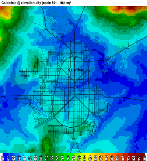
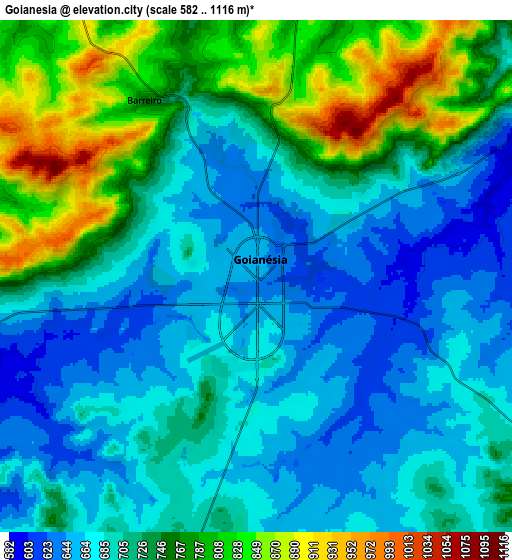
Below is the Elevation map of Goianésia, which displays elevation range with different colors. Scale of the first map is from 601 to 964 m (1972 to 3163 ft) with average elevation of 658.6 meters (=2161 ft) [note 1]
These maps also provides idea of topography and contour of this city, they are displayed at different zoom levels. More info about maps, scale and edge coordinates you can find below images.

| \ | Map #1 | Map #2 | Topo.Map |
| Scale [m] | 601..964 m | 582..1116 m | × |
| Scale [ft] | 1972..3163 ft | 1909..3661 ft | × |
| Average | 658.6 m = 2161 ft | 719.9 m = 2362 ft | × |
| Width | 9.43 km = 5.9 mi | 18.85 km = 11.7 mi | 301.6 km = 187.4 mi |
| Height | 9.43 km = 5.9 mi | 18.85 km = 11.7 mi | 301.6 km = 187.4 mi |
| ↑Max Latitude | -15.275111° | -15.232714° | -13.95693° |
| Latitude at center | -15.3175° | -15.3175° | -15.3175° |
| ↓Min Latitude | -15.35988° | -15.402251° | -16.66928° |
| ← Min Longitude | -49.161445° | -49.205391° | -50.52375° |
| Longitude center | -49.1175° | -49.1175° | -49.1175° |
| →Max Longitude | -49.073555° | -49.029609° | -47.71125° |
Nearby cities:
Cities around Goianésia sort by population:
• Jaraguá elevation 655 m
54.1 km,  205°
205°
• Uruaçu 524 m
88.2 km,  358°
358°
• Ceres 586 m
51.6 km,  271°
271°
• Rubiataba 638 m
75.5 km,  283°
283°
• Padre Bernardo 642 m
91.1 km,  79°
79°
• Itapaci 555 m
61.7 km,  311°
311°
• Pirenópolis 751 m
61.6 km,  164°
164°
• Uruana 595 m
64 km,  251°
251°
• Rialma 574 m
50.1 km, 270°
• Petrolina de Goiás 720 m
89.6 km,  195°
195°
• Barro Alto 605 m
44.2 km,  29°
29°
• Carmo do Rio Verde 611 m
63.4 km, 266°
Multilingual:
 En español:
Goianésia elevación 649 m.
 En France:
Goianésia élévation 649 m.
 Auf Deutsch:
Goianésia höhe über dem Meeresspiegel ist 649 m.

Sources and notes:
- [note 1] Map square and city borders are not equal. Map elevation data is calculated only from area inside that square.
- [src 1] Elevation data from geonames database provided with same terms of usage.
- [src 2] The elevation map of Goianésia is generated using elevation data from NASA's 3 arcsec (90m) resolution SRTM data.
- [src 3] Base (background) map © OpenStreetMap contributors tiles are generated by Geofabrik and OpenTopoMap.
Copyright & License:
This Goianésia Elevation Map is licensed under CC BY-SA. You may reuse any part from this page, if you give a proper credit by linking to this URL:
 More info on terms of use page.