Jaraguá elevation
Jaraguá (Goiás), Brazil elevation is 655 meters and Jaraguá elevation in feet is 2149 ft above sea level [src 1]. Jaraguá is a populated place (feature code) with elevation that is 273 meters (896 ft) bigger than average city elevation in Brazil.
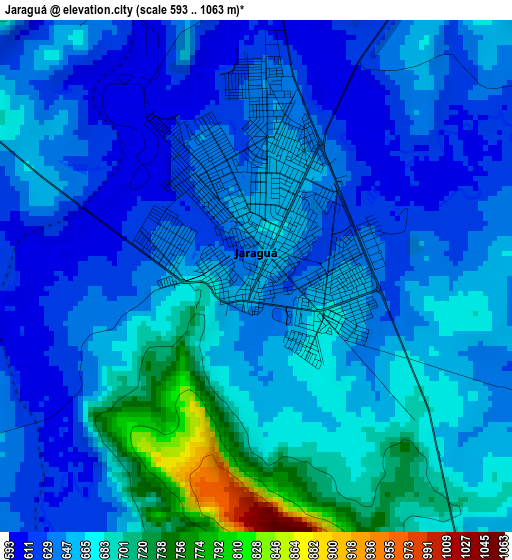
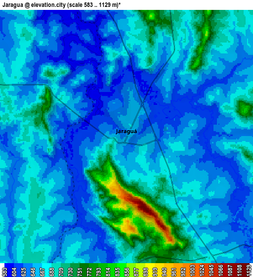
Below is the Elevation map of Jaraguá, which displays elevation range with different colors. Scale of the first map is from 593 to 1063 m (1946 to 3488 ft) with average elevation of 657.7 meters (=2158 ft) [note 1]
These maps also provides idea of topography and contour of this city, they are displayed at different zoom levels. More info about maps, scale and edge coordinates you can find below images.
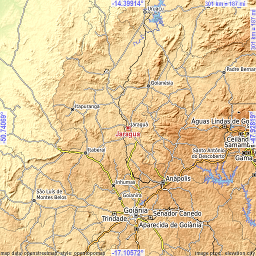
| \ | Map #1 | Map #2 | Topo.Map |
| Scale [m] | 593..1063 m | 583..1129 m | × |
| Scale [ft] | 1946..3488 ft | 1913..3704 ft | × |
| Average | 657.7 m = 2158 ft | 668.5 m = 2193 ft | × |
| Width | 9.41 km = 5.8 mi | 18.81 km = 11.7 mi | 300.9 km = 187 mi |
| Height | 9.41 km = 5.8 mi | 18.81 km = 11.7 mi | 301 km = 187 mi |
| ↑Max Latitude | -15.714642° | -15.672335° | -14.39914° |
| Latitude at center | -15.75694° | -15.75694° | -15.75694° |
| ↓Min Latitude | -15.79923° | -15.84151° | -17.10572° |
| ← Min Longitude | -49.378385° | -49.422331° | -50.74069° |
| Longitude center | -49.33444° | -49.33444° | -49.33444° |
| →Max Longitude | -49.290495° | -49.246549° | -47.92819° |
Nearby cities:
Cities around Jaraguá sort by population:
• Anápolis elevation 1003 m
75.3 km,  147°
147°
• Goianésia 649 m
54.1 km,  25°
25°
• Inhumas 763 m
69 km,  194°
194°
• Itaberaí 705 m
58.7 km,  240°
240°
• Nerópolis 822 m
73.3 km,  170°
170°
• Itapuranga 652 m
69.2 km,  288°
288°
• Ceres 586 m
57.3 km,  330°
330°
• Pirenópolis 751 m
41.3 km,  104°
104°
• Uruana 595 m
46.7 km,  307°
307°
• Rialma 574 m
56 km, 331°
• Petrolina de Goiás 720 m
37.6 km,  180°
180°
• Carmo do Rio Verde 611 m
60.1 km,  318°
318°
Multilingual:
 En español:
Jaraguá elevación 655 m.
 En France:
Jaraguá élévation 655 m.


Sources and notes:
- [note 1] Map square and city borders are not equal. Map elevation data is calculated only from area inside that square.
- [src 1] Elevation data from geonames database provided with same terms of usage.
- [src 2] The elevation map of Jaraguá is generated using elevation data from NASA's 3 arcsec (90m) resolution SRTM data.
- [src 3] Base (background) map © OpenStreetMap contributors tiles are generated by Geofabrik and OpenTopoMap.
Copyright & License:
This Jaraguá Elevation Map is licensed under CC BY-SA. You may reuse any part from this page, if you give a proper credit by linking to this URL:
 More info on terms of use page.