Gurupi elevation
Gurupi (Tocantins), Brazil elevation is 299 meters and Gurupi elevation in feet is 981 ft above sea level [src 1]. Gurupi is a populated place (feature code) with elevation that is 83 meters (272 ft) smaller than average city elevation in Brazil.
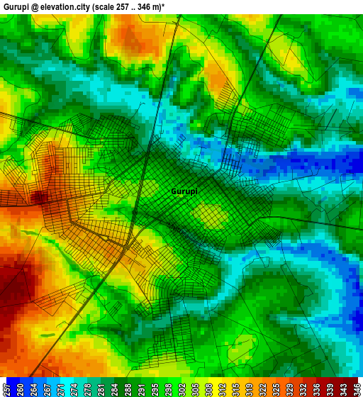
Below is the Elevation map of Gurupi, which displays elevation range with different colors. Scale of the first map is from 257 to 346 m (843 to 1135 ft) with average elevation of 295.1 meters (=968 ft) [note 1]
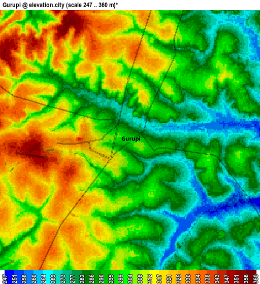
These maps also provides idea of topography and contour of this city, they are displayed at different zoom levels. More info about maps, scale and edge coordinates you can find below images.
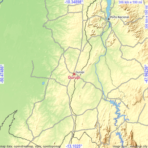
| \ | Map #1 | Map #2 | Topo.Map |
| Scale [m] | 257..346 m | 247..360 m | × |
| Scale [ft] | 843..1135 ft | 810..1181 ft | × |
| Average | 295.1 m = 968 ft | 299.9 m = 984 ft | × |
| Width | 9.57 km = 5.9 mi | 19.14 km = 11.9 mi | 306.2 km = 190.3 mi |
| Height | 9.57 km = 5.9 mi | 19.14 km = 11.9 mi | 306.2 km = 190.3 mi |
| ↑Max Latitude | -11.686139° | -11.643101° | -10.34898° |
| Latitude at center | -11.72917° | -11.72917° | -11.72917° |
| ↓Min Latitude | -11.772194° | -11.815212° | -13.1025° |
| ← Min Longitude | -49.112555° | -49.156501° | -50.47486° |
| Longitude center | -49.06861° | -49.06861° | -49.06861° |
| →Max Longitude | -49.024665° | -48.980719° | -47.66236° |
Nearby cities:
Cities around Gurupi sort by population:
• Palmas elevation 271 m
191.6 km,  24°
24°
• Porangatu 407 m
190.5 km,  182°
182°
• Minaçu 363 m
220.7 km,  155°
155°
• Uruaçu 524 m
310.9 km, 181°
• Miracema do Tocantins 195 m
251.5 km, 17°
• São Miguel do Araguaia 336 m
208.9 km,  214°
214°
• Campos Belos 629 m
288.7 km,  120°
120°
• Taguatinga 599 m
295.9 km,  104°
104°
• Arraias 695 m
267.2 km, 120°
• Alvorada 298 m
83.7 km, 184°
• Santa Terezinha 204 m
210.8 km,  311°
311°
• Cavalcante 810 m
288.8 km,  142°
142°
Multilingual:
 En español:
Gurupi elevación 299 m.
 En France:
Gurupi élévation 299 m.


Sources and notes:
- [note 1] Map square and city borders are not equal. Map elevation data is calculated only from area inside that square.
- [src 1] Elevation data from geonames database provided with same terms of usage.
- [src 2] The elevation map of Gurupi is generated using elevation data from NASA's 3 arcsec (90m) resolution SRTM data.
- [src 3] Base (background) map © OpenStreetMap contributors tiles are generated by Geofabrik and OpenTopoMap.
Copyright & License:
This Gurupi Elevation Map is licensed under CC BY-SA. You may reuse any part from this page, if you give a proper credit by linking to this URL:
 More info on terms of use page.