Taguatinga elevation
Taguatinga (Tocantins), Brazil elevation is 599 meters and Taguatinga elevation in feet is 1965 ft above sea level [src 1]. Taguatinga is a seat of a second-order administrative division (feature code) with elevation that is 217 meters (712 ft) bigger than average city elevation in Brazil.
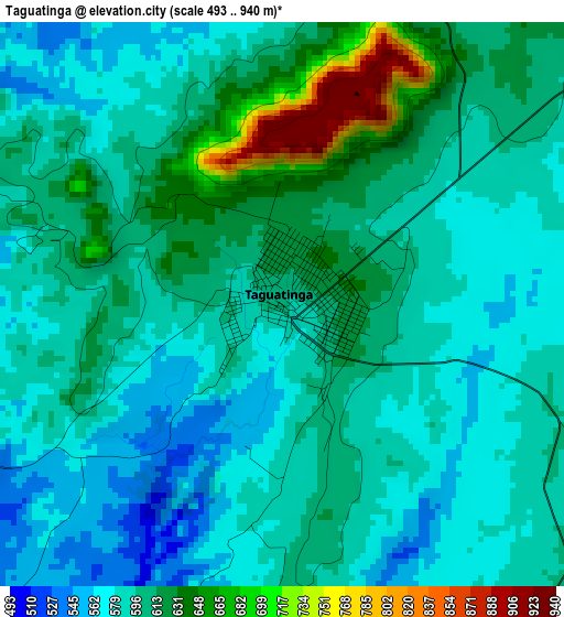
Below is the Elevation map of Taguatinga, which displays elevation range with different colors. Scale of the first map is from 493 to 940 m (1617 to 3084 ft) with average elevation of 600.5 meters (=1970 ft) [note 1]
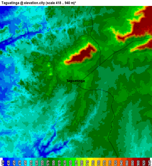
These maps also provides idea of topography and contour of this city, they are displayed at different zoom levels. More info about maps, scale and edge coordinates you can find below images.
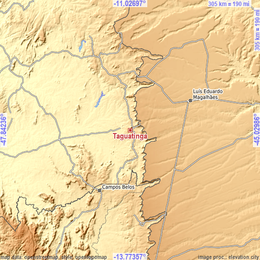
| \ | Map #1 | Map #2 | Topo.Map |
| Scale [m] | 493..940 m | 418..940 m | × |
| Scale [ft] | 1617..3084 ft | 1371..3084 ft | × |
| Average | 600.5 m = 1970 ft | 572.2 m = 1877 ft | × |
| Width | 9.54 km = 5.9 mi | 19.09 km = 11.9 mi | 305.4 km = 189.8 mi |
| Height | 9.54 km = 5.9 mi | 19.09 km = 11.9 mi | 305.4 km = 189.8 mi |
| ↑Max Latitude | -12.360967° | -12.318037° | -11.02697° |
| Latitude at center | -12.40389° | -12.40389° | -12.40389° |
| ↓Min Latitude | -12.446806° | -12.489715° | -13.77357° |
| ← Min Longitude | -46.480055° | -46.524001° | -47.84236° |
| Longitude center | -46.43611° | -46.43611° | -46.43611° |
| →Max Longitude | -46.392165° | -46.348219° | -45.02986° |
Nearby cities:
Cities around Taguatinga sort by population:
• Barreiras elevation 472 m
159.6 km,  79°
79°
• Minaçu 363 m
230.5 km,  236°
236°
• Posse 815 m
188 km,  177°
177°
• Campos Belos 629 m
79.2 km,  207°
207°
• Formosa do Rio Preto 495 m
202.6 km,  41°
41°
• Correntina 584 m
221.3 km,  118°
118°
• Riachão das Neves 503 m
181.3 km,  66°
66°
• Arraias 695 m
80.1 km,  222°
222°
• Iaciara 579 m
189.3 km,  186°
186°
• São Desidério 503 m
158.9 km,  88°
88°
• São Domingos 681 m
111.3 km,  173°
173°
• Cavalcante 810 m
190.4 km, 215°
Multilingual:
 En español:
Taguatinga elevación 599 m.
 En France:
Taguatinga élévation 599 m.
 Auf Deutsch:
Taguatinga höhe über dem Meeresspiegel ist 599 m.

Sources and notes:
- [note 1] Map square and city borders are not equal. Map elevation data is calculated only from area inside that square.
- [src 1] Elevation data from geonames database provided with same terms of usage.
- [src 2] The elevation map of Taguatinga is generated using elevation data from NASA's 3 arcsec (90m) resolution SRTM data.
- [src 3] Base (background) map © OpenStreetMap contributors tiles are generated by Geofabrik and OpenTopoMap.
Copyright & License:
This Taguatinga Elevation Map is licensed under CC BY-SA. You may reuse any part from this page, if you give a proper credit by linking to this URL:
 More info on terms of use page.