Rondonópolis elevation
Rondonópolis (Mato Grosso), Brazil elevation is 230 meters and Rondonópolis elevation in feet is 755 ft above sea level [src 1]. Rondonópolis is a populated place (feature code) with elevation that is 152 meters (499 ft) smaller than average city elevation in Brazil.
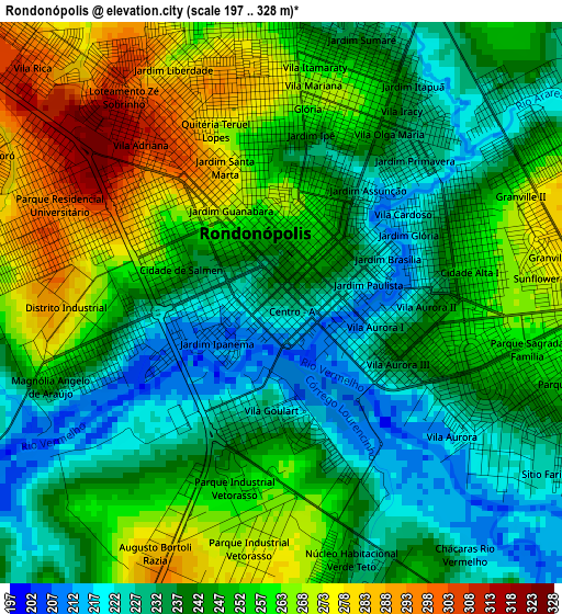
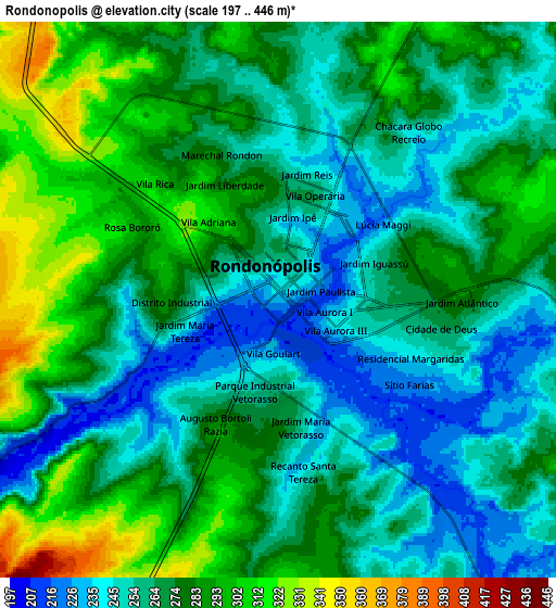
Below is the Elevation map of Rondonópolis, which displays elevation range with different colors. Scale of the first map is from 197 to 328 m (646 to 1076 ft) with average elevation of 247.9 meters (=813 ft) [note 1]
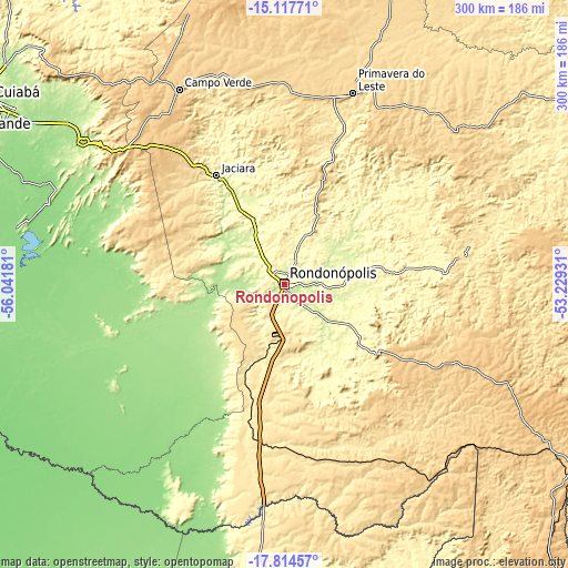
These maps also provides idea of topography and contour of this city, they are displayed at different zoom levels. More info about maps, scale and edge coordinates you can find below images.
| \ | Map #1 | Map #2 | Topo.Map |
| Scale [m] | 197..328 m | 197..446 m | × |
| Scale [ft] | 646..1076 ft | 646..1463 ft | × |
| Average | 247.9 m = 813 ft | 270.5 m = 887 ft | × |
| Width | 9.37 km = 5.8 mi | 18.74 km = 11.6 mi | 299.9 km = 186.3 mi |
| Height | 9.37 km = 5.8 mi | 18.74 km = 11.6 mi | 299.9 km = 186.3 mi |
| ↑Max Latitude | -16.428683° | -16.386528° | -15.11771° |
| Latitude at center | -16.47083° | -16.47083° | -16.47083° |
| ↓Min Latitude | -16.512967° | -16.555096° | -17.81457° |
| ← Min Longitude | -54.679505° | -54.723451° | -56.04181° |
| Longitude center | -54.63556° | -54.63556° | -54.63556° |
| →Max Longitude | -54.591615° | -54.547669° | -53.22931° |
Nearby cities:
Cities around Rondonópolis sort by population:
• Cuiabá elevation 193 m
184 km,  301°
301°
• Várzea Grande 197 m
184.3 km, 299°
• Coxim 205 m
226.7 km,  183°
183°
• Lucas 134 m
139.3 km,  276°
276°
• Jaciara 362 m
66.5 km,  327°
327°
• Poconé 150 m
213.3 km, 276°
• Chapada dos Guimarães 827 m
163.7 km,  313°
313°
• Poxoréo 364 m
75.2 km,  20°
20°
• Guiratinga 508 m
94.2 km,  81°
81°
• Alto Araguaia 672 m
177.9 km,  121°
121°
• Santo Antônio do Leverger 150 m
168 km,  293°
293°
• Barão de Melgaço 134 m
145.4 km, 282°
Multilingual:
 En español:
Rondonópolis elevación 230 m.
 En France:
Rondonópolis élévation 230 m.
 Auf Deutsch:
Rondonópolis höhe über dem Meeresspiegel ist 230 m.

Sources and notes:
- [note 1] Map square and city borders are not equal. Map elevation data is calculated only from area inside that square.
- [src 1] Elevation data from geonames database provided with same terms of usage.
- [src 2] The elevation map of Rondonópolis is generated using elevation data from NASA's 3 arcsec (90m) resolution SRTM data.
- [src 3] Base (background) map © OpenStreetMap contributors tiles are generated by Geofabrik and OpenTopoMap.
Copyright & License:
This Rondonópolis Elevation Map is licensed under CC BY-SA. You may reuse any part from this page, if you give a proper credit by linking to this URL:
 More info on terms of use page.