Chapada dos Guimarães elevation
Chapada dos Guimarães (Mato Grosso), Brazil elevation is 827 meters and Chapada dos Guimarães elevation in feet is 2713 ft above sea level [src 1]. Chapada dos Guimarães is a populated place (feature code) with elevation that is 445 meters (1460 ft) bigger than average city elevation in Brazil.
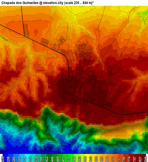
Below is the Elevation map of Chapada dos Guimarães, which displays elevation range with different colors. Scale of the first map is from 235 to 844 m (771 to 2769 ft) with average elevation of 661 meters (=2169 ft) [note 1]
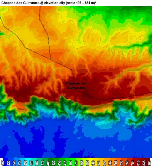
These maps also provides idea of topography and contour of this city, they are displayed at different zoom levels. More info about maps, scale and edge coordinates you can find below images.
| \ | Map #1 | Map #2 | Topo.Map |
| Scale [m] | 235..844 m | 197..861 m | × |
| Scale [ft] | 771..2769 ft | 646..2825 ft | × |
| Average | 661 m = 2169 ft | 533.8 m = 1751 ft | × |
| Width | 9.42 km = 5.9 mi | 18.84 km = 11.7 mi | 301.4 km = 187.3 mi |
| Height | 9.42 km = 5.9 mi | 18.84 km = 11.7 mi | 301.4 km = 187.3 mi |
| ↑Max Latitude | -15.418201° | -15.375832° | -14.10088° |
| Latitude at center | -15.46056° | -15.46056° | -15.46056° |
| ↓Min Latitude | -15.502911° | -15.545253° | -16.81137° |
| ← Min Longitude | -55.793665° | -55.837611° | -57.15597° |
| Longitude center | -55.74972° | -55.74972° | -55.74972° |
| →Max Longitude | -55.705775° | -55.661829° | -54.34347° |
Nearby cities:
Cities around Chapada dos Guimarães sort by population:
• Cuiabá elevation 193 m
40.1 km,  247°
247°
• Várzea Grande 197 m
45.9 km,  243°
243°
• Lucas 134 m
99 km,  191°
191°
• Jaciara 362 m
100.7 km,  123°
123°
• Poconé 150 m
128.7 km,  226°
226°
• Diamantino 282 m
138.8 km,  327°
327°
• Poxoréo 364 m
151.6 km,  106°
106°
• Nobres 200 m
103.1 km,  322°
322°
• Rosário Oeste 201 m
100.6 km,  313°
313°
• Nortelândia 230 m
159.1 km, 314°
• Santo Antônio do Leverger 150 m
57 km,  217°
217°
• Barão de Melgaço 134 m
84.9 km,  195°
195°
Multilingual:
 En español:
Chapada dos Guimarães elevación 827 m.
 En France:
Chapada dos Guimarães élévation 827 m.
 Auf Deutsch:
Chapada dos Guimarães höhe über dem Meeresspiegel ist 827 m.
 На русском:
Chapada dos Guimarães высота над уровнем моря 827 м
Sources and notes:
- [note 1] Map square and city borders are not equal. Map elevation data is calculated only from area inside that square.
- [src 1] Elevation data from geonames database provided with same terms of usage.
- [src 2] The elevation map of Chapada dos Guimarães is generated using elevation data from NASA's 3 arcsec (90m) resolution SRTM data.
- [src 3] Base (background) map © OpenStreetMap contributors tiles are generated by Geofabrik and OpenTopoMap.
Copyright & License:
This Chapada dos Guimarães Elevation Map is licensed under CC BY-SA. You may reuse any part from this page, if you give a proper credit by linking to this URL:
 More info on terms of use page.