Cuiabá elevation
Cuiabá (Mato Grosso), Brazil elevation is 193 meters and Cuiabá elevation in feet is 633 ft above sea level [src 1]. Cuiabá is a seat of a first-order administrative division (feature code) with elevation that is 189 meters (620 ft) smaller than average city elevation in Brazil.
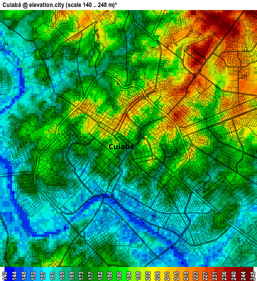
Below is the Elevation map of Cuiabá, which displays elevation range with different colors. Scale of the first map is from 140 to 248 m (459 to 814 ft) with average elevation of 180.8 meters (=593 ft) [note 1]
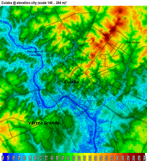
These maps also provides idea of topography and contour of this city, they are displayed at different zoom levels. More info about maps, scale and edge coordinates you can find below images.
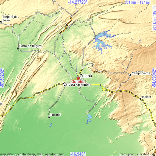
| \ | Map #1 | Map #2 | Topo.Map |
| Scale [m] | 140..248 m | 140..264 m | × |
| Scale [ft] | 459..814 ft | 459..866 ft | × |
| Average | 180.8 m = 593 ft | 186.1 m = 611 ft | × |
| Width | 9.41 km = 5.8 mi | 18.83 km = 11.7 mi | 301.2 km = 187.2 mi |
| Height | 9.41 km = 5.8 mi | 18.83 km = 11.7 mi | 301.2 km = 187.2 mi |
| ↑Max Latitude | -15.553778° | -15.511438° | -14.23729° |
| Latitude at center | -15.59611° | -15.59611° | -15.59611° |
| ↓Min Latitude | -15.638433° | -15.680747° | -16.946° |
| ← Min Longitude | -56.140615° | -56.184561° | -57.50292° |
| Longitude center | -56.09667° | -56.09667° | -56.09667° |
| →Max Longitude | -56.052725° | -56.008779° | -54.69042° |
Nearby cities:
Cities around Cuiabá sort by population:
• Várzea Grande elevation 197 m
6.8 km,  214°
214°
• Barra do Bugres 183 m
130 km,  296°
296°
• Lucas 134 m
83.8 km,  167°
167°
• Jaciara 362 m
127.5 km,  108°
108°
• Poconé 150 m
92.5 km,  217°
217°
• Diamantino 282 m
137.3 km,  344°
344°
• Chapada dos Guimarães 827 m
40.1 km,  67°
67°
• Nobres 200 m
100.5 km,  345°
345°
• Rosário Oeste 201 m
91.7 km, 337°
• Nortelândia 230 m
147.8 km,  329°
329°
• Santo Antônio do Leverger 150 m
30 km,  175°
175°
• Barão de Melgaço 134 m
67.9 km, 168°
Multilingual:
 En español:
Cuiabá elevación 193 m.
 En France:
Cuiabá élévation 193 m.


Sources and notes:
- [note 1] Map square and city borders are not equal. Map elevation data is calculated only from area inside that square.
- [src 1] Elevation data from geonames database provided with same terms of usage.
- [src 2] The elevation map of Cuiabá is generated using elevation data from NASA's 3 arcsec (90m) resolution SRTM data.
- [src 3] Base (background) map © OpenStreetMap contributors tiles are generated by Geofabrik and OpenTopoMap.
Copyright & License:
This Cuiabá Elevation Map is licensed under CC BY-SA. You may reuse any part from this page, if you give a proper credit by linking to this URL:
 More info on terms of use page.