Coxim elevation
Coxim (Mato Grosso do Sul), Brazil elevation is 205 meters and Coxim elevation in feet is 673 ft above sea level [src 1]. Coxim is a populated place (feature code) with elevation that is 177 meters (581 ft) smaller than average city elevation in Brazil.
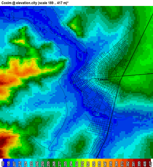
Below is the Elevation map of Coxim, which displays elevation range with different colors. Scale of the first map is from 189 to 417 m (620 to 1368 ft) with average elevation of 242.4 meters (=795 ft) [note 1]
These maps also provides idea of topography and contour of this city, they are displayed at different zoom levels. More info about maps, scale and edge coordinates you can find below images.
| \ | Map #1 | Map #2 | Topo.Map |
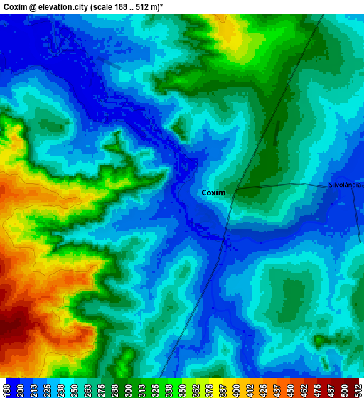
| Scale [m] | 189..417 m | 188..512 m | × |
| Scale [ft] | 620..1368 ft | 617..1680 ft | × |
| Average | 242.4 m = 795 ft | 271.4 m = 890 ft | × |
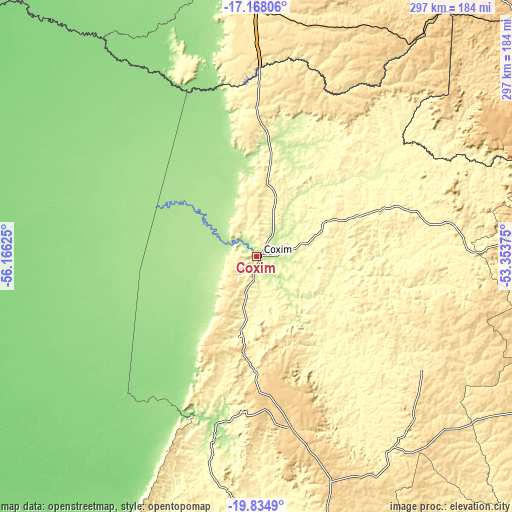
| Width | 9.27 km = 5.8 mi | 18.53 km = 11.5 mi | 296.5 km = 184.2 mi |
| Height | 9.27 km = 5.8 mi | 18.53 km = 11.5 mi | 296.5 km = 184.2 mi |
| ↑Max Latitude | -18.464992° | -18.423304° | -17.16806° |
| Latitude at center | -18.50667° | -18.50667° | -18.50667° |
| ↓Min Latitude | -18.548338° | -18.589995° | -19.8349° |
| ← Min Longitude | -54.803945° | -54.847891° | -56.16625° |
| Longitude center | -54.76° | -54.76° | -54.76° |
| →Max Longitude | -54.716055° | -54.672109° | -53.35375° |
Nearby cities:
Cities around Coxim sort by population:
• Campo Grande elevation 592 m
215.6 km,  176°
176°
• Rondonópolis 230 m
226.7 km,  3°
3°
• Aquidauana 157 m
243.5 km,  206°
206°
• Campo Verde 471 m
224.5 km,  161°
161°
• Anastácio 170 m
245.7 km, 206°
• Rio Verde de Mato Grosso 335 m
46.6 km,  190°
190°
• Ribas do Rio Pardo 382 m
239.5 km,  154°
154°
• Camapuã 410 m
136.6 km, 146°
• Alto Araguaia 672 m
210.4 km,  50°
50°
• Terenos 429 m
215.5 km, 182°
• Paraíso das Águas 594 m
192.6 km,  107°
107°
• Portelândia 857 m
254.8 km,  59°
59°
Multilingual:
 En español:
Coxim elevación 205 m.
 En France:
Coxim élévation 205 m.


Sources and notes:
- [note 1] Map square and city borders are not equal. Map elevation data is calculated only from area inside that square.
- [src 1] Elevation data from geonames database provided with same terms of usage.
- [src 2] The elevation map of Coxim is generated using elevation data from NASA's 3 arcsec (90m) resolution SRTM data.
- [src 3] Base (background) map © OpenStreetMap contributors tiles are generated by Geofabrik and OpenTopoMap.
Copyright & License:
This Coxim Elevation Map is licensed under CC BY-SA. You may reuse any part from this page, if you give a proper credit by linking to this URL:
 More info on terms of use page.