Guiratinga elevation
Guiratinga (Mato Grosso), Brazil elevation is 508 meters and Guiratinga elevation in feet is 1667 ft above sea level [src 1]. Guiratinga is a populated place (feature code) with elevation that is 126 meters (413 ft) bigger than average city elevation in Brazil.
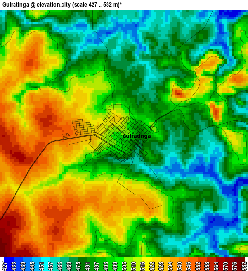
Below is the Elevation map of Guiratinga, which displays elevation range with different colors. Scale of the first map is from 427 to 582 m (1401 to 1909 ft) with average elevation of 498 meters (=1634 ft) [note 1]
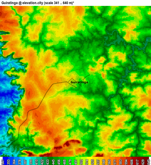
These maps also provides idea of topography and contour of this city, they are displayed at different zoom levels. More info about maps, scale and edge coordinates you can find below images.
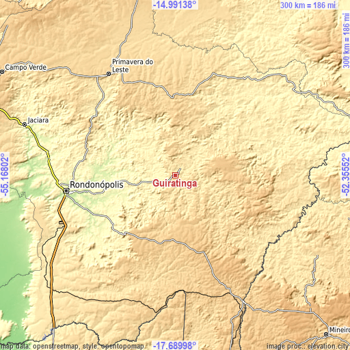
| \ | Map #1 | Map #2 | Topo.Map |
| Scale [m] | 427..582 m | 341..640 m | × |
| Scale [ft] | 1401..1909 ft | 1119..2100 ft | × |
| Average | 498 m = 1634 ft | 493.4 m = 1619 ft | × |
| Width | 9.38 km = 5.8 mi | 18.76 km = 11.7 mi | 300.1 km = 186.5 mi |
| Height | 9.38 km = 5.8 mi | 18.76 km = 11.7 mi | 300.1 km = 186.5 mi |
| ↑Max Latitude | -16.303166° | -16.260983° | -14.99138° |
| Latitude at center | -16.34534° | -16.34534° | -16.34534° |
| ↓Min Latitude | -16.387505° | -16.42966° | -17.68998° |
| ← Min Longitude | -53.805715° | -53.849661° | -55.16802° |
| Longitude center | -53.76177° | -53.76177° | -53.76177° |
| →Max Longitude | -53.717825° | -53.673879° | -52.35552° |
Nearby cities:
Cities around Guiratinga sort by population:
• Rondonópolis elevation 230 m
94.2 km,  261°
261°
• Barra do Garças 302 m
168.6 km,  72°
72°
• Mineiros 766 m
187.4 km,  136°
136°
• Lucas 134 m
231.7 km,  270°
270°
• Jaciara 362 m
135.6 km,  288°
288°
• Aragarças 306 m
168.9 km, 72°
• Poxoréo 364 m
87.7 km,  310°
310°
• Caiapônia 720 m
218.7 km,  108°
108°
• Piranhas 366 m
207.1 km,  92°
92°
• Alto Araguaia 672 m
122.5 km,  151°
151°
• Portelândia 857 m
160.8 km,  134°
134°
• Araguaiana 287 m
217.2 km, 71°
Multilingual:
 En español:
Guiratinga elevación 508 m.
 En France:
Guiratinga élévation 508 m.
 Auf Deutsch:
Guiratinga höhe über dem Meeresspiegel ist 508 m.

Sources and notes:
- [note 1] Map square and city borders are not equal. Map elevation data is calculated only from area inside that square.
- [src 1] Elevation data from geonames database provided with same terms of usage.
- [src 2] The elevation map of Guiratinga is generated using elevation data from NASA's 3 arcsec (90m) resolution SRTM data.
- [src 3] Base (background) map © OpenStreetMap contributors tiles are generated by Geofabrik and OpenTopoMap.
Copyright & License:
This Guiratinga Elevation Map is licensed under CC BY-SA. You may reuse any part from this page, if you give a proper credit by linking to this URL:
 More info on terms of use page.