Araguaiana elevation
Araguaiana (Mato Grosso), Brazil elevation is 287 meters and Araguaiana elevation in feet is 942 ft above sea level [src 1]. Araguaiana is a populated place (feature code) with elevation that is 95 meters (312 ft) smaller than average city elevation in Brazil.
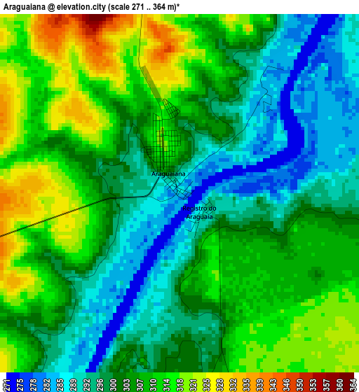
Below is the Elevation map of Araguaiana, which displays elevation range with different colors. Scale of the first map is from 271 to 364 m (889 to 1194 ft) with average elevation of 304.3 meters (=998 ft) [note 1]
These maps also provides idea of topography and contour of this city, they are displayed at different zoom levels. More info about maps, scale and edge coordinates you can find below images.
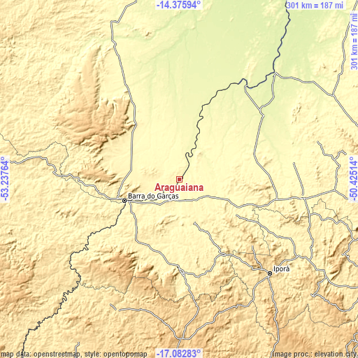
| \ | Map #1 | Topo.Map |
| Scale [m] | 271..364 m | × |
| Scale [ft] | 889..1194 ft | × |
| Average | 304.3 m = 998 ft | × |
| Width | 9.41 km = 5.8 mi | 301 km = 187 mi |
| Height | 9.41 km = 5.8 mi | 301 km = 187 mi |
| ↑Max Latitude | -15.691587° | -14.37594° |
| Latitude at center | -15.73389° | -15.73389° |
| ↓Min Latitude | -15.776184° | -17.08283° |
| ← Min Longitude | -51.875335° | -53.23764° |
| Longitude center | -51.83139° | -51.83139° |
| →Max Longitude | -51.787445° | -50.42514° |
Nearby cities:
Cities around Araguaiana sort by population:
• Barra do Garças elevation 302 m
48.7 km,  249°
249°
• Iporá 594 m
109.6 km,  135°
135°
• São Luís de Montes Belos 579 m
179 km,  119°
119°
• Nova Xavantina 271 m
131.5 km,  334°
334°
• Goiás 496 m
182.3 km,  97°
97°
• Aragarças 306 m
48.4 km, 247°
• Mozarlândia 300 m
174.3 km,  50°
50°
• Caiapônia 720 m
136 km,  179°
179°
• Piranhas 366 m
77.1 km, 179°
• Paraúna 679 m
200 km,  132°
132°
• Firminópolis 678 m
188.3 km, 120°
• Itapirapuã 351 m
130.7 km,  94°
94°
Multilingual:
 En español:
Araguaiana elevación 287 m.
 En France:
Araguaiana élévation 287 m.
 Auf Deutsch:
Araguaiana höhe über dem Meeresspiegel ist 287 m.

Sources and notes:
- [note 1] Map square and city borders are not equal. Map elevation data is calculated only from area inside that square.
- [src 1] Elevation data from geonames database provided with same terms of usage.
- [src 2] The elevation map of Araguaiana is generated using elevation data from NASA's 3 arcsec (90m) resolution SRTM data.
- [src 3] Base (background) map © OpenStreetMap contributors tiles are generated by Geofabrik and OpenTopoMap.
Copyright & License:
This Araguaiana Elevation Map is licensed under CC BY-SA. You may reuse any part from this page, if you give a proper credit by linking to this URL:
 More info on terms of use page.