Uberlândia elevation
Uberlândia (Minas Gerais), Brazil elevation is 867 meters and Uberlândia elevation in feet is 2844 ft above sea level [src 1]. Uberlândia is a populated place (feature code) with elevation that is 485 meters (1591 ft) bigger than average city elevation in Brazil.
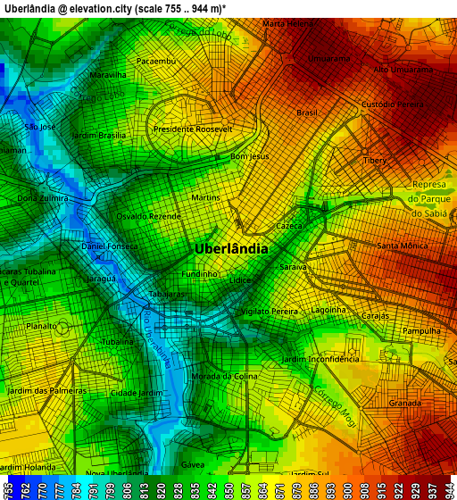
Below is the Elevation map of Uberlândia, which displays elevation range with different colors. Scale of the first map is from 755 to 944 m (2477 to 3097 ft) with average elevation of 857.1 meters (=2812 ft) [note 1]
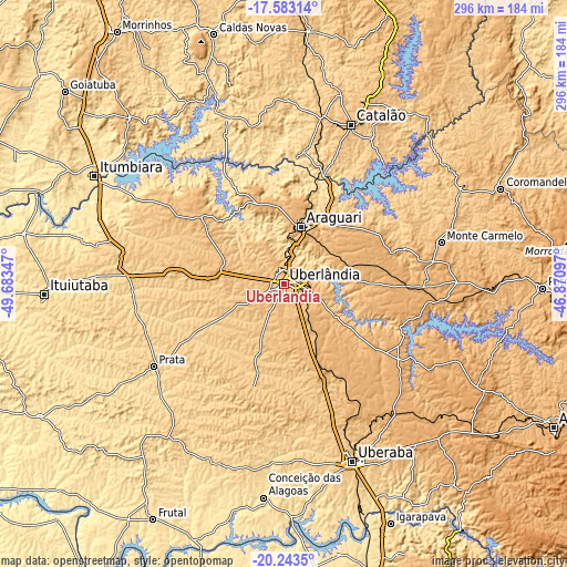
These maps also provides idea of topography and contour of this city, they are displayed at different zoom levels. More info about maps, scale and edge coordinates you can find below images.

| \ | Map #1 | Map #2 | Topo.Map |
| Scale [m] | 755..944 m | 708..952 m | × |
| Scale [ft] | 2477..3097 ft | 2323..3123 ft | × |
| Average | 857.1 m = 2812 ft | 862.8 m = 2831 ft | × |
| Width | 9.24 km = 5.7 mi | 18.49 km = 11.5 mi | 295.8 km = 183.8 mi |
| Height | 9.24 km = 5.7 mi | 18.49 km = 11.5 mi | 295.8 km = 183.8 mi |
| ↑Max Latitude | -18.877033° | -18.835447° | -17.58314° |
| Latitude at center | -18.91861° | -18.91861° | -18.91861° |
| ↓Min Latitude | -18.960176° | -19.001732° | -20.2435° |
| ← Min Longitude | -48.321165° | -48.365111° | -49.68347° |
| Longitude center | -48.27722° | -48.27722° | -48.27722° |
| →Max Longitude | -48.233275° | -48.189329° | -46.87097° |
Nearby cities:
Cities around Uberlândia sort by population:
• Uberaba elevation 772 m
99.1 km,  158°
158°
• Araguari 925 m
31.6 km,  17°
17°
• Itumbiara 450 m
113.3 km,  299°
299°
• Catalão 843 m
90.7 km, 22°
• Monte Carmelo 871 m
84.7 km,  75°
75°
• Tupaciguara 871 m
57.8 km,  308°
308°
• Coromandel 941 m
123.8 km,  66°
66°
• Prata 642 m
80.5 km,  237°
237°
• Conceição das Alagoas 513 m
111.4 km,  186°
186°
• Monte Alegre de Minas 733 m
63.7 km,  274°
274°
• Centralina 518 m
104 km,  290°
290°
• Buriti Alegre 802 m
118.2 km,  317°
317°
Multilingual:
 En español:
Uberlândia elevación 867 m.
 En France:
Uberlândia élévation 867 m.
 Auf Deutsch:
Uberlândia höhe über dem Meeresspiegel ist 867 m.

Sources and notes:
- [note 1] Map square and city borders are not equal. Map elevation data is calculated only from area inside that square.
- [src 1] Elevation data from geonames database provided with same terms of usage.
- [src 2] The elevation map of Uberlândia is generated using elevation data from NASA's 3 arcsec (90m) resolution SRTM data.
- [src 3] Base (background) map © OpenStreetMap contributors tiles are generated by Geofabrik and OpenTopoMap.
Copyright & License:
This Uberlândia Elevation Map is licensed under CC BY-SA. You may reuse any part from this page, if you give a proper credit by linking to this URL:
 More info on terms of use page.