Itumbiara elevation
Itumbiara (Goiás), Brazil elevation is 450 meters and Itumbiara elevation in feet is 1476 ft above sea level [src 1]. Itumbiara is a populated place (feature code) with elevation that is 68 meters (223 ft) bigger than average city elevation in Brazil.
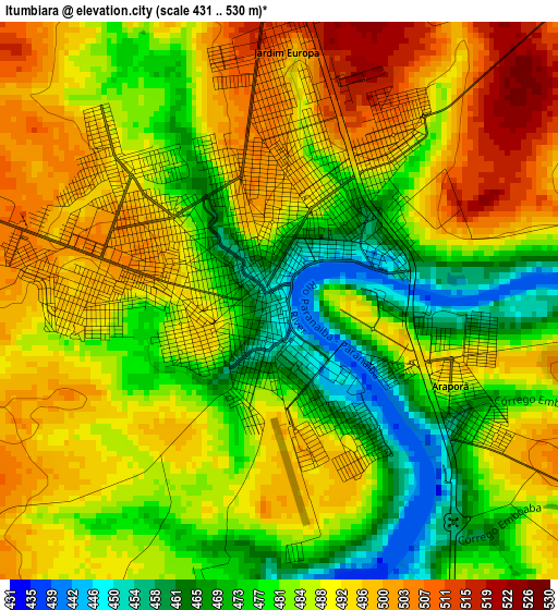
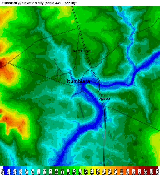
Below is the Elevation map of Itumbiara, which displays elevation range with different colors. Scale of the first map is from 431 to 530 m (1414 to 1739 ft) with average elevation of 485.8 meters (=1594 ft) [note 1]
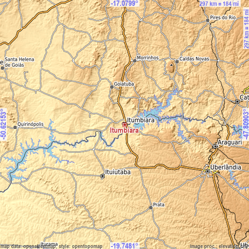
These maps also provides idea of topography and contour of this city, they are displayed at different zoom levels. More info about maps, scale and edge coordinates you can find below images.
| \ | Map #1 | Map #2 | Topo.Map |
| Scale [m] | 431..530 m | 431..665 m | × |
| Scale [ft] | 1414..1739 ft | 1414..2182 ft | × |
| Average | 485.8 m = 1594 ft | 504.8 m = 1656 ft | × |
| Width | 9.27 km = 5.8 mi | 18.54 km = 11.5 mi | 296.7 km = 184.4 mi |
| Height | 9.27 km = 5.8 mi | 18.54 km = 11.5 mi | 296.7 km = 184.4 mi |
| ↑Max Latitude | -18.377471° | -18.335762° | -17.0799° |
| Latitude at center | -18.41917° | -18.41917° | -18.41917° |
| ↓Min Latitude | -18.460859° | -18.502538° | -19.7481° |
| ← Min Longitude | -49.259225° | -49.303171° | -50.62153° |
| Longitude center | -49.21528° | -49.21528° | -49.21528° |
| →Max Longitude | -49.171335° | -49.127389° | -47.80903° |
Nearby cities:
Cities around Itumbiara sort by population:
• Ituiutaba elevation 571 m
67 km,  202°
202°
• Caldas Novas 695 m
97.4 km,  39°
39°
• Morrinhos 751 m
77.5 km,  9°
9°
• Goiatuba 768 m
47.6 km,  341°
341°
• Tupaciguara 871 m
57.1 km,  109°
109°
• Prata 642 m
103.4 km,  162°
162°
• Pontalina 627 m
102.4 km,  346°
346°
• Capinópolis 536 m
47.4 km,  231°
231°
• Monte Alegre de Minas 733 m
61.3 km,  144°
144°
• Santa Vitória 474 m
106.3 km,  243°
243°
• Centralina 518 m
18.4 km,  174°
174°
• Buriti Alegre 802 m
36.1 km,  30°
30°
Multilingual:
 En español:
Itumbiara elevación 450 m.
 En France:
Itumbiara élévation 450 m.
 Auf Deutsch:
Itumbiara höhe über dem Meeresspiegel ist 450 m.

Sources and notes:
- [note 1] Map square and city borders are not equal. Map elevation data is calculated only from area inside that square.
- [src 1] Elevation data from geonames database provided with same terms of usage.
- [src 2] The elevation map of Itumbiara is generated using elevation data from NASA's 3 arcsec (90m) resolution SRTM data.
- [src 3] Base (background) map © OpenStreetMap contributors tiles are generated by Geofabrik and OpenTopoMap.
Copyright & License:
This Itumbiara Elevation Map is licensed under CC BY-SA. You may reuse any part from this page, if you give a proper credit by linking to this URL:
 More info on terms of use page.