Prata elevation
Prata (Minas Gerais), Brazil elevation is 642 meters and Prata elevation in feet is 2106 ft above sea level [src 1]. Prata is a populated place (feature code) with elevation that is 260 meters (853 ft) bigger than average city elevation in Brazil.
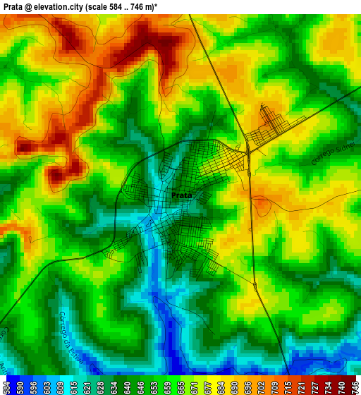
Below is the Elevation map of Prata, which displays elevation range with different colors. Scale of the first map is from 584 to 746 m (1916 to 2448 ft) with average elevation of 659.5 meters (=2164 ft) [note 1]
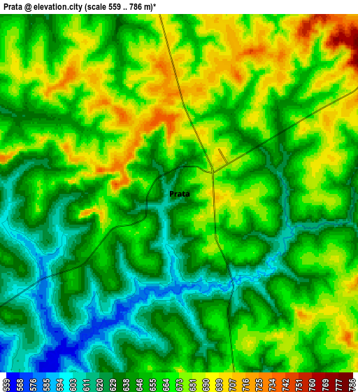
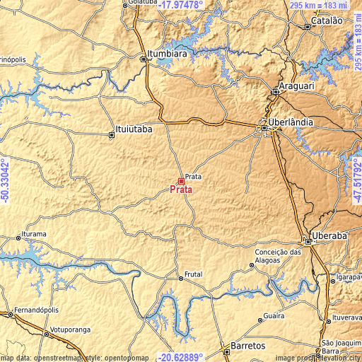
These maps also provides idea of topography and contour of this city, they are displayed at different zoom levels. More info about maps, scale and edge coordinates you can find below images.
| \ | Map #1 | Map #2 | Topo.Map |
| Scale [m] | 584..746 m | 559..786 m | × |
| Scale [ft] | 1916..2448 ft | 1834..2579 ft | × |
| Average | 659.5 m = 2164 ft | 656.2 m = 2153 ft | × |
| Width | 9.22 km = 5.7 mi | 18.45 km = 11.5 mi | 295.1 km = 183.4 mi |
| Height | 9.22 km = 5.7 mi | 18.45 km = 11.5 mi | 295.1 km = 183.4 mi |
| ↑Max Latitude | -19.265741° | -19.224251° | -17.97478° |
| Latitude at center | -19.30722° | -19.30722° | -19.30722° |
| ↓Min Latitude | -19.348689° | -19.390147° | -20.62889° |
| ← Min Longitude | -48.968115° | -49.012061° | -50.33042° |
| Longitude center | -48.92417° | -48.92417° | -48.92417° |
| →Max Longitude | -48.880225° | -48.836279° | -47.51792° |
Nearby cities:
Cities around Prata sort by population:
• Uberlândia elevation 867 m
80.5 km,  57°
57°
• Araguari 925 m
106.7 km,  46°
46°
• Ituiutaba 571 m
67.6 km,  303°
303°
• Itumbiara 450 m
103.4 km,  342°
342°
• Frutal 511 m
79.8 km,  181°
181°
• Tupaciguara 871 m
82.8 km,  16°
16°
• Conceição das Alagoas 513 m
87.8 km,  140°
140°
• Campina Verde 549 m
64.5 km,  246°
246°
• Capinópolis 536 m
97.2 km,  315°
315°
• Monte Alegre de Minas 733 m
48.8 km,  5°
5°
• Riolândia 443 m
109.1 km,  226°
226°
• Centralina 518 m
85.5 km, 340°
Multilingual:
 En español:
Prata elevación 642 m.
 En France:
Prata élévation 642 m.


Sources and notes:
- [note 1] Map square and city borders are not equal. Map elevation data is calculated only from area inside that square.
- [src 1] Elevation data from geonames database provided with same terms of usage.
- [src 2] The elevation map of Prata is generated using elevation data from NASA's 3 arcsec (90m) resolution SRTM data.
- [src 3] Base (background) map © OpenStreetMap contributors tiles are generated by Geofabrik and OpenTopoMap.
Copyright & License:
This Prata Elevation Map is licensed under CC BY-SA. You may reuse any part from this page, if you give a proper credit by linking to this URL:
 More info on terms of use page.