Monte Carmelo elevation
Monte Carmelo (Minas Gerais), Brazil elevation is 871 meters and Monte Carmelo elevation in feet is 2858 ft above sea level [src 1]. Monte Carmelo is a populated place (feature code) with elevation that is 489 meters (1604 ft) bigger than average city elevation in Brazil.
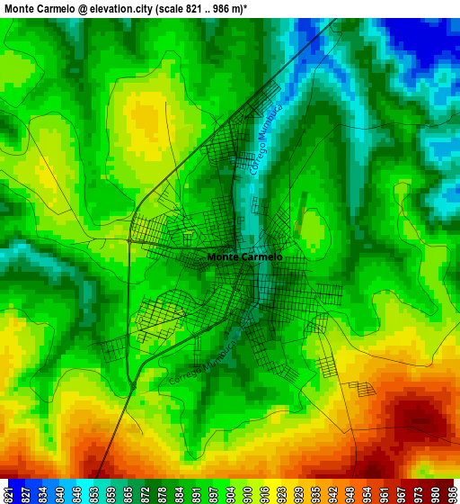
Below is the Elevation map of Monte Carmelo, which displays elevation range with different colors. Scale of the first map is from 821 to 986 m (2694 to 3235 ft) with average elevation of 896.4 meters (=2941 ft) [note 1]
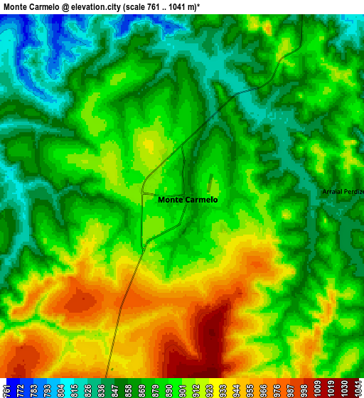
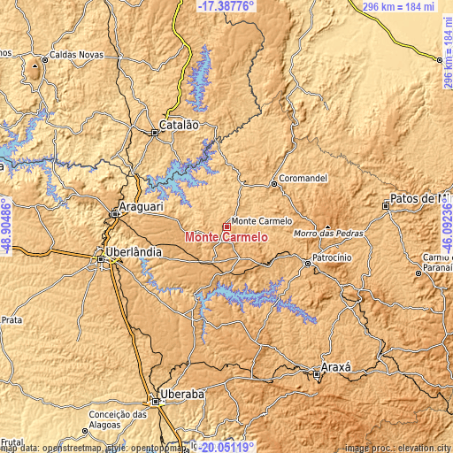
These maps also provides idea of topography and contour of this city, they are displayed at different zoom levels. More info about maps, scale and edge coordinates you can find below images.
| \ | Map #1 | Map #2 | Topo.Map |
| Scale [m] | 821..986 m | 761..1041 m | × |
| Scale [ft] | 2694..3235 ft | 2497..3415 ft | × |
| Average | 896.4 m = 2941 ft | 888.4 m = 2915 ft | × |
| Width | 9.26 km = 5.8 mi | 18.51 km = 11.5 mi | 296.1 km = 184 mi |
| Height | 9.26 km = 5.8 mi | 18.51 km = 11.5 mi | 296.2 km = 184 mi |
| ↑Max Latitude | -18.683096° | -18.641461° | -17.38776° |
| Latitude at center | -18.72472° | -18.72472° | -18.72472° |
| ↓Min Latitude | -18.766334° | -18.807938° | -20.05119° |
| ← Min Longitude | -47.542555° | -47.586501° | -48.90486° |
| Longitude center | -47.49861° | -47.49861° | -47.49861° |
| →Max Longitude | -47.454665° | -47.410719° | -46.09236° |
Nearby cities:
Cities around Monte Carmelo sort by population:
• Uberlândia elevation 867 m
84.7 km,  255°
255°
• Uberaba 772 m
122.6 km,  201°
201°
• Patos de Minas 842 m
104.6 km,  81°
81°
• Araguari 925 m
73 km,  276°
276°
• Araxá 1002 m
113 km,  148°
148°
• Patrocínio 965 m
58.6 km,  114°
114°
• Catalão 843 m
78.1 km,  322°
322°
• Coromandel 941 m
42.1 km,  48°
48°
• Sacramento 841 m
127 km,  177°
177°
• Vazante 665 m
103 km,  37°
37°
• Presidente Olegário 960 m
118.9 km,  73°
73°
• Lagoa Formosa 878 m
115 km,  92°
92°
Multilingual:
 En español:
Monte Carmelo elevación 871 m.
 En France:
Monte Carmelo élévation 871 m.
 Auf Deutsch:
Monte Carmelo höhe über dem Meeresspiegel ist 871 m.

Sources and notes:
- [note 1] Map square and city borders are not equal. Map elevation data is calculated only from area inside that square.
- [src 1] Elevation data from geonames database provided with same terms of usage.
- [src 2] The elevation map of Monte Carmelo is generated using elevation data from NASA's 3 arcsec (90m) resolution SRTM data.
- [src 3] Base (background) map © OpenStreetMap contributors tiles are generated by Geofabrik and OpenTopoMap.
Copyright & License:
This Monte Carmelo Elevation Map is licensed under CC BY-SA. You may reuse any part from this page, if you give a proper credit by linking to this URL:
 More info on terms of use page.