Uberaba elevation
Uberaba (Minas Gerais), Brazil elevation is 772 meters and Uberaba elevation in feet is 2533 ft above sea level [src 1]. Uberaba is a populated place (feature code) with elevation that is 390 meters (1280 ft) bigger than average city elevation in Brazil.
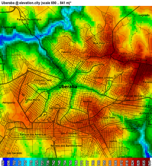
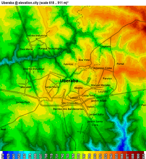
Below is the Elevation map of Uberaba, which displays elevation range with different colors. Scale of the first map is from 690 to 841 m (2264 to 2759 ft) with average elevation of 782.5 meters (=2567 ft) [note 1]
These maps also provides idea of topography and contour of this city, they are displayed at different zoom levels. More info about maps, scale and edge coordinates you can find below images.
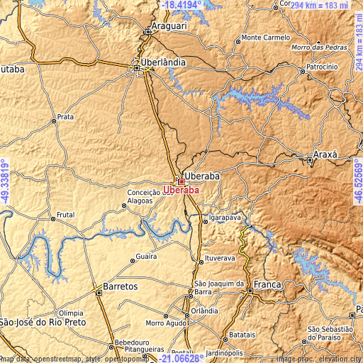
| \ | Map #1 | Map #2 | Topo.Map |
| Scale [m] | 690..841 m | 618..911 m | × |
| Scale [ft] | 2264..2759 ft | 2028..2989 ft | × |
| Average | 782.5 m = 2567 ft | 769.5 m = 2525 ft | × |
| Width | 9.2 km = 5.7 mi | 18.4 km = 11.4 mi | 294.3 km = 182.9 mi |
| Height | 9.2 km = 5.7 mi | 18.4 km = 11.4 mi | 294.3 km = 182.9 mi |
| ↑Max Latitude | -19.706964° | -19.665587° | -18.4194° |
| Latitude at center | -19.74833° | -19.74833° | -19.74833° |
| ↓Min Latitude | -19.789685° | -19.83103° | -21.06628° |
| ← Min Longitude | -47.975885° | -48.019831° | -49.33819° |
| Longitude center | -47.93194° | -47.93194° | -47.93194° |
| →Max Longitude | -47.887995° | -47.844049° | -46.52569° |
Nearby cities:
Cities around Uberaba sort by population:
• Uberlândia elevation 867 m
99.1 km,  338°
338°
• Franca 1002 m
103.9 km,  147°
147°
• São Joaquim da Barra 623 m
93 km,  175°
175°
• Ituverava 607 m
67.6 km,  166°
166°
• Guaíra 516 m
74.7 km,  211°
211°
• Igarapava 572 m
37.6 km, 149°
• Guará 575 m
76.4 km, 171°
• Miguelópolis 515 m
49.1 km,  192°
192°
• Sacramento 841 m
53.1 km,  104°
104°
• Conceição das Alagoas 513 m
51.2 km,  248°
248°
• Ipuã 551 m
77.1 km, 186°
• Pedregulho 1044 m
73.9 km,  139°
139°
Multilingual:
 En español:
Uberaba elevación 772 m.
 En France:
Uberaba élévation 772 m.


Sources and notes:
- [note 1] Map square and city borders are not equal. Map elevation data is calculated only from area inside that square.
- [src 1] Elevation data from geonames database provided with same terms of usage.
- [src 2] The elevation map of Uberaba is generated using elevation data from NASA's 3 arcsec (90m) resolution SRTM data.
- [src 3] Base (background) map © OpenStreetMap contributors tiles are generated by Geofabrik and OpenTopoMap.
Copyright & License:
This Uberaba Elevation Map is licensed under CC BY-SA. You may reuse any part from this page, if you give a proper credit by linking to this URL:
 More info on terms of use page.