Jatobá elevation
Jatobá (Pernambuco), Brazil elevation is 286 meters and Jatobá elevation in feet is 938 ft above sea level [src 1]. Jatobá is a populated place (feature code) with elevation that is 96 meters (315 ft) smaller than average city elevation in Brazil.
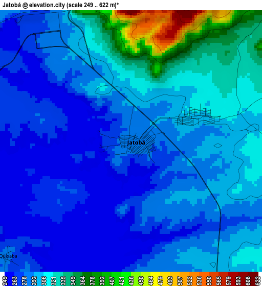
Below is the Elevation map of Jatobá, which displays elevation range with different colors. Scale of the first map is from 249 to 622 m (817 to 2041 ft) with average elevation of 297.3 meters (=975 ft) [note 1]
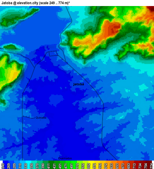
These maps also provides idea of topography and contour of this city, they are displayed at different zoom levels. More info about maps, scale and edge coordinates you can find below images.
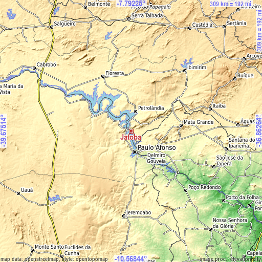
| \ | Map #1 | Map #2 | Topo.Map |
| Scale [m] | 249..622 m | 249..774 m | × |
| Scale [ft] | 817..2041 ft | 817..2539 ft | × |
| Average | 297.3 m = 975 ft | 332.3 m = 1090 ft | × |
| Width | 9.65 km = 6 mi | 19.29 km = 12 mi | 308.7 km = 191.8 mi |
| Height | 9.65 km = 6 mi | 19.29 km = 12 mi | 308.7 km = 191.8 mi |
| ↑Max Latitude | -9.139675° | -9.096285° | -7.79225° |
| Latitude at center | -9.18306° | -9.18306° | -9.18306° |
| ↓Min Latitude | -9.226439° | -9.269814° | -10.56844° |
| ← Min Longitude | -38.312835° | -38.356781° | -39.67514° |
| Longitude center | -38.26889° | -38.26889° | -38.26889° |
| →Max Longitude | -38.224945° | -38.180999° | -36.86264° |
Nearby cities:
Cities around Jatobá sort by population:
• Paulo Afonso elevation 245 m
25.5 km,  166°
166°
• Delmiro Gouveia 246 m
37.4 km,  127°
127°
• Floresta 321 m
72.6 km,  333°
333°
• Jeremoabo 334 m
101.9 km,  193°
193°
• Itaíba 481 m
96.5 km,  74°
74°
• Ibimirim 409 m
95.6 km,  41°
41°
• Belém de São Francisco 317 m
90.2 km,  301°
301°
• Canindé de São Francisco 179 m
74.7 km,  135°
135°
• Inhapi 407 m
57.3 km,  94°
94°
• Carnaíba 379 m
85.2 km,  50°
50°
• Água Branca 569 m
37.5 km,  103°
103°
• Mata Grande 624 m
59.4 km,  82°
82°
Multilingual:
 En español:
Jatobá elevación 286 m.
 En France:
Jatobá élévation 286 m.


Sources and notes:
- [note 1] Map square and city borders are not equal. Map elevation data is calculated only from area inside that square.
- [src 1] Elevation data from geonames database provided with same terms of usage.
- [src 2] The elevation map of Jatobá is generated using elevation data from NASA's 3 arcsec (90m) resolution SRTM data.
- [src 3] Base (background) map © OpenStreetMap contributors tiles are generated by Geofabrik and OpenTopoMap.
Copyright & License:
This Jatobá Elevation Map is licensed under CC BY-SA. You may reuse any part from this page, if you give a proper credit by linking to this URL:
 More info on terms of use page.