Floresta elevation
Floresta (Pernambuco), Brazil elevation is 321 meters and Floresta elevation in feet is 1053 ft above sea level [src 1]. Floresta is a populated place (feature code) with elevation that is 61 meters (200 ft) smaller than average city elevation in Brazil.
Below is the Elevation map of Floresta, which displays elevation range with different colors. Scale of the first map is from 308 to 387 m (1010 to 1270 ft) with average elevation of 330.7 meters (=1085 ft) [note 1]
These maps also provides idea of topography and contour of this city, they are displayed at different zoom levels. More info about maps, scale and edge coordinates you can find below images.
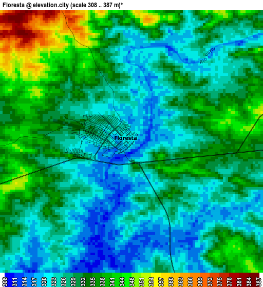
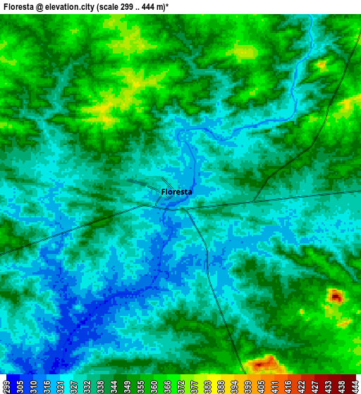
| \ | Map #1 | Map #2 | Topo.Map |
| Scale [m] | 308..387 m | 299..444 m | × |
| Scale [ft] | 1010..1270 ft | 981..1457 ft | × |
| Average | 330.7 m = 1085 ft | 339.7 m = 1115 ft | × |
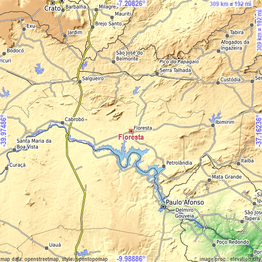
| Width | 9.66 km = 6 mi | 19.33 km = 12 mi | 309.2 km = 192.1 mi |
| Height | 9.66 km = 6 mi | 19.33 km = 12 mi | 309.2 km = 192.1 mi |
| ↑Max Latitude | -8.557656° | -8.514198° | -7.20826° |
| Latitude at center | -8.60111° | -8.60111° | -8.60111° |
| ↓Min Latitude | -8.644559° | -8.688002° | -9.98886° |
| ← Min Longitude | -38.612555° | -38.656501° | -39.97486° |
| Longitude center | -38.56861° | -38.56861° | -38.56861° |
| →Max Longitude | -38.524665° | -38.480719° | -37.16236° |
Nearby cities:
Cities around Floresta sort by population:
• Paulo Afonso elevation 245 m
97.6 km,  156°
156°
• Serra Talhada 436 m
74 km,  23°
23°
• Salgueiro 420 m
84.3 km,  314°
314°
• Delmiro Gouveia 246 m
107.6 km,  144°
144°
• Jatobá 286 m
72.6 km,  153°
153°
• Cabrobó 327 m
82.1 km,  276°
276°
• São José do Belmonte 493 m
84.9 km,  345°
345°
• Ibimirim 409 m
96.8 km,  86°
86°
• Flores 467 m
104.5 km,  38°
38°
• Belém de São Francisco 317 m
46.8 km,  248°
248°
• Carnaíba 379 m
99.8 km,  96°
96°
• Água Branca 569 m
101 km, 136°
Multilingual:
 En español:
Floresta elevación 321 m.
 En France:
Floresta élévation 321 m.
 Auf Deutsch:
Floresta höhe über dem Meeresspiegel ist 321 m.

Sources and notes:
- [note 1] Map square and city borders are not equal. Map elevation data is calculated only from area inside that square.
- [src 1] Elevation data from geonames database provided with same terms of usage.
- [src 2] The elevation map of Floresta is generated using elevation data from NASA's 3 arcsec (90m) resolution SRTM data.
- [src 3] Base (background) map © OpenStreetMap contributors tiles are generated by Geofabrik and OpenTopoMap.
Copyright & License:
This Floresta Elevation Map is licensed under CC BY-SA. You may reuse any part from this page, if you give a proper credit by linking to this URL:
 More info on terms of use page.