Ibimirim elevation
Ibimirim (Pernambuco), Brazil elevation is 409 meters and Ibimirim elevation in feet is 1342 ft above sea level [src 1]. Ibimirim is a populated place (feature code) with elevation that is 27 meters (89 ft) bigger than average city elevation in Brazil.
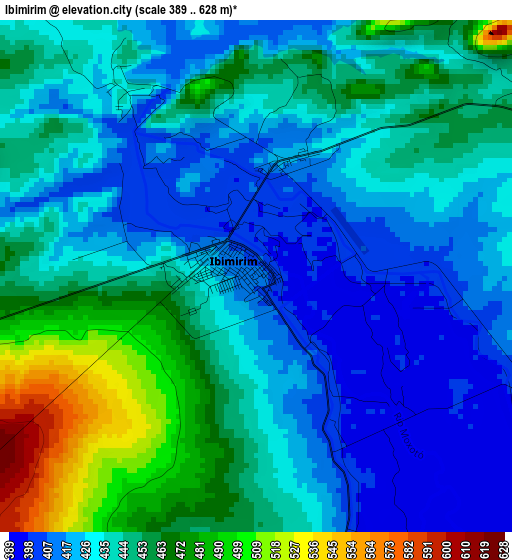
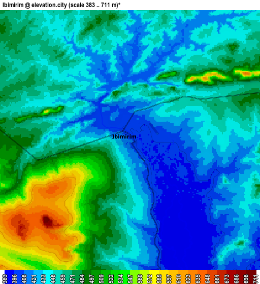
Below is the Elevation map of Ibimirim, which displays elevation range with different colors. Scale of the first map is from 389 to 628 m (1276 to 2060 ft) with average elevation of 440.6 meters (=1446 ft) [note 1]
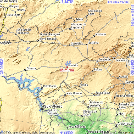
These maps also provides idea of topography and contour of this city, they are displayed at different zoom levels. More info about maps, scale and edge coordinates you can find below images.
| \ | Map #1 | Map #2 | Topo.Map |
| Scale [m] | 389..628 m | 383..711 m | × |
| Scale [ft] | 1276..2060 ft | 1257..2333 ft | × |
| Average | 440.6 m = 1446 ft | 460.5 m = 1511 ft | × |
| Width | 9.66 km = 6 mi | 19.33 km = 12 mi | 309.2 km = 192.1 mi |
| Height | 9.66 km = 6 mi | 19.33 km = 12 mi | 309.3 km = 192.2 mi |
| ↑Max Latitude | -8.4971° | -8.453634° | -7.1475° |
| Latitude at center | -8.54056° | -8.54056° | -8.54056° |
| ↓Min Latitude | -8.584016° | -8.627466° | -9.92855° |
| ← Min Longitude | -37.734225° | -37.778171° | -39.09653° |
| Longitude center | -37.69028° | -37.69028° | -37.69028° |
| →Max Longitude | -37.646335° | -37.602389° | -36.28403° |
Nearby cities:
Cities around Ibimirim sort by population:
• Arcoverde elevation 670 m
71.3 km,  79°
79°
• Buíque 804 m
59.5 km,  98°
98°
• Sertânia 558 m
69.9 km,  42°
42°
• Custódia 540 m
50.6 km,  5°
5°
• Itaíba 481 m
54 km,  146°
146°
• Flores 467 m
81.1 km,  337°
337°
• Pedra 614 m
82.6 km,  86°
86°
• Inhapi 407 m
76 km,  184°
184°
• Carnaíba 379 m
17.9 km,  171°
171°
• Tupanatinga 718 m
45.2 km,  121°
121°
• Água Branca 569 m
84.5 km,  198°
198°
• Mata Grande 624 m
64.3 km, 184°
Multilingual:
 En español:
Ibimirim elevación 409 m.
 En France:
Ibimirim élévation 409 m.
 Auf Deutsch:
Ibimirim höhe über dem Meeresspiegel ist 409 m.

Sources and notes:
- [note 1] Map square and city borders are not equal. Map elevation data is calculated only from area inside that square.
- [src 1] Elevation data from geonames database provided with same terms of usage.
- [src 2] The elevation map of Ibimirim is generated using elevation data from NASA's 3 arcsec (90m) resolution SRTM data.
- [src 3] Base (background) map © OpenStreetMap contributors tiles are generated by Geofabrik and OpenTopoMap.
Copyright & License:
This Ibimirim Elevation Map is licensed under CC BY-SA. You may reuse any part from this page, if you give a proper credit by linking to this URL:
 More info on terms of use page.