Inhapi elevation
Inhapi (Alagoas), Brazil elevation is 407 meters and Inhapi elevation in feet is 1335 ft above sea level [src 1]. Inhapi is a populated place (feature code) with elevation that is 25 meters (82 ft) bigger than average city elevation in Brazil.
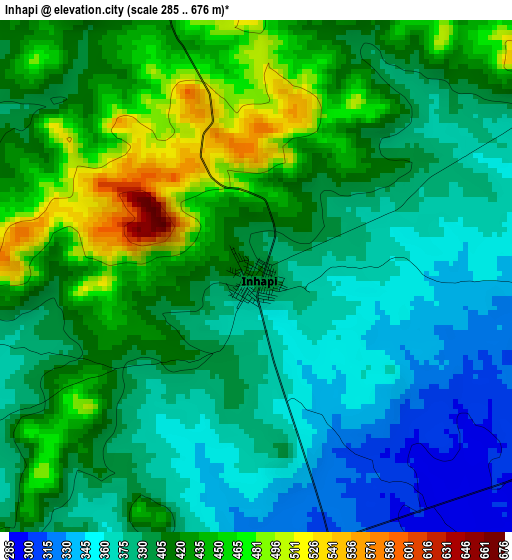
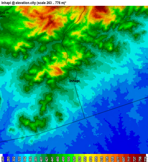
Below is the Elevation map of Inhapi, which displays elevation range with different colors. Scale of the first map is from 285 to 676 m (935 to 2218 ft) with average elevation of 405.4 meters (=1330 ft) [note 1]
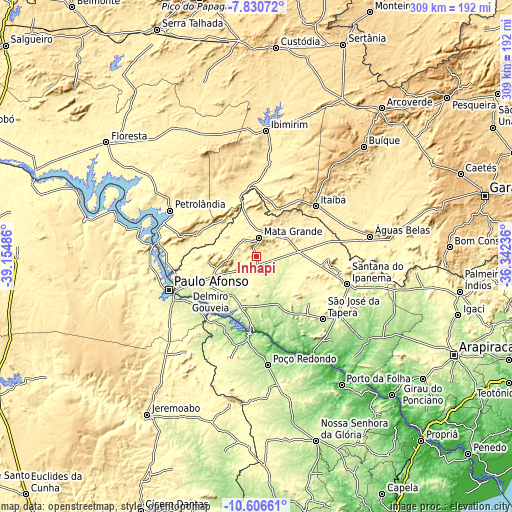
These maps also provides idea of topography and contour of this city, they are displayed at different zoom levels. More info about maps, scale and edge coordinates you can find below images.
| \ | Map #1 | Map #2 | Topo.Map |
| Scale [m] | 285..676 m | 263..776 m | × |
| Scale [ft] | 935..2218 ft | 863..2546 ft | × |
| Average | 405.4 m = 1330 ft | 396.6 m = 1301 ft | × |
| Width | 9.65 km = 6 mi | 19.29 km = 12 mi | 308.7 km = 191.8 mi |
| Height | 9.65 km = 6 mi | 19.29 km = 12 mi | 308.7 km = 191.8 mi |
| ↑Max Latitude | -9.17801° | -9.134625° | -7.83072° |
| Latitude at center | -9.22139° | -9.22139° | -9.22139° |
| ↓Min Latitude | -9.264765° | -9.308134° | -10.60661° |
| ← Min Longitude | -37.792555° | -37.836501° | -39.15486° |
| Longitude center | -37.74861° | -37.74861° | -37.74861° |
| →Max Longitude | -37.704665° | -37.660719° | -36.34236° |
Nearby cities:
Cities around Inhapi sort by population:
• Paulo Afonso elevation 245 m
55.1 km,  248°
248°
• Delmiro Gouveia 246 m
33.2 km,  235°
235°
• Santana do Ipanema 240 m
57.9 km,  107°
107°
• Jatobá 286 m
57.3 km,  274°
274°
• Itaíba 481 m
47 km,  49°
49°
• São José da Tapera 252 m
55 km,  132°
132°
• Pão de Açúcar 23 m
67.8 km,  149°
149°
• Canindé de São Francisco 179 m
49 km,  185°
185°
• Carnaíba 379 m
58.7 km,  8°
8°
• Água Branca 569 m
21 km,  257°
257°
• Mata Grande 624 m
11.7 km, 8°
• Poço das Trincheiras 292 m
51.8 km,  101°
101°
Multilingual:
 En español:
Inhapi elevación 407 m.
 En France:
Inhapi élévation 407 m.


Sources and notes:
- [note 1] Map square and city borders are not equal. Map elevation data is calculated only from area inside that square.
- [src 1] Elevation data from geonames database provided with same terms of usage.
- [src 2] The elevation map of Inhapi is generated using elevation data from NASA's 3 arcsec (90m) resolution SRTM data.
- [src 3] Base (background) map © OpenStreetMap contributors tiles are generated by Geofabrik and OpenTopoMap.
Copyright & License:
This Inhapi Elevation Map is licensed under CC BY-SA. You may reuse any part from this page, if you give a proper credit by linking to this URL:
 More info on terms of use page.